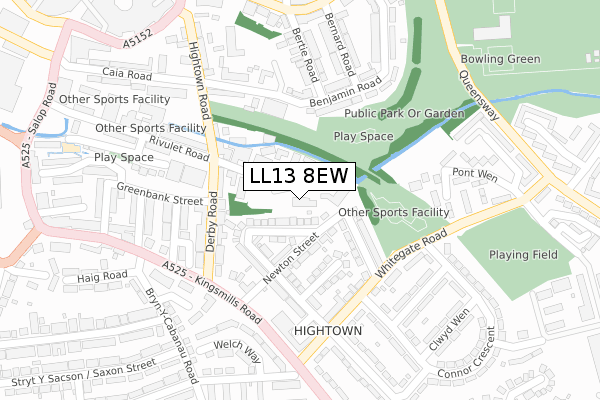
LL13 8EW is located in the Smithfield electoral ward, within the unitary authority of Wrexham and the Welsh Parliamentary constituency of Wrexham. The Local Health Board is Betsi Cadwaladr University and the police force is North Wales. This postcode has been in use since January 2019.


GetTheData
Source: OS Open Zoomstack (Ordnance Survey)
Licence: Open Government Licence (requires attribution)
Attribution: Contains OS data © Crown copyright and database right 2025
Source: Open Postcode Geo
Licence: Open Government Licence (requires attribution)
Attribution: Contains OS data © Crown copyright and database right 2025; Contains Royal Mail data © Royal Mail copyright and database right 2025; Source: Office for National Statistics licensed under the Open Government Licence v.3.0
| Easting | 334221 |
| Northing | 349815 |
| Latitude | 53.041558 |
| Longitude | -2.982538 |
GetTheData
Source: Open Postcode Geo
Licence: Open Government Licence
| Country | Wales |
| Postcode District | LL13 |
➜ See where LL13 is on a map ➜ Where is Wrexham? | |
GetTheData
Source: Land Registry Price Paid Data
Licence: Open Government Licence
| Ward | Smithfield |
| Constituency | Wrexham |
GetTheData
Source: ONS Postcode Database
Licence: Open Government Licence
| Warwick Avenue (Whitegate Road) | Hightown | 201m |
| Warwick Avenue (Whitegate Road) | Hightown | 203m |
| Bernard Road | The Dunks | 218m |
| Benjamin Road | Smithfield Road | 220m |
| Bernard Road | The Dunks | 223m |
| Wrexham Central Station | 1.2km |
| Wrexham General Station | 1.6km |
| Gwersyllt Station | 4.2km |
GetTheData
Source: NaPTAN
Licence: Open Government Licence
| Percentage of properties with Next Generation Access | 100.0% |
| Percentage of properties with Superfast Broadband | 100.0% |
| Percentage of properties with Ultrafast Broadband | 0.0% |
| Percentage of properties with Full Fibre Broadband | 0.0% |
Superfast Broadband is between 30Mbps and 300Mbps
Ultrafast Broadband is > 300Mbps
| Median download speed | 32.8Mbps |
| Average download speed | 25.6Mbps |
| Maximum download speed | 40.00Mbps |
| Median upload speed | 6.8Mbps |
| Average upload speed | 5.6Mbps |
| Maximum upload speed | 10.00Mbps |
| Percentage of properties unable to receive 2Mbps | 0.0% |
| Percentage of properties unable to receive 5Mbps | 0.0% |
| Percentage of properties unable to receive 10Mbps | 0.0% |
| Percentage of properties unable to receive 30Mbps | 0.0% |
GetTheData
Source: Ofcom
Licence: Ofcom Terms of Use (requires attribution)
GetTheData
Source: ONS Postcode Database
Licence: Open Government Licence


➜ Get more ratings from the Food Standards Agency
GetTheData
Source: Food Standards Agency
Licence: FSA terms & conditions
| Last Collection | |||
|---|---|---|---|
| Location | Mon-Fri | Sat | Distance |
| High Street | 18:30 | 12:30 | 764m |
| High Street | 18:30 | 768m | |
| Town Hill Post Office | 16:45 | 11:30 | 862m |
GetTheData
Source: Dracos
Licence: Creative Commons Attribution-ShareAlike
The below table lists the International Territorial Level (ITL) codes (formerly Nomenclature of Territorial Units for Statistics (NUTS) codes) and Local Administrative Units (LAU) codes for LL13 8EW:
| ITL 1 Code | Name |
|---|---|
| TLL | Wales |
| ITL 2 Code | Name |
| TLL2 | East Wales |
| ITL 3 Code | Name |
| TLL23 | Flintshire and Wrexham |
| LAU 1 Code | Name |
| W06000006 | Wrexham |
GetTheData
Source: ONS Postcode Directory
Licence: Open Government Licence
The below table lists the Census Output Area (OA), Lower Layer Super Output Area (LSOA), and Middle Layer Super Output Area (MSOA) for LL13 8EW:
| Code | Name | |
|---|---|---|
| OA | W00002258 | |
| LSOA | W01000424 | Wrexham 012E |
| MSOA | W02000089 | Wrexham 012 |
GetTheData
Source: ONS Postcode Directory
Licence: Open Government Licence
| LL13 8DQ | Bentley Place | 72m |
| LL13 8PL | Rutland Road | 92m |
| LL13 8PE | Newton Street | 109m |
| LL13 8PH | St Johns Road | 137m |
| LL13 8PF | Linden Avenue | 142m |
| LL13 8DU | Rivulet Road | 146m |
| LL13 8DY | Rivulet Road | 148m |
| LL13 8EJ | Caia Gardens | 152m |
| LL13 8RB | Whitegate Road | 175m |
| LL13 8PU | Connor Crescent | 180m |
GetTheData
Source: Open Postcode Geo; Land Registry Price Paid Data
Licence: Open Government Licence