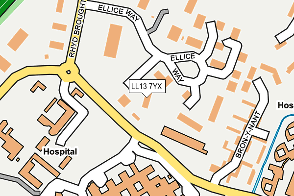
LL13 7YX is located in the Brynyffynnon electoral ward, within the unitary authority of Wrexham and the Welsh Parliamentary constituency of Wrexham. The Local Health Board is Betsi Cadwaladr University and the police force is North Wales. This postcode has been in use since December 1999.


GetTheData
Source: OS OpenMap – Local (Ordnance Survey)
Source: OS VectorMap District (Ordnance Survey)
Licence: Open Government Licence (requires attribution)
| Easting | 332329 |
| Northing | 350649 |
| Latitude | 53.048801 |
| Longitude | -3.010928 |
GetTheData
Source: Open Postcode Geo
Licence: Open Government Licence
| Country | Wales |
| Postcode District | LL13 |
➜ See where LL13 is on a map ➜ Where is Wrexham? | |
GetTheData
Source: Land Registry Price Paid Data
Licence: Open Government Licence
Elevation or altitude of LL13 7YX as distance above sea level:
| Metres | Feet | |
|---|---|---|
| Elevation | 90m | 295ft |
Elevation is measured from the approximate centre of the postcode, to the nearest point on an OS contour line from OS Terrain 50, which has contour spacing of ten vertical metres.
➜ How high above sea level am I? Find the elevation of your current position using your device's GPS.
GetTheData
Source: Open Postcode Elevation
Licence: Open Government Licence
| Ward | Brynyffynnon |
| Constituency | Wrexham |
GetTheData
Source: ONS Postcode Database
Licence: Open Government Licence
| Medical Institute (Croes Newydd Road) | Bryn Offa | 67m |
| Medical Institute (Croes Newydd Road) | Bryn Offa | 99m |
| Maelor Hospital Grounds (Grounds) | Bryn Offa | 120m |
| Bron-y-nant (Croes Newydd Road) | Bryn Offa | 188m |
| Tax Office (Rhyd Broughton Lane) | Wrexham | 250m |
| Wrexham General Station | 0.6km |
| Wrexham Central Station | 0.8km |
| Gwersyllt Station | 2.7km |
GetTheData
Source: NaPTAN
Licence: Open Government Licence
GetTheData
Source: ONS Postcode Database
Licence: Open Government Licence


➜ Get more ratings from the Food Standards Agency
GetTheData
Source: Food Standards Agency
Licence: FSA terms & conditions
| Last Collection | |||
|---|---|---|---|
| Location | Mon-Fri | Sat | Distance |
| Turf Hotel | 16:00 | 11:30 | 552m |
| Wrexham Sorting Office | 18:30 | 13:30 | 671m |
| Wrexham Delivery Office | 18:30 | 13:30 | 693m |
GetTheData
Source: Dracos
Licence: Creative Commons Attribution-ShareAlike
The below table lists the International Territorial Level (ITL) codes (formerly Nomenclature of Territorial Units for Statistics (NUTS) codes) and Local Administrative Units (LAU) codes for LL13 7YX:
| ITL 1 Code | Name |
|---|---|
| TLL | Wales |
| ITL 2 Code | Name |
| TLL2 | East Wales |
| ITL 3 Code | Name |
| TLL23 | Flintshire and Wrexham |
| LAU 1 Code | Name |
| W06000006 | Wrexham |
GetTheData
Source: ONS Postcode Directory
Licence: Open Government Licence
The below table lists the Census Output Area (OA), Lower Layer Super Output Area (LSOA), and Middle Layer Super Output Area (MSOA) for LL13 7YX:
| Code | Name | |
|---|---|---|
| OA | W00010041 | |
| LSOA | W01000350 | Wrexham 011B |
| MSOA | W02000088 | Wrexham 011 |
GetTheData
Source: ONS Postcode Directory
Licence: Open Government Licence
| LL13 7YT | Ellice Way | 80m |
| LL13 7YP | 214m | |
| LL11 2BG | Belvedere Drive | 322m |
| LL11 2AY | Plas Y Ffynnon | 353m |
| LL11 2AQ | Primrose Way | 374m |
| LL11 2AX | Yale Park | 384m |
| LL11 2BB | Lilac Way | 398m |
| LL11 2BD | Windsor Drive | 404m |
| LL11 2BE | Gloucester Drive | 434m |
| LL11 2BH | Berse Road | 446m |
GetTheData
Source: Open Postcode Geo; Land Registry Price Paid Data
Licence: Open Government Licence