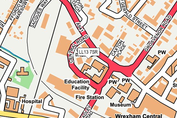
LL13 7SR is located in the Brynyffynnon electoral ward, within the unitary authority of Wrexham and the Welsh Parliamentary constituency of Wrexham. The Local Health Board is Betsi Cadwaladr University and the police force is North Wales. This postcode has been in use since June 2001.


GetTheData
Source: OS OpenMap – Local (Ordnance Survey)
Source: OS VectorMap District (Ordnance Survey)
Licence: Open Government Licence (requires attribution)
| Easting | 333028 |
| Northing | 350562 |
| Latitude | 53.048107 |
| Longitude | -3.000484 |
GetTheData
Source: Open Postcode Geo
Licence: Open Government Licence
| Country | Wales |
| Postcode District | LL13 |
➜ See where LL13 is on a map ➜ Where is Wrexham? | |
GetTheData
Source: Land Registry Price Paid Data
Licence: Open Government Licence
Elevation or altitude of LL13 7SR as distance above sea level:
| Metres | Feet | |
|---|---|---|
| Elevation | 90m | 295ft |
Elevation is measured from the approximate centre of the postcode, to the nearest point on an OS contour line from OS Terrain 50, which has contour spacing of ten vertical metres.
➜ How high above sea level am I? Find the elevation of your current position using your device's GPS.
GetTheData
Source: Open Postcode Elevation
Licence: Open Government Licence
| Ward | Brynyffynnon |
| Constituency | Wrexham |
GetTheData
Source: ONS Postcode Database
Licence: Open Government Licence
| School Of Art (Regent Street) | Wrexham | 45m |
| Fire Station (Bradley Road) | Wrecsam | 63m |
| Central Retail Park (Regent Street) | Wrecsam | 79m |
| Fire Station (Bradley Road) | Wrexham | 95m |
| Wrexham General Station (Station Approach) | Plas Coch | 207m |
| Wrexham Central Station | 0.2km |
| Wrexham General Station | 0.3km |
| Gwersyllt Station | 3km |
GetTheData
Source: NaPTAN
Licence: Open Government Licence
GetTheData
Source: ONS Postcode Database
Licence: Open Government Licence


➜ Get more ratings from the Food Standards Agency
GetTheData
Source: Food Standards Agency
Licence: FSA terms & conditions
| Last Collection | |||
|---|---|---|---|
| Location | Mon-Fri | Sat | Distance |
| Wrexham Sorting Office | 18:30 | 13:30 | 33m |
| Wrexham Delivery Office | 18:30 | 13:30 | 119m |
| Gerald Street Rhosddu | 17:00 | 11:30 | 215m |
GetTheData
Source: Dracos
Licence: Creative Commons Attribution-ShareAlike
The below table lists the International Territorial Level (ITL) codes (formerly Nomenclature of Territorial Units for Statistics (NUTS) codes) and Local Administrative Units (LAU) codes for LL13 7SR:
| ITL 1 Code | Name |
|---|---|
| TLL | Wales |
| ITL 2 Code | Name |
| TLL2 | East Wales |
| ITL 3 Code | Name |
| TLL23 | Flintshire and Wrexham |
| LAU 1 Code | Name |
| W06000006 | Wrexham |
GetTheData
Source: ONS Postcode Directory
Licence: Open Government Licence
The below table lists the Census Output Area (OA), Lower Layer Super Output Area (LSOA), and Middle Layer Super Output Area (MSOA) for LL13 7SR:
| Code | Name | |
|---|---|---|
| OA | W00001879 | |
| LSOA | W01000350 | Wrexham 011B |
| MSOA | W02000088 | Wrexham 011 |
GetTheData
Source: ONS Postcode Directory
Licence: Open Government Licence
| LL11 1PF | Regent Street | 35m |
| LL11 1PA | Caxton Place | 69m |
| LL11 1EH | Gerald Street | 185m |
| LL11 1RE | Regent Street | 192m |
| LL11 1EF | Grosvenor Gardens | 193m |
| LL11 1BS | Grosvenor Road | 206m |
| LL11 1BU | Grosvenor Road | 244m |
| LL13 7SY | Watery Road | 250m |
| LL13 7NP | Watery Road | 272m |
| LL11 1EL | Gerald Street | 277m |
GetTheData
Source: Open Postcode Geo; Land Registry Price Paid Data
Licence: Open Government Licence