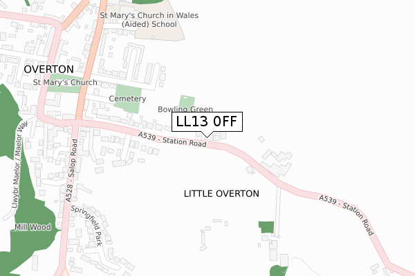
LL13 0FF is located in the Overton and Maelor South electoral ward, within the unitary authority of Wrexham and the Welsh Parliamentary constituency of Clwyd South. The Local Health Board is Betsi Cadwaladr University and the police force is North Wales. This postcode has been in use since November 2017.


GetTheData
Source: OS Open Zoomstack (Ordnance Survey)
Licence: Open Government Licence (requires attribution)
Attribution: Contains OS data © Crown copyright and database right 2025
Source: Open Postcode Geo
Licence: Open Government Licence (requires attribution)
Attribution: Contains OS data © Crown copyright and database right 2025; Contains Royal Mail data © Royal Mail copyright and database right 2025; Source: Office for National Statistics licensed under the Open Government Licence v.3.0
| Easting | 337680 |
| Northing | 341685 |
| Latitude | 52.968900 |
| Longitude | -2.929383 |
GetTheData
Source: Open Postcode Geo
Licence: Open Government Licence
| Country | Wales |
| Postcode District | LL13 |
➜ See where LL13 is on a map | |
GetTheData
Source: Land Registry Price Paid Data
Licence: Open Government Licence
| Ward | Overton And Maelor South |
| Constituency | Clwyd South |
GetTheData
Source: ONS Postcode Database
Licence: Open Government Licence
| Stableyard (Pen-y-llan Street) | Overton | 358m |
| Cocoa Rooms (Pen-y-llan Street) | Overton | 362m |
| White Horse Hotel (High Street) | Overton | 424m |
| Post Office (High Street) | Overton | 440m |
| Parkside (Turning Street) | Overton | 449m |
GetTheData
Source: NaPTAN
Licence: Open Government Licence
| Percentage of properties with Next Generation Access | 100.0% |
| Percentage of properties with Superfast Broadband | 100.0% |
| Percentage of properties with Ultrafast Broadband | 0.0% |
| Percentage of properties with Full Fibre Broadband | 0.0% |
Superfast Broadband is between 30Mbps and 300Mbps
Ultrafast Broadband is > 300Mbps
| Percentage of properties unable to receive 2Mbps | 0.0% |
| Percentage of properties unable to receive 5Mbps | 0.0% |
| Percentage of properties unable to receive 10Mbps | 0.0% |
| Percentage of properties unable to receive 30Mbps | 0.0% |
GetTheData
Source: Ofcom
Licence: Ofcom Terms of Use (requires attribution)
GetTheData
Source: ONS Postcode Database
Licence: Open Government Licence


➜ Get more ratings from the Food Standards Agency
GetTheData
Source: Food Standards Agency
Licence: FSA terms & conditions
| Last Collection | |||
|---|---|---|---|
| Location | Mon-Fri | Sat | Distance |
| Overton Post Office | 16:30 | 09:00 | 1,308m |
| Red Hall Lane | 16:30 | 08:15 | 2,213m |
| Penley Church | 17:00 | 08:15 | 3,906m |
GetTheData
Source: Dracos
Licence: Creative Commons Attribution-ShareAlike
The below table lists the International Territorial Level (ITL) codes (formerly Nomenclature of Territorial Units for Statistics (NUTS) codes) and Local Administrative Units (LAU) codes for LL13 0FF:
| ITL 1 Code | Name |
|---|---|
| TLL | Wales |
| ITL 2 Code | Name |
| TLL2 | East Wales |
| ITL 3 Code | Name |
| TLL23 | Flintshire and Wrexham |
| LAU 1 Code | Name |
| W06000006 | Wrexham |
GetTheData
Source: ONS Postcode Directory
Licence: Open Government Licence
The below table lists the Census Output Area (OA), Lower Layer Super Output Area (LSOA), and Middle Layer Super Output Area (MSOA) for LL13 0FF:
| Code | Name | |
|---|---|---|
| OA | W00002150 | |
| LSOA | W01000404 | Wrexham 018D |
| MSOA | W02000095 | Wrexham 018 |
GetTheData
Source: ONS Postcode Directory
Licence: Open Government Licence
| LL13 0EZ | Mill Court | 216m |
| LL13 0EF | Station Road | 230m |
| LL13 0LD | Hanmer Close | 247m |
| LL13 0ER | Plas Madoc | 247m |
| LL13 0LJ | Station Road | 279m |
| LL13 0EP | St Marys Avenue | 284m |
| LL13 0EN | Church Road | 304m |
| LL13 0EW | Poethlyn Terrace | 328m |
| LL13 0DX | Salop Mews | 331m |
| LL13 0DQ | Old School Mews | 335m |
GetTheData
Source: Open Postcode Geo; Land Registry Price Paid Data
Licence: Open Government Licence