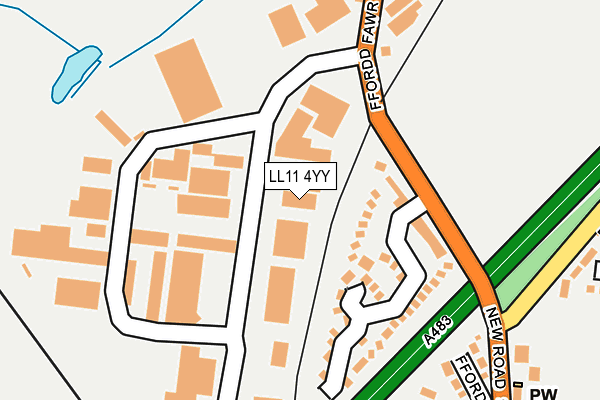
LL11 4YY is located in the Gwersyllt South electoral ward, within the unitary authority of Wrexham and the Welsh Parliamentary constituency of Wrexham. The Local Health Board is Betsi Cadwaladr University and the police force is North Wales. This postcode has been in use since April 2021.


GetTheData
Source: OS OpenMap – Local (Ordnance Survey)
Source: OS VectorMap District (Ordnance Survey)
Licence: Open Government Licence (requires attribution)
| Easting | 332796 |
| Northing | 352600 |
| Latitude | 53.066411 |
| Longitude | -3.004371 |
GetTheData
Source: Open Postcode Geo
Licence: Open Government Licence
| Country | Wales |
| Postcode District | LL11 |
➜ See where LL11 is on a map | |
GetTheData
Source: Land Registry Price Paid Data
Licence: Open Government Licence
Elevation or altitude of LL11 4YY as distance above sea level:
| Metres | Feet | |
|---|---|---|
| Elevation | 90m | 295ft |
Elevation is measured from the approximate centre of the postcode, to the nearest point on an OS contour line from OS Terrain 50, which has contour spacing of ten vertical metres.
➜ How high above sea level am I? Find the elevation of your current position using your device's GPS.
GetTheData
Source: Open Postcode Elevation
Licence: Open Government Licence
| Ward | Gwersyllt South |
| Constituency | Wrexham |
GetTheData
Source: ONS Postcode Database
Licence: Open Government Licence
| Dane Motors (Main Road) | Rhosrobin | 177m |
| Dane Motors (Main Road) | Rhosrobin | 184m |
| Olivet (Main Road) | Rhosrobin | 270m |
| Olivet (Main Road) | Rhosrobin | 275m |
| Post Office (Rhosrobin Road) | Rhosrobin | 306m |
| Gwersyllt Station | 1.1km |
| Wrexham General Station | 1.8km |
| Wrexham Central Station | 2.3km |
GetTheData
Source: NaPTAN
Licence: Open Government Licence
GetTheData
Source: ONS Postcode Database
Licence: Open Government Licence


➜ Get more ratings from the Food Standards Agency
GetTheData
Source: Food Standards Agency
Licence: FSA terms & conditions
| Last Collection | |||
|---|---|---|---|
| Location | Mon-Fri | Sat | Distance |
| Rhosrobin Post Office | 17:15 | 10:30 | 301m |
| Old Rhosrobin | 16:00 | 07:30 | 302m |
| Gwynfryn Bwlchgwyn | 11:00 | 10:15 | 819m |
GetTheData
Source: Dracos
Licence: Creative Commons Attribution-ShareAlike
The below table lists the International Territorial Level (ITL) codes (formerly Nomenclature of Territorial Units for Statistics (NUTS) codes) and Local Administrative Units (LAU) codes for LL11 4YY:
| ITL 1 Code | Name |
|---|---|
| TLL | Wales |
| ITL 2 Code | Name |
| TLL2 | East Wales |
| ITL 3 Code | Name |
| TLL23 | Flintshire and Wrexham |
| LAU 1 Code | Name |
| W06000006 | Wrexham |
GetTheData
Source: ONS Postcode Directory
Licence: Open Government Licence
The below table lists the Census Output Area (OA), Lower Layer Super Output Area (LSOA), and Middle Layer Super Output Area (MSOA) for LL11 4YY:
| Code | Name | |
|---|---|---|
| OA | W00002011 | |
| LSOA | W01000375 | Wrexham 003B |
| MSOA | W02000080 | Wrexham 003 |
GetTheData
Source: ONS Postcode Directory
Licence: Open Government Licence
| LL11 4RP | Sycamore Terrace | 189m |
| LL11 4RL | Main Road | 217m |
| LL11 4RW | Kendrick Terrace | 248m |
| LL11 4PX | Briarswood | 258m |
| LL11 4RN | Beirnes Terrace | 267m |
| LL11 2EZ | Top Farm Road | 270m |
| LL11 4RA | New Rhosrobin | 308m |
| LL11 4RJ | Olivet Gardens | 327m |
| LL11 4PJ | Maes Hyfryd | 328m |
| LL11 4PN | Rhosrobin Road | 345m |
GetTheData
Source: Open Postcode Geo; Land Registry Price Paid Data
Licence: Open Government Licence