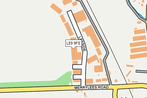
LE9 9FS lies on Merrylees Industrial Estate in Desford, Leicester. LE9 9FS is located in the Ratby, Bagworth and Thornton electoral ward, within the local authority district of Hinckley and Bosworth and the English Parliamentary constituency of Bosworth. The Sub Integrated Care Board (ICB) Location is NHS Leicester, Leicestershire and Rutland ICB - 04V and the police force is Leicestershire. This postcode has been in use since July 1986.


GetTheData
Source: OS OpenMap – Local (Ordnance Survey)
Source: OS VectorMap District (Ordnance Survey)
Licence: Open Government Licence (requires attribution)
| Easting | 446768 |
| Northing | 305950 |
| Latitude | 52.649293 |
| Longitude | -1.310148 |
GetTheData
Source: Open Postcode Geo
Licence: Open Government Licence
| Street | Merrylees Industrial Estate |
| Locality | Desford |
| Town/City | Leicester |
| Country | England |
| Postcode District | LE9 |
➜ See where LE9 is on a map ➜ Where is Merry Lees? | |
GetTheData
Source: Land Registry Price Paid Data
Licence: Open Government Licence
Elevation or altitude of LE9 9FS as distance above sea level:
| Metres | Feet | |
|---|---|---|
| Elevation | 110m | 361ft |
Elevation is measured from the approximate centre of the postcode, to the nearest point on an OS contour line from OS Terrain 50, which has contour spacing of ten vertical metres.
➜ How high above sea level am I? Find the elevation of your current position using your device's GPS.
GetTheData
Source: Open Postcode Elevation
Licence: Open Government Licence
| Ward | Ratby, Bagworth And Thornton |
| Constituency | Bosworth |
GetTheData
Source: ONS Postcode Database
Licence: Open Government Licence
| Botcheston Junction (Merrylees Road) | Merry Lees | 330m |
| Botcheston Junction (Merrylees Road) | Merry Lees | 345m |
| Garage (Merrylees Road) | Thornton | 1,425m |
| Garage (Merrylees Road) | Thornton | 1,440m |
| Greyhound (Main Street) | Botcheston | 1,544m |
GetTheData
Source: NaPTAN
Licence: Open Government Licence
| Median download speed | 30.4Mbps |
| Average download speed | 39.6Mbps |
| Maximum download speed | 80.00Mbps |
| Median upload speed | 5.6Mbps |
| Average upload speed | 9.7Mbps |
| Maximum upload speed | 20.00Mbps |
GetTheData
Source: Ofcom
Licence: Ofcom Terms of Use (requires attribution)
Estimated total energy consumption in LE9 9FS by fuel type, 2015.
| Consumption (kWh) | 260,676 |
|---|---|
| Meter count | 14 |
| Mean (kWh/meter) | 18,620 |
| Median (kWh/meter) | 10,022 |
GetTheData
Source: Postcode level gas estimates: 2015 (experimental)
Source: Postcode level electricity estimates: 2015 (experimental)
Licence: Open Government Licence
GetTheData
Source: ONS Postcode Database
Licence: Open Government Licence


➜ Get more ratings from the Food Standards Agency
GetTheData
Source: Food Standards Agency
Licence: FSA terms & conditions
| Last Collection | |||
|---|---|---|---|
| Location | Mon-Fri | Sat | Distance |
| Hunts Lane | 16:50 | 09:50 | 2,357m |
| Lindridge Lane | 16:50 | 10:00 | 2,490m |
| Station Road | 16:00 | 09:30 | 2,653m |
GetTheData
Source: Dracos
Licence: Creative Commons Attribution-ShareAlike
The below table lists the International Territorial Level (ITL) codes (formerly Nomenclature of Territorial Units for Statistics (NUTS) codes) and Local Administrative Units (LAU) codes for LE9 9FS:
| ITL 1 Code | Name |
|---|---|
| TLF | East Midlands (England) |
| ITL 2 Code | Name |
| TLF2 | Leicestershire, Rutland and Northamptonshire |
| ITL 3 Code | Name |
| TLF22 | Leicestershire CC and Rutland |
| LAU 1 Code | Name |
| E07000132 | Hinckley and Bosworth |
GetTheData
Source: ONS Postcode Directory
Licence: Open Government Licence
The below table lists the Census Output Area (OA), Lower Layer Super Output Area (LSOA), and Middle Layer Super Output Area (MSOA) for LE9 9FS:
| Code | Name | |
|---|---|---|
| OA | E00131314 | |
| LSOA | E01025878 | Hinckley and Bosworth 001E |
| MSOA | E02005377 | Hinckley and Bosworth 001 |
GetTheData
Source: ONS Postcode Directory
Licence: Open Government Licence
| LE9 9FE | Merrylees Road | 121m |
| LE67 1AP | Merrylees Road | 424m |
| LE9 9FD | Lindridge Lane | 903m |
| LE67 1AU | Oakwood Close | 1301m |
| LE67 1AN | Merrylees Road | 1327m |
| LE67 1AX | St Peters Drive | 1388m |
| LE67 1AE | Highfields | 1398m |
| LE67 1AD | Highfields | 1406m |
| LE67 1DG | Heath Road | 1432m |
| LE9 9QD | Hunts Close | 1433m |
GetTheData
Source: Open Postcode Geo; Land Registry Price Paid Data
Licence: Open Government Licence