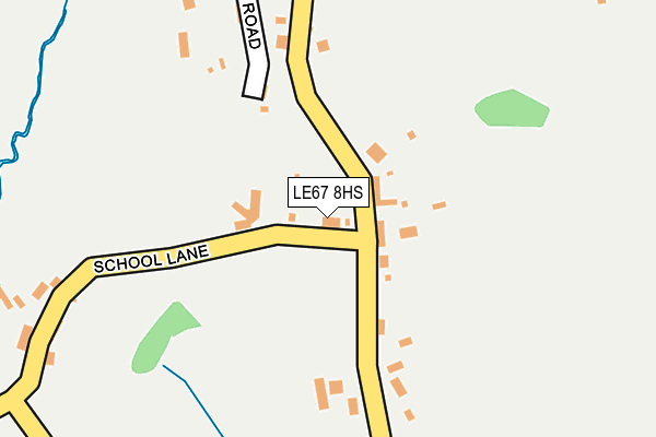
LE67 8HS lies on School Lane in Coleorton, Coalville. LE67 8HS is located in the Valley electoral ward, within the local authority district of North West Leicestershire and the English Parliamentary constituency of North West Leicestershire. The Sub Integrated Care Board (ICB) Location is NHS Leicester, Leicestershire and Rutland ICB - 04V and the police force is Leicestershire. This postcode has been in use since August 1992.


GetTheData
Source: OS OpenMap – Local (Ordnance Survey)
Source: OS VectorMap District (Ordnance Survey)
Licence: Open Government Licence (requires attribution)
| Easting | 441369 |
| Northing | 318188 |
| Latitude | 52.759721 |
| Longitude | -1.388420 |
GetTheData
Source: Open Postcode Geo
Licence: Open Government Licence
| Street | School Lane |
| Locality | Coleorton |
| Town/City | Coalville |
| Country | England |
| Postcode District | LE67 |
➜ See where LE67 is on a map ➜ Where is Coleorton? | |
GetTheData
Source: Land Registry Price Paid Data
Licence: Open Government Licence
Elevation or altitude of LE67 8HS as distance above sea level:
| Metres | Feet | |
|---|---|---|
| Elevation | 110m | 361ft |
Elevation is measured from the approximate centre of the postcode, to the nearest point on an OS contour line from OS Terrain 50, which has contour spacing of ten vertical metres.
➜ How high above sea level am I? Find the elevation of your current position using your device's GPS.
GetTheData
Source: Open Postcode Elevation
Licence: Open Government Licence
| Ward | Valley |
| Constituency | North West Leicestershire |
GetTheData
Source: ONS Postcode Database
Licence: Open Government Licence
HILLSIDE, SCHOOL LANE, COLEORTON, COALVILLE, LE67 8HS 1997 23 MAY £130,000 |
GetTheData
Source: HM Land Registry Price Paid Data
Licence: Contains HM Land Registry data © Crown copyright and database right 2025. This data is licensed under the Open Government Licence v3.0.
| The Tentas (Top Road) | Griffydam | 295m |
| The Tentas (Top Road) | Griffydam | 296m |
| Kellys Barn (Nottingham Road) | Peggs Green | 409m |
| Kellys Barn (Nottingham Rpad) | Peggs Green | 463m |
| Clay Lane (Zion Hill) | Peggs Green | 551m |
GetTheData
Source: NaPTAN
Licence: Open Government Licence
| Percentage of properties with Next Generation Access | 100.0% |
| Percentage of properties with Superfast Broadband | 100.0% |
| Percentage of properties with Ultrafast Broadband | 0.0% |
| Percentage of properties with Full Fibre Broadband | 0.0% |
Superfast Broadband is between 30Mbps and 300Mbps
Ultrafast Broadband is > 300Mbps
| Percentage of properties unable to receive 2Mbps | 0.0% |
| Percentage of properties unable to receive 5Mbps | 0.0% |
| Percentage of properties unable to receive 10Mbps | 0.0% |
| Percentage of properties unable to receive 30Mbps | 0.0% |
GetTheData
Source: Ofcom
Licence: Ofcom Terms of Use (requires attribution)
GetTheData
Source: ONS Postcode Database
Licence: Open Government Licence


➜ Get more ratings from the Food Standards Agency
GetTheData
Source: Food Standards Agency
Licence: FSA terms & conditions
| Last Collection | |||
|---|---|---|---|
| Location | Mon-Fri | Sat | Distance |
| Main Street | 16:00 | 11:45 | 2,320m |
| New Swannington | 16:45 | 11:30 | 2,601m |
| Lount Toll Gate | 16:00 | 08:15 | 2,929m |
GetTheData
Source: Dracos
Licence: Creative Commons Attribution-ShareAlike
The below table lists the International Territorial Level (ITL) codes (formerly Nomenclature of Territorial Units for Statistics (NUTS) codes) and Local Administrative Units (LAU) codes for LE67 8HS:
| ITL 1 Code | Name |
|---|---|
| TLF | East Midlands (England) |
| ITL 2 Code | Name |
| TLF2 | Leicestershire, Rutland and Northamptonshire |
| ITL 3 Code | Name |
| TLF22 | Leicestershire CC and Rutland |
| LAU 1 Code | Name |
| E07000134 | North West Leicestershire |
GetTheData
Source: ONS Postcode Directory
Licence: Open Government Licence
The below table lists the Census Output Area (OA), Lower Layer Super Output Area (LSOA), and Middle Layer Super Output Area (MSOA) for LE67 8HS:
| Code | Name | |
|---|---|---|
| OA | E00131751 | |
| LSOA | E01025964 | North West Leicestershire 005D |
| MSOA | E02005401 | North West Leicestershire 005 |
GetTheData
Source: ONS Postcode Directory
Licence: Open Government Licence
| LE67 8HN | Nottingham Road | 163m |
| LE67 8HB | Bottom Road | 236m |
| LE67 8HT | School Lane | 247m |
| LE67 8HW | The Tentas | 336m |
| LE67 8JE | Clay Lane | 367m |
| LE67 8JG | Nottingham Road | 373m |
| LE67 8HU | Top Road | 408m |
| LE67 8HA | Anchor Lane | 414m |
| LE67 8HD | Elder Lane | 492m |
| LE67 8JP | Zion Hill | 505m |
GetTheData
Source: Open Postcode Geo; Land Registry Price Paid Data
Licence: Open Government Licence