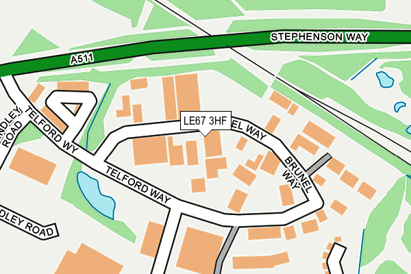
LE67 3HF lies on Brunel Way in Coalville. LE67 3HF is located in the Snibston North electoral ward, within the local authority district of North West Leicestershire and the English Parliamentary constituency of North West Leicestershire. The Sub Integrated Care Board (ICB) Location is NHS Leicester, Leicestershire and Rutland ICB - 04V and the police force is Leicestershire. This postcode has been in use since December 1998.


GetTheData
Source: OS OpenMap – Local (Ordnance Survey)
Source: OS VectorMap District (Ordnance Survey)
Licence: Open Government Licence (requires attribution)
| Easting | 441723 |
| Northing | 315031 |
| Latitude | 52.731334 |
| Longitude | -1.383566 |
GetTheData
Source: Open Postcode Geo
Licence: Open Government Licence
| Street | Brunel Way |
| Town/City | Coalville |
| Country | England |
| Postcode District | LE67 |
➜ See where LE67 is on a map ➜ Where is Coalville? | |
GetTheData
Source: Land Registry Price Paid Data
Licence: Open Government Licence
Elevation or altitude of LE67 3HF as distance above sea level:
| Metres | Feet | |
|---|---|---|
| Elevation | 150m | 492ft |
Elevation is measured from the approximate centre of the postcode, to the nearest point on an OS contour line from OS Terrain 50, which has contour spacing of ten vertical metres.
➜ How high above sea level am I? Find the elevation of your current position using your device's GPS.
GetTheData
Source: Open Postcode Elevation
Licence: Open Government Licence
| Ward | Snibston North |
| Constituency | North West Leicestershire |
GetTheData
Source: ONS Postcode Database
Licence: Open Government Licence
| Ravenstone Road (Ashby Road) | Coalville | 381m |
| Ravenstone Road (Ashby Road) | Coalville | 394m |
| Belmont Drive (Ashby Road) | Coalville | 460m |
| Belmont Drive (Ashby Road) | Coalville | 503m |
| Registery Office (Ravenstone Road) | Coalville | 513m |
GetTheData
Source: NaPTAN
Licence: Open Government Licence
| Median download speed | 31.6Mbps |
| Average download speed | 32.6Mbps |
| Maximum download speed | 40.00Mbps |
| Median upload speed | 6.3Mbps |
| Average upload speed | 5.9Mbps |
| Maximum upload speed | 9.70Mbps |
GetTheData
Source: Ofcom
Licence: Ofcom Terms of Use (requires attribution)
Estimated total energy consumption in LE67 3HF by fuel type, 2015.
| Consumption (kWh) | 218,403 |
|---|---|
| Meter count | 9 |
| Mean (kWh/meter) | 24,267 |
| Median (kWh/meter) | 25,396 |
GetTheData
Source: Postcode level gas estimates: 2015 (experimental)
Source: Postcode level electricity estimates: 2015 (experimental)
Licence: Open Government Licence
GetTheData
Source: ONS Postcode Database
Licence: Open Government Licence


➜ Get more ratings from the Food Standards Agency
GetTheData
Source: Food Standards Agency
Licence: FSA terms & conditions
| Last Collection | |||
|---|---|---|---|
| Location | Mon-Fri | Sat | Distance |
| Belvoir Road | 18:30 | 11:30 | 559m |
| Thornborough Road | 16:45 | 11:30 | 744m |
| Church Lane/Beadmans Close | 16:45 | 12:00 | 1,120m |
GetTheData
Source: Dracos
Licence: Creative Commons Attribution-ShareAlike
The below table lists the International Territorial Level (ITL) codes (formerly Nomenclature of Territorial Units for Statistics (NUTS) codes) and Local Administrative Units (LAU) codes for LE67 3HF:
| ITL 1 Code | Name |
|---|---|
| TLF | East Midlands (England) |
| ITL 2 Code | Name |
| TLF2 | Leicestershire, Rutland and Northamptonshire |
| ITL 3 Code | Name |
| TLF22 | Leicestershire CC and Rutland |
| LAU 1 Code | Name |
| E07000134 | North West Leicestershire |
GetTheData
Source: ONS Postcode Directory
Licence: Open Government Licence
The below table lists the Census Output Area (OA), Lower Layer Super Output Area (LSOA), and Middle Layer Super Output Area (MSOA) for LE67 3HF:
| Code | Name | |
|---|---|---|
| OA | E00131731 | |
| LSOA | E01025958 | North West Leicestershire 011C |
| MSOA | E02005407 | North West Leicestershire 011 |
GetTheData
Source: ONS Postcode Directory
Licence: Open Government Licence
| LE67 3HE | Telford Way | 173m |
| LE67 3AW | Discovery Close | 361m |
| LE67 3LD | Ashby Road | 378m |
| LE67 3ND | Bellway Close | 386m |
| LE67 3LL | All Saints Close | 406m |
| LE67 3LG | Ashby Road | 409m |
| LE67 3JZ | Ashby Road | 437m |
| LE67 3LH | Ashby Road | 448m |
| LE67 3LB | Ashby Road | 453m |
| LE67 3EJ | Ashby Road | 460m |
GetTheData
Source: Open Postcode Geo; Land Registry Price Paid Data
Licence: Open Government Licence