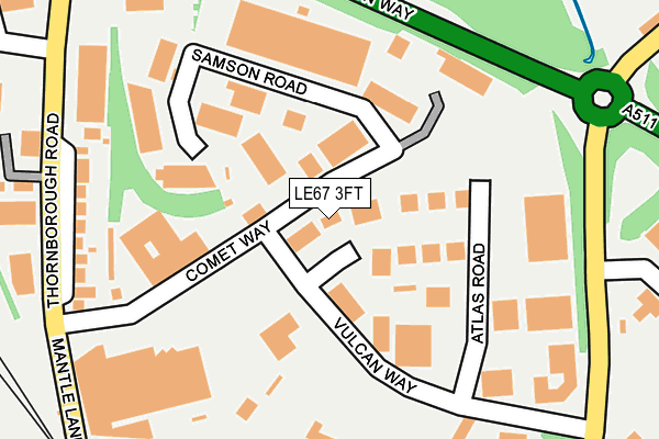
LE67 3FT is located in the Coalville West electoral ward, within the local authority district of North West Leicestershire and the English Parliamentary constituency of North West Leicestershire. The Sub Integrated Care Board (ICB) Location is NHS Leicester, Leicestershire and Rutland ICB - 04V and the police force is Leicestershire. This postcode has been in use since June 1997.


GetTheData
Source: OS OpenMap – Local (Ordnance Survey)
Source: OS VectorMap District (Ordnance Survey)
Licence: Open Government Licence (requires attribution)
| Easting | 442603 |
| Northing | 314892 |
| Latitude | 52.729998 |
| Longitude | -1.370562 |
GetTheData
Source: Open Postcode Geo
Licence: Open Government Licence
| Country | England |
| Postcode District | LE67 |
➜ See where LE67 is on a map ➜ Where is Coalville? | |
GetTheData
Source: Land Registry Price Paid Data
Licence: Open Government Licence
Elevation or altitude of LE67 3FT as distance above sea level:
| Metres | Feet | |
|---|---|---|
| Elevation | 150m | 492ft |
Elevation is measured from the approximate centre of the postcode, to the nearest point on an OS contour line from OS Terrain 50, which has contour spacing of ten vertical metres.
➜ How high above sea level am I? Find the elevation of your current position using your device's GPS.
GetTheData
Source: Open Postcode Elevation
Licence: Open Government Licence
| Ward | Coalville West |
| Constituency | North West Leicestershire |
GetTheData
Source: ONS Postcode Database
Licence: Open Government Licence
| Morrisons (Whitwick Road) | Coalville | 232m |
| Comet Way (Thornborough Road) | Coalville | 248m |
| Comet Way (Thornborough Road) | Coalville | 267m |
| Albert Road (Whitwick Road) | Coalville | 378m |
| Stephenson Way (Hermitage Road) | Whitwick | 403m |
GetTheData
Source: NaPTAN
Licence: Open Government Licence
GetTheData
Source: ONS Postcode Database
Licence: Open Government Licence


➜ Get more ratings from the Food Standards Agency
GetTheData
Source: Food Standards Agency
Licence: FSA terms & conditions
| Last Collection | |||
|---|---|---|---|
| Location | Mon-Fri | Sat | Distance |
| Thornborough Road | 16:45 | 11:30 | 525m |
| Belvoir Road | 18:30 | 11:30 | 806m |
| New Swannington | 16:45 | 11:30 | 1,040m |
GetTheData
Source: Dracos
Licence: Creative Commons Attribution-ShareAlike
The below table lists the International Territorial Level (ITL) codes (formerly Nomenclature of Territorial Units for Statistics (NUTS) codes) and Local Administrative Units (LAU) codes for LE67 3FT:
| ITL 1 Code | Name |
|---|---|
| TLF | East Midlands (England) |
| ITL 2 Code | Name |
| TLF2 | Leicestershire, Rutland and Northamptonshire |
| ITL 3 Code | Name |
| TLF22 | Leicestershire CC and Rutland |
| LAU 1 Code | Name |
| E07000134 | North West Leicestershire |
GetTheData
Source: ONS Postcode Directory
Licence: Open Government Licence
The below table lists the Census Output Area (OA), Lower Layer Super Output Area (LSOA), and Middle Layer Super Output Area (MSOA) for LE67 3FT:
| Code | Name | |
|---|---|---|
| OA | E00131588 | |
| LSOA | E01025930 | North West Leicestershire 010B |
| MSOA | E02005406 | North West Leicestershire 010 |
GetTheData
Source: ONS Postcode Directory
Licence: Open Government Licence
| LE67 3FS | Comet Way | 53m |
| LE67 3FP | Samson Road | 130m |
| LE67 3TH | Thornborough Road | 228m |
| LE67 3FA | Whitwick Road | 408m |
| LE67 5EH | Hermitage Road | 446m |
| LE67 5EQ | Bridge Mews | 461m |
| LE67 3FH | Old Station Close | 494m |
| LE67 3GB | Bridle Road | 499m |
| LE67 5EL | Hermitage Road | 557m |
| LE67 3ED | High Street | 566m |
GetTheData
Source: Open Postcode Geo; Land Registry Price Paid Data
Licence: Open Government Licence