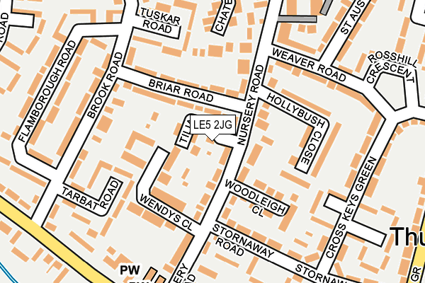
LE5 2JG is located in the Thurncourt electoral ward, within the unitary authority of Leicester and the English Parliamentary constituency of Leicester East. The Sub Integrated Care Board (ICB) Location is NHS Leicester, Leicestershire and Rutland ICB - 04C and the police force is Leicestershire. This postcode has been in use since April 2017.


GetTheData
Source: OS OpenMap – Local (Ordnance Survey)
Source: OS VectorMap District (Ordnance Survey)
Licence: Open Government Licence (requires attribution)
| Easting | 463841 |
| Northing | 305177 |
| Latitude | 52.640608 |
| Longitude | -1.057975 |
GetTheData
Source: Open Postcode Geo
Licence: Open Government Licence
| Country | England |
| Postcode District | LE5 |
➜ See where LE5 is on a map ➜ Where is Leicester? | |
GetTheData
Source: Land Registry Price Paid Data
Licence: Open Government Licence
| Ward | Thurncourt |
| Constituency | Leicester East |
GetTheData
Source: ONS Postcode Database
Licence: Open Government Licence
| Briar Road (Nursery Road) | Thurnby Lodge | 69m |
| Tuskar Road (Brook Road) | Thurnby Lodge | 163m |
| Tuskar Road (Brook Road) | Thurnby Lodge | 167m |
| Tarbat Road (Brook Road) | Thurnby Lodge | 184m |
| Chater Close (Nursery Road) | Thurnby Lodge | 191m |
| Leicester Station | 4.7km |
GetTheData
Source: NaPTAN
Licence: Open Government Licence
| Percentage of properties with Next Generation Access | 100.0% |
| Percentage of properties with Superfast Broadband | 100.0% |
| Percentage of properties with Ultrafast Broadband | 100.0% |
| Percentage of properties with Full Fibre Broadband | 0.0% |
Superfast Broadband is between 30Mbps and 300Mbps
Ultrafast Broadband is > 300Mbps
| Median download speed | 59.7Mbps |
| Average download speed | 65.0Mbps |
| Maximum download speed | 200.00Mbps |
| Median upload speed | 10.0Mbps |
| Average upload speed | 10.3Mbps |
| Maximum upload speed | 20.00Mbps |
| Percentage of properties unable to receive 2Mbps | 0.0% |
| Percentage of properties unable to receive 5Mbps | 0.0% |
| Percentage of properties unable to receive 10Mbps | 0.0% |
| Percentage of properties unable to receive 30Mbps | 0.0% |
GetTheData
Source: Ofcom
Licence: Ofcom Terms of Use (requires attribution)
GetTheData
Source: ONS Postcode Database
Licence: Open Government Licence


➜ Get more ratings from the Food Standards Agency
GetTheData
Source: Food Standards Agency
Licence: FSA terms & conditions
| Last Collection | |||
|---|---|---|---|
| Location | Mon-Fri | Sat | Distance |
| Grantham Road | 17:00 | 12:00 | 809m |
| Main Street | 16:45 | 09:30 | 977m |
| Spencefield Post Office | 17:00 | 12:00 | 1,311m |
GetTheData
Source: Dracos
Licence: Creative Commons Attribution-ShareAlike
The below table lists the International Territorial Level (ITL) codes (formerly Nomenclature of Territorial Units for Statistics (NUTS) codes) and Local Administrative Units (LAU) codes for LE5 2JG:
| ITL 1 Code | Name |
|---|---|
| TLF | East Midlands (England) |
| ITL 2 Code | Name |
| TLF2 | Leicestershire, Rutland and Northamptonshire |
| ITL 3 Code | Name |
| TLF21 | Leicester |
| LAU 1 Code | Name |
| E06000016 | Leicester |
GetTheData
Source: ONS Postcode Directory
Licence: Open Government Licence
The below table lists the Census Output Area (OA), Lower Layer Super Output Area (LSOA), and Middle Layer Super Output Area (MSOA) for LE5 2JG:
| Code | Name | |
|---|---|---|
| OA | E00069471 | |
| LSOA | E01013768 | Leicester 037D |
| MSOA | E02006815 | Leicester 037 |
GetTheData
Source: ONS Postcode Directory
Licence: Open Government Licence
| LE5 2HQ | Nursery Road | 54m |
| LE5 2HB | Briar Road | 55m |
| LE5 2HY | Wendys Close | 76m |
| LE5 2HA | Briar Road | 80m |
| LE5 2HW | Woodleigh Close | 154m |
| LE5 2HZ | Hollybush Close | 156m |
| LE5 2HE | Brook Road | 173m |
| LE5 2HX | Chater Close | 187m |
| LE5 2QP | Stornaway Road | 194m |
| LE5 2HL | Flamborough Road | 195m |
GetTheData
Source: Open Postcode Geo; Land Registry Price Paid Data
Licence: Open Government Licence