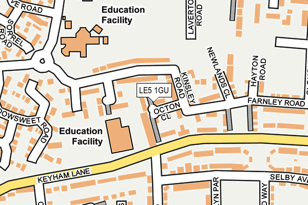
LE5 1GU is located in the Humberstone & Hamilton electoral ward, within the unitary authority of Leicester and the English Parliamentary constituency of Leicester East. The Sub Integrated Care Board (ICB) Location is NHS Leicester, Leicestershire and Rutland ICB - 04C and the police force is Leicestershire. This postcode has been in use since August 2018.


GetTheData
Source: OS OpenMap – Local (Ordnance Survey)
Source: OS VectorMap District (Ordnance Survey)
Licence: Open Government Licence (requires attribution)
| Easting | 463982 |
| Northing | 306557 |
| Latitude | 52.652996 |
| Longitude | -1.055625 |
GetTheData
Source: Open Postcode Geo
Licence: Open Government Licence
| Country | England |
| Postcode District | LE5 |
➜ See where LE5 is on a map ➜ Where is Leicester? | |
GetTheData
Source: Land Registry Price Paid Data
Licence: Open Government Licence
| Ward | Humberstone & Hamilton |
| Constituency | Leicester East |
GetTheData
Source: ONS Postcode Database
Licence: Open Government Licence
12, GATENBY CLOSE, HAMILTON, LEICESTER, LE5 1GU 2019 30 JAN £282,995 |
9, GATENBY CLOSE, HAMILTON, LEICESTER, LE5 1GU 2018 26 OCT £279,995 |
8, GATENBY CLOSE, HAMILTON, LEICESTER, LE5 1GU 2018 8 OCT £289,995 |
5, GATENBY CLOSE, HAMILTON, LEICESTER, LE5 1GU 2018 21 SEP £289,995 |
4, GATENBY CLOSE, HAMILTON, LEICESTER, LE5 1GU 2018 7 SEP £284,995 |
3, GATENBY CLOSE, HAMILTON, LEICESTER, LE5 1GU 2018 16 AUG £284,995 |
2, GATENBY CLOSE, HAMILTON, LEICESTER, LE5 1GU 2018 10 AUG £329,995 |
1, GATENBY CLOSE, HAMILTON, LEICESTER, LE5 1GU 2018 26 JUL £279,995 |
GetTheData
Source: HM Land Registry Price Paid Data
Licence: Contains HM Land Registry data © Crown copyright and database right 2025. This data is licensed under the Open Government Licence v3.0.
| Barry Road (Keyham Lane West) | Nether Hall | 167m |
| Selby Avenue (Ivychurch Crescent) | Nether Hall | 219m |
| Barry Road (Keyham Lane West) | Nether Hall | 251m |
| Netherhall Road (Ivychurch Crescent) | Nether Hall | 353m |
| Netherhall Road (Ivychurch Crescent) | Nether Hall | 390m |
| Syston Station | 4.9km |
| Leicester Station | 5.3km |
GetTheData
Source: NaPTAN
Licence: Open Government Licence
| Percentage of properties with Next Generation Access | 100.0% |
| Percentage of properties with Superfast Broadband | 100.0% |
| Percentage of properties with Ultrafast Broadband | 100.0% |
| Percentage of properties with Full Fibre Broadband | 0.0% |
Superfast Broadband is between 30Mbps and 300Mbps
Ultrafast Broadband is > 300Mbps
| Median download speed | 100.0Mbps |
| Average download speed | 88.2Mbps |
| Maximum download speed | 200.00Mbps |
| Median upload speed | 9.8Mbps |
| Average upload speed | 6.8Mbps |
| Maximum upload speed | 9.76Mbps |
| Percentage of properties unable to receive 2Mbps | 0.0% |
| Percentage of properties unable to receive 5Mbps | 0.0% |
| Percentage of properties unable to receive 10Mbps | 0.0% |
| Percentage of properties unable to receive 30Mbps | 0.0% |
GetTheData
Source: Ofcom
Licence: Ofcom Terms of Use (requires attribution)
GetTheData
Source: ONS Postcode Database
Licence: Open Government Licence


➜ Get more ratings from the Food Standards Agency
GetTheData
Source: Food Standards Agency
Licence: FSA terms & conditions
| Last Collection | |||
|---|---|---|---|
| Location | Mon-Fri | Sat | Distance |
| Grantham Road | 17:00 | 12:00 | 597m |
| Main Street | 16:45 | 09:30 | 1,006m |
| Maidenhead Avenue | 16:30 | 11:00 | 1,290m |
GetTheData
Source: Dracos
Licence: Creative Commons Attribution-ShareAlike
The below table lists the International Territorial Level (ITL) codes (formerly Nomenclature of Territorial Units for Statistics (NUTS) codes) and Local Administrative Units (LAU) codes for LE5 1GU:
| ITL 1 Code | Name |
|---|---|
| TLF | East Midlands (England) |
| ITL 2 Code | Name |
| TLF2 | Leicestershire, Rutland and Northamptonshire |
| ITL 3 Code | Name |
| TLF21 | Leicester |
| LAU 1 Code | Name |
| E06000016 | Leicester |
GetTheData
Source: ONS Postcode Directory
Licence: Open Government Licence
The below table lists the Census Output Area (OA), Lower Layer Super Output Area (LSOA), and Middle Layer Super Output Area (MSOA) for LE5 1GU:
| Code | Name | |
|---|---|---|
| OA | E00069139 | |
| LSOA | E01013695 | Leicester 037A |
| MSOA | E02006815 | Leicester 037 |
GetTheData
Source: ONS Postcode Directory
Licence: Open Government Licence
| LE5 1RS | Keyham Lane West | 168m |
| LE5 1ST | Selby Avenue | 175m |
| LE5 1GL | Kinsley Road | 224m |
| LE5 1RR | Ivychurch Crescent | 233m |
| LE5 1SS | Selby Avenue | 238m |
| LE5 1RJ | Crayford Way | 256m |
| LE5 1SR | Seaton Rise | 279m |
| LE5 1SA | Maplin Road | 282m |
| LE5 1WJ | Laverton Road | 285m |
| LE5 1SD | Newlyn Parade | 290m |
GetTheData
Source: Open Postcode Geo; Land Registry Price Paid Data
Licence: Open Government Licence