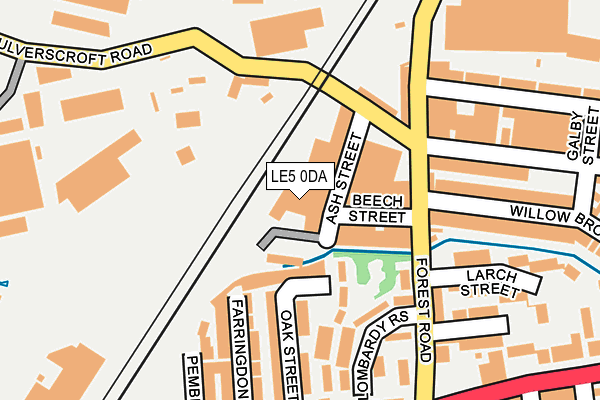
LE5 0DA is located in the North Evington electoral ward, within the unitary authority of Leicester and the English Parliamentary constituency of Leicester East. The Sub Integrated Care Board (ICB) Location is NHS Leicester, Leicestershire and Rutland ICB - 04C and the police force is Leicestershire. This postcode has been in use since January 1980.


GetTheData
Source: OS OpenMap – Local (Ordnance Survey)
Source: OS VectorMap District (Ordnance Survey)
Licence: Open Government Licence (requires attribution)
| Easting | 460321 |
| Northing | 305465 |
| Latitude | 52.643599 |
| Longitude | -1.109935 |
GetTheData
Source: Open Postcode Geo
Licence: Open Government Licence
| Country | England |
| Postcode District | LE5 |
➜ See where LE5 is on a map ➜ Where is Leicester? | |
GetTheData
Source: Land Registry Price Paid Data
Licence: Open Government Licence
Elevation or altitude of LE5 0DA as distance above sea level:
| Metres | Feet | |
|---|---|---|
| Elevation | 60m | 197ft |
Elevation is measured from the approximate centre of the postcode, to the nearest point on an OS contour line from OS Terrain 50, which has contour spacing of ten vertical metres.
➜ How high above sea level am I? Find the elevation of your current position using your device's GPS.
GetTheData
Source: Open Postcode Elevation
Licence: Open Government Licence
| Ward | North Evington |
| Constituency | Leicester East |
GetTheData
Source: ONS Postcode Database
Licence: Open Government Licence
| Lombardy Rise (Forest Road) | Spinney Hills | 148m |
| Lombardy Rise (Forest Road) | Spinney Hills | 156m |
| Prestwold Road (Forest Road) | Spinney Hills | 182m |
| Prestwold Road (Forest Road) | Spinney Hills | 198m |
| Spinney Hill Road (Humberstone Road) | Spinney Hills | 234m |
| Leicester Station | 1.7km |
GetTheData
Source: NaPTAN
Licence: Open Government Licence
GetTheData
Source: ONS Postcode Database
Licence: Open Government Licence


➜ Get more ratings from the Food Standards Agency
GetTheData
Source: Food Standards Agency
Licence: FSA terms & conditions
| Last Collection | |||
|---|---|---|---|
| Location | Mon-Fri | Sat | Distance |
| Willowbrook Road Post Office | 17:30 | 12:00 | 345m |
| Cobden Street | 479m | ||
| Melrose St Post Office | 17:00 | 12:00 | 656m |
GetTheData
Source: Dracos
Licence: Creative Commons Attribution-ShareAlike
| Risk of LE5 0DA flooding from rivers and sea | Medium |
| ➜ LE5 0DA flood map | |
GetTheData
Source: Open Flood Risk by Postcode
Licence: Open Government Licence
The below table lists the International Territorial Level (ITL) codes (formerly Nomenclature of Territorial Units for Statistics (NUTS) codes) and Local Administrative Units (LAU) codes for LE5 0DA:
| ITL 1 Code | Name |
|---|---|
| TLF | East Midlands (England) |
| ITL 2 Code | Name |
| TLF2 | Leicestershire, Rutland and Northamptonshire |
| ITL 3 Code | Name |
| TLF21 | Leicester |
| LAU 1 Code | Name |
| E06000016 | Leicester |
GetTheData
Source: ONS Postcode Directory
Licence: Open Government Licence
The below table lists the Census Output Area (OA), Lower Layer Super Output Area (LSOA), and Middle Layer Super Output Area (MSOA) for LE5 0DA:
| Code | Name | |
|---|---|---|
| OA | E00068936 | |
| LSOA | E01013654 | Leicester 017A |
| MSOA | E02002843 | Leicester 017 |
GetTheData
Source: ONS Postcode Directory
Licence: Open Government Licence
| LE5 0FN | Redwood Walk | 107m |
| LE5 0FP | Redwood Walk | 116m |
| LE5 0EN | Hammercliffe Road | 132m |
| LE5 0DW | Forest Road | 149m |
| LE5 0DT | Forest Road | 154m |
| LE5 0ET | Oak Street | 161m |
| LE5 0DU | Forest Road | 162m |
| LE5 0EB | Farringdon Street | 164m |
| LE5 0EU | Oak Street | 175m |
| LE5 0FE | Willow Brook Road | 187m |
GetTheData
Source: Open Postcode Geo; Land Registry Price Paid Data
Licence: Open Government Licence