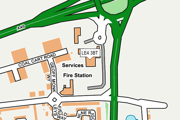
LE4 3BT is located in the Birstall West electoral ward, within the local authority district of Charnwood and the English Parliamentary constituency of Charnwood. The Sub Integrated Care Board (ICB) Location is NHS Leicester, Leicestershire and Rutland ICB - 04V and the police force is Leicestershire. This postcode has been in use since May 2009.


GetTheData
Source: OS OpenMap – Local (Ordnance Survey)
Source: OS VectorMap District (Ordnance Survey)
Licence: Open Government Licence (requires attribution)
| Easting | 459098 |
| Northing | 310679 |
| Latitude | 52.690601 |
| Longitude | -1.127076 |
GetTheData
Source: Open Postcode Geo
Licence: Open Government Licence
| Country | England |
| Postcode District | LE4 |
➜ See where LE4 is on a map ➜ Where is Birstall? | |
GetTheData
Source: Land Registry Price Paid Data
Licence: Open Government Licence
Elevation or altitude of LE4 3BT as distance above sea level:
| Metres | Feet | |
|---|---|---|
| Elevation | 80m | 262ft |
Elevation is measured from the approximate centre of the postcode, to the nearest point on an OS contour line from OS Terrain 50, which has contour spacing of ten vertical metres.
➜ How high above sea level am I? Find the elevation of your current position using your device's GPS.
GetTheData
Source: Open Postcode Elevation
Licence: Open Government Licence
| Ward | Birstall West |
| Constituency | Charnwood |
GetTheData
Source: ONS Postcode Database
Licence: Open Government Licence
| Birstall Meadow Road (Loughborough Road) | Birstall | 276m |
| Birstall Park And Ride (Loughborough Road) | Birstall | 288m |
| Birstall Meadow Road (Loughborough Road) | Birstall | 431m |
| Bentley Road (Loughborough Road) | Birstall | 668m |
| Sandgate Avenue (Harrowgate Drive) | Birstall | 725m |
| Syston Station | 3km |
| Sileby Station | 4.7km |
GetTheData
Source: NaPTAN
Licence: Open Government Licence
GetTheData
Source: ONS Postcode Database
Licence: Open Government Licence


➜ Get more ratings from the Food Standards Agency
GetTheData
Source: Food Standards Agency
Licence: FSA terms & conditions
| Last Collection | |||
|---|---|---|---|
| Location | Mon-Fri | Sat | Distance |
| Sycamore Road | 17:00 | 12:00 | 765m |
| Greengate Post Office | 17:00 | 12:00 | 1,007m |
| Poplar Avenue | 17:30 | 12:00 | 1,162m |
GetTheData
Source: Dracos
Licence: Creative Commons Attribution-ShareAlike
The below table lists the International Territorial Level (ITL) codes (formerly Nomenclature of Territorial Units for Statistics (NUTS) codes) and Local Administrative Units (LAU) codes for LE4 3BT:
| ITL 1 Code | Name |
|---|---|
| TLF | East Midlands (England) |
| ITL 2 Code | Name |
| TLF2 | Leicestershire, Rutland and Northamptonshire |
| ITL 3 Code | Name |
| TLF22 | Leicestershire CC and Rutland |
| LAU 1 Code | Name |
| E07000130 | Charnwood |
GetTheData
Source: ONS Postcode Directory
Licence: Open Government Licence
The below table lists the Census Output Area (OA), Lower Layer Super Output Area (LSOA), and Middle Layer Super Output Area (MSOA) for LE4 3BT:
| Code | Name | |
|---|---|---|
| OA | E00173331 | |
| LSOA | E01025679 | Charnwood 019A |
| MSOA | E02005363 | Charnwood 019 |
GetTheData
Source: ONS Postcode Directory
Licence: Open Government Licence
| LE4 3NL | Pen Lane Avenue | 220m |
| LE4 3NA | Birstall Meadow Road | 231m |
| LE4 3NJ | Nine Riggs Square | 235m |
| LE4 3EL | Field Leys Way | 243m |
| LE4 3NB | Barn Meadow Road | 273m |
| LE4 3NH | Long Roses Way | 283m |
| LE4 3EQ | Kevin Wood Close | 294m |
| LE4 3EP | Long Roses Way | 297m |
| LE4 3NE | Tithe Close | 335m |
| LE4 3LT | Little Pasture Road | 383m |
GetTheData
Source: Open Postcode Geo; Land Registry Price Paid Data
Licence: Open Government Licence