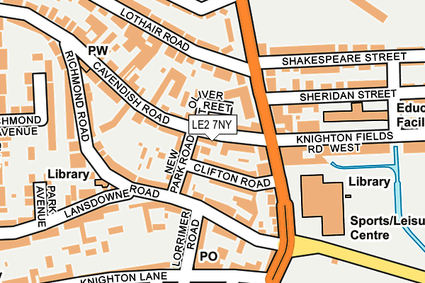
LE2 7NY is located in the Saffron electoral ward, within the unitary authority of Leicester and the English Parliamentary constituency of Leicester South. The Sub Integrated Care Board (ICB) Location is NHS Leicester, Leicestershire and Rutland ICB - 04C and the police force is Leicestershire. This postcode has been in use since May 2017.


GetTheData
Source: OS OpenMap – Local (Ordnance Survey)
Source: OS VectorMap District (Ordnance Survey)
Licence: Open Government Licence (requires attribution)
| Easting | 458481 |
| Northing | 301878 |
| Latitude | 52.611557 |
| Longitude | -1.137759 |
GetTheData
Source: Open Postcode Geo
Licence: Open Government Licence
| Country | England |
| Postcode District | LE2 |
➜ See where LE2 is on a map ➜ Where is Leicester? | |
GetTheData
Source: Land Registry Price Paid Data
Licence: Open Government Licence
| Ward | Saffron |
| Constituency | Leicester South |
GetTheData
Source: ONS Postcode Database
Licence: Open Government Licence
| Lothair Road (Saffron Lane) | Aylestone | 118m |
| Lansdowne Road (Saffron Lane) | Aylestone | 134m |
| Lothair Road (Saffron Lane) | Aylestone | 142m |
| Recreation Ground (Saffron Lane) | Aylestone | 264m |
| Aylestone Leisure Centre (Knighton Lane East) | Aylestone | 279m |
| Leicester Station | 2.4km |
| South Wigston Station | 3.3km |
| Narborough Station | 6.3km |
GetTheData
Source: NaPTAN
Licence: Open Government Licence
| Percentage of properties with Next Generation Access | 100.0% |
| Percentage of properties with Superfast Broadband | 100.0% |
| Percentage of properties with Ultrafast Broadband | 0.0% |
| Percentage of properties with Full Fibre Broadband | 0.0% |
Superfast Broadband is between 30Mbps and 300Mbps
Ultrafast Broadband is > 300Mbps
| Percentage of properties unable to receive 2Mbps | 0.0% |
| Percentage of properties unable to receive 5Mbps | 0.0% |
| Percentage of properties unable to receive 10Mbps | 0.0% |
| Percentage of properties unable to receive 30Mbps | 0.0% |
GetTheData
Source: Ofcom
Licence: Ofcom Terms of Use (requires attribution)
GetTheData
Source: ONS Postcode Database
Licence: Open Government Licence


➜ Get more ratings from the Food Standards Agency
GetTheData
Source: Food Standards Agency
Licence: FSA terms & conditions
| Last Collection | |||
|---|---|---|---|
| Location | Mon-Fri | Sat | Distance |
| Aylestone Park P.o. | 17:30 | 12:00 | 182m |
| Knighton Fields Road West | 17:30 | 12:00 | 244m |
| Middlesex Road | 17:00 | 12:00 | 279m |
GetTheData
Source: Dracos
Licence: Creative Commons Attribution-ShareAlike
| Risk of LE2 7NY flooding from rivers and sea | Medium |
| ➜ LE2 7NY flood map | |
GetTheData
Source: Open Flood Risk by Postcode
Licence: Open Government Licence
The below table lists the International Territorial Level (ITL) codes (formerly Nomenclature of Territorial Units for Statistics (NUTS) codes) and Local Administrative Units (LAU) codes for LE2 7NY:
| ITL 1 Code | Name |
|---|---|
| TLF | East Midlands (England) |
| ITL 2 Code | Name |
| TLF2 | Leicestershire, Rutland and Northamptonshire |
| ITL 3 Code | Name |
| TLF21 | Leicester |
| LAU 1 Code | Name |
| E06000016 | Leicester |
GetTheData
Source: ONS Postcode Directory
Licence: Open Government Licence
The below table lists the Census Output Area (OA), Lower Layer Super Output Area (LSOA), and Middle Layer Super Output Area (MSOA) for LE2 7NY:
| Code | Name | |
|---|---|---|
| OA | E00069119 | |
| LSOA | E01013688 | Leicester 031D |
| MSOA | E02002857 | Leicester 031 |
GetTheData
Source: ONS Postcode Directory
Licence: Open Government Licence
| LE2 7PJ | Cavendish Road | 38m |
| LE2 8AA | Clifton Road | 52m |
| LE2 8AW | New Park Road | 60m |
| LE2 7PD | Oliver Street | 73m |
| LE2 8AR | Lansdowne Road | 84m |
| LE2 7PL | Cavendish Road | 105m |
| LE2 7NE | Saffron Lane | 112m |
| LE2 8AT | Lansdowne Road | 113m |
| LE2 6UD | Saffron Lane | 117m |
| LE2 7NB | Saffron Lane | 131m |
GetTheData
Source: Open Postcode Geo; Land Registry Price Paid Data
Licence: Open Government Licence