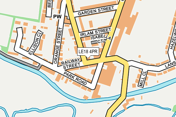
LE18 4PR is located in the South Wigston electoral ward, within the local authority district of Oadby and Wigston and the English Parliamentary constituency of Harborough. The Sub Integrated Care Board (ICB) Location is NHS Leicester, Leicestershire and Rutland ICB - 03W and the police force is Leicestershire. This postcode has been in use since August 1992.


GetTheData
Source: OS OpenMap – Local (Ordnance Survey)
Source: OS VectorMap District (Ordnance Survey)
Licence: Open Government Licence (requires attribution)
| Easting | 458788 |
| Northing | 297879 |
| Latitude | 52.575560 |
| Longitude | -1.133943 |
GetTheData
Source: Open Postcode Geo
Licence: Open Government Licence
| Country | England |
| Postcode District | LE18 |
➜ See where LE18 is on a map ➜ Where is Wigston? | |
GetTheData
Source: Land Registry Price Paid Data
Licence: Open Government Licence
Elevation or altitude of LE18 4PR as distance above sea level:
| Metres | Feet | |
|---|---|---|
| Elevation | 70m | 230ft |
Elevation is measured from the approximate centre of the postcode, to the nearest point on an OS contour line from OS Terrain 50, which has contour spacing of ten vertical metres.
➜ How high above sea level am I? Find the elevation of your current position using your device's GPS.
GetTheData
Source: Open Postcode Elevation
Licence: Open Government Licence
| Ward | South Wigston |
| Constituency | Harborough |
GetTheData
Source: ONS Postcode Database
Licence: Open Government Licence
| Park Road (Countesthorpe Road) | South Wigston | 23m |
| Park Road (Countesthorpe Road) | South Wigston | 32m |
| Irlam Street (Canal Street) | South Wigston | 96m |
| Timber Street (Countesthorpe Road) | South Wigston | 344m |
| Bassett Street (Canal Street) | South Wigston | 438m |
| South Wigston Station | 0.7km |
| Narborough Station | 4.7km |
GetTheData
Source: NaPTAN
Licence: Open Government Licence
GetTheData
Source: ONS Postcode Database
Licence: Open Government Licence


➜ Get more ratings from the Food Standards Agency
GetTheData
Source: Food Standards Agency
Licence: FSA terms & conditions
| Last Collection | |||
|---|---|---|---|
| Location | Mon-Fri | Sat | Distance |
| Park Road | 17:30 | 12:00 | 121m |
| Hazelwood Road | 17:30 | 12:30 | 293m |
| South Wigston Post Office | 17:30 | 12:45 | 482m |
GetTheData
Source: Dracos
Licence: Creative Commons Attribution-ShareAlike
The below table lists the International Territorial Level (ITL) codes (formerly Nomenclature of Territorial Units for Statistics (NUTS) codes) and Local Administrative Units (LAU) codes for LE18 4PR:
| ITL 1 Code | Name |
|---|---|
| TLF | East Midlands (England) |
| ITL 2 Code | Name |
| TLF2 | Leicestershire, Rutland and Northamptonshire |
| ITL 3 Code | Name |
| TLF22 | Leicestershire CC and Rutland |
| LAU 1 Code | Name |
| E07000135 | Oadby and Wigston |
GetTheData
Source: ONS Postcode Directory
Licence: Open Government Licence
The below table lists the Census Output Area (OA), Lower Layer Super Output Area (LSOA), and Middle Layer Super Output Area (MSOA) for LE18 4PR:
| Code | Name | |
|---|---|---|
| OA | E00131862 | |
| LSOA | E01025989 | Oadby and Wigston 006E |
| MSOA | E02005415 | Oadby and Wigston 006 |
GetTheData
Source: ONS Postcode Directory
Licence: Open Government Licence
| LE18 4QE | Railway Street | 54m |
| LE18 4PG | Countesthorpe Road | 57m |
| LE18 4QA | Irlam Street | 98m |
| LE18 4AD | Park Road | 109m |
| LE18 4PN | Canal Street | 110m |
| LE18 4QD | Park Road | 124m |
| LE18 4QB | Orange Street | 143m |
| LE18 4QH | Ellison Close | 171m |
| LE18 4PW | Garden Street | 180m |
| LE18 4NB | Mill Close | 183m |
GetTheData
Source: Open Postcode Geo; Land Registry Price Paid Data
Licence: Open Government Licence