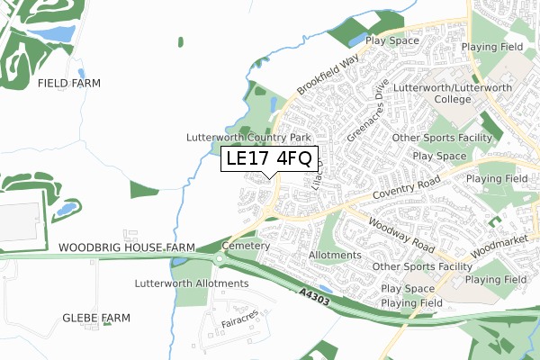
LE17 4FQ is located in the Lutterworth West electoral ward, within the local authority district of Harborough and the English Parliamentary constituency of South Leicestershire. The Sub Integrated Care Board (ICB) Location is NHS Leicester, Leicestershire and Rutland ICB - 03W and the police force is Leicestershire. This postcode has been in use since November 2019.


GetTheData
Source: OS Open Zoomstack (Ordnance Survey)
Licence: Open Government Licence (requires attribution)
Attribution: Contains OS data © Crown copyright and database right 2025
Source: Open Postcode Geo
Licence: Open Government Licence (requires attribution)
Attribution: Contains OS data © Crown copyright and database right 2025; Contains Royal Mail data © Royal Mail copyright and database right 2025; Source: Office for National Statistics licensed under the Open Government Licence v.3.0
| Easting | 453056 |
| Northing | 284537 |
| Latitude | 52.456234 |
| Longitude | -1.220629 |
GetTheData
Source: Open Postcode Geo
Licence: Open Government Licence
| Country | England |
| Postcode District | LE17 |
➜ See where LE17 is on a map ➜ Where is Lutterworth? | |
GetTheData
Source: Land Registry Price Paid Data
Licence: Open Government Licence
| Ward | Lutterworth West |
| Constituency | South Leicestershire |
GetTheData
Source: ONS Postcode Database
Licence: Open Government Licence
2021 15 OCT £392,000 |
3, VALLEY CLOSE, LUTTERWORTH, LE17 4FQ 2020 14 FEB £329,950 |
15, VALLEY CLOSE, LUTTERWORTH, LE17 4FQ 2020 17 JAN £369,950 |
11, VALLEY CLOSE, LUTTERWORTH, LE17 4FQ 2020 9 JAN £329,950 |
2019 17 DEC £369,950 |
1, VALLEY CLOSE, LUTTERWORTH, LE17 4FQ 2019 13 DEC £299,950 |
13, VALLEY CLOSE, LUTTERWORTH, LE17 4FQ 2019 29 NOV £329,950 |
GetTheData
Source: HM Land Registry Price Paid Data
Licence: Contains HM Land Registry data © Crown copyright and database right 2025. This data is licensed under the Open Government Licence v3.0.
| Woodway Road (Coventry Road) | Lutterworth | 323m |
| Woodway Road (Coventry Road) | Lutterworth | 337m |
| Chestnut Avenue (Greenacres Drive) | Lutterworth | 400m |
| Meriton Road (Woodway Road) | Lutterworth | 433m |
| Woodlea Avenue (Greenacres Drive) | Lutterworth | 628m |
GetTheData
Source: NaPTAN
Licence: Open Government Licence
GetTheData
Source: ONS Postcode Database
Licence: Open Government Licence


➜ Get more ratings from the Food Standards Agency
GetTheData
Source: Food Standards Agency
Licence: FSA terms & conditions
| Last Collection | |||
|---|---|---|---|
| Location | Mon-Fri | Sat | Distance |
| Macauley Road | 17:30 | 11:30 | 1,347m |
| Leicester Road | 17:30 | 11:30 | 1,710m |
| Ashby Parva | 17:00 | 10:30 | 3,839m |
GetTheData
Source: Dracos
Licence: Creative Commons Attribution-ShareAlike
The below table lists the International Territorial Level (ITL) codes (formerly Nomenclature of Territorial Units for Statistics (NUTS) codes) and Local Administrative Units (LAU) codes for LE17 4FQ:
| ITL 1 Code | Name |
|---|---|
| TLF | East Midlands (England) |
| ITL 2 Code | Name |
| TLF2 | Leicestershire, Rutland and Northamptonshire |
| ITL 3 Code | Name |
| TLF22 | Leicestershire CC and Rutland |
| LAU 1 Code | Name |
| E07000131 | Harborough |
GetTheData
Source: ONS Postcode Directory
Licence: Open Government Licence
The below table lists the Census Output Area (OA), Lower Layer Super Output Area (LSOA), and Middle Layer Super Output Area (MSOA) for LE17 4FQ:
| Code | Name | |
|---|---|---|
| OA | E00130848 | |
| LSOA | E01025790 | Harborough 010A |
| MSOA | E02005376 | Harborough 010 |
GetTheData
Source: ONS Postcode Directory
Licence: Open Government Licence
| LE17 4GP | Lavender Close | 179m |
| LE17 4FR | Azalea Close | 181m |
| LE17 4FD | Forsythia Close | 212m |
| LE17 4FP | Lilac Drive | 226m |
| LE17 4YX | Woodbrig Close | 228m |
| LE17 4YY | Palisade Close | 270m |
| LE17 4FH | Allfrey Close | 274m |
| LE17 4FS | Robinia Close | 292m |
| LE17 4FN | Honeysuckle Close | 324m |
| LE17 4GR | Jasmine Close | 342m |
GetTheData
Source: Open Postcode Geo; Land Registry Price Paid Data
Licence: Open Government Licence