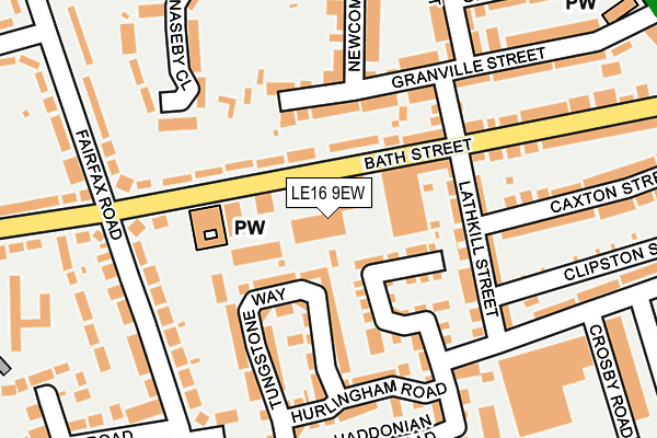
LE16 9EW is located in the Market Harborough-Welland electoral ward, within the local authority district of Harborough and the English Parliamentary constituency of Harborough. The Sub Integrated Care Board (ICB) Location is NHS Leicester, Leicestershire and Rutland ICB - 03W and the police force is Leicestershire. This postcode has been in use since February 1984.


GetTheData
Source: OS OpenMap – Local (Ordnance Survey)
Source: OS VectorMap District (Ordnance Survey)
Licence: Open Government Licence (requires attribution)
| Easting | 473412 |
| Northing | 286388 |
| Latitude | 52.470502 |
| Longitude | -0.920719 |
GetTheData
Source: Open Postcode Geo
Licence: Open Government Licence
| Country | England |
| Postcode District | LE16 |
➜ See where LE16 is on a map ➜ Where is Market Harborough? | |
GetTheData
Source: Land Registry Price Paid Data
Licence: Open Government Licence
Elevation or altitude of LE16 9EW as distance above sea level:
| Metres | Feet | |
|---|---|---|
| Elevation | 90m | 295ft |
Elevation is measured from the approximate centre of the postcode, to the nearest point on an OS contour line from OS Terrain 50, which has contour spacing of ten vertical metres.
➜ How high above sea level am I? Find the elevation of your current position using your device's GPS.
GetTheData
Source: Open Postcode Elevation
Licence: Open Government Licence
| Ward | Market Harborough-welland |
| Constituency | Harborough |
GetTheData
Source: ONS Postcode Database
Licence: Open Government Licence
| Courtyard Workshops (Bath Street) | Market Harborough | 37m |
| Courtyard Workshops (Bath Street) | Market Harborough | 48m |
| Caxton Street (Lathkill Street) | Market Harborough | 134m |
| Western Avenue (Fairfax Road) | Market Harborough | 196m |
| Crosby Road (Lathkill Street) | Market Harborough | 209m |
| Market Harborough Station | 1.3km |
GetTheData
Source: NaPTAN
Licence: Open Government Licence
Estimated total energy consumption in LE16 9EW by fuel type, 2015.
| Consumption (kWh) | 83,664 |
|---|---|
| Meter count | 8 |
| Mean (kWh/meter) | 10,458 |
| Median (kWh/meter) | 9,298 |
GetTheData
Source: Postcode level gas estimates: 2015 (experimental)
Source: Postcode level electricity estimates: 2015 (experimental)
Licence: Open Government Licence
GetTheData
Source: ONS Postcode Database
Licence: Open Government Licence


➜ Get more ratings from the Food Standards Agency
GetTheData
Source: Food Standards Agency
Licence: FSA terms & conditions
| Last Collection | |||
|---|---|---|---|
| Location | Mon-Fri | Sat | Distance |
| Northampton Road Post Office | 17:30 | 10:45 | 390m |
| Western Avenue | 17:30 | 10:45 | 426m |
| Little Bowden Crossing | 17:15 | 10:45 | 427m |
GetTheData
Source: Dracos
Licence: Creative Commons Attribution-ShareAlike
The below table lists the International Territorial Level (ITL) codes (formerly Nomenclature of Territorial Units for Statistics (NUTS) codes) and Local Administrative Units (LAU) codes for LE16 9EW:
| ITL 1 Code | Name |
|---|---|
| TLF | East Midlands (England) |
| ITL 2 Code | Name |
| TLF2 | Leicestershire, Rutland and Northamptonshire |
| ITL 3 Code | Name |
| TLF22 | Leicestershire CC and Rutland |
| LAU 1 Code | Name |
| E07000131 | Harborough |
GetTheData
Source: ONS Postcode Directory
Licence: Open Government Licence
The below table lists the Census Output Area (OA), Lower Layer Super Output Area (LSOA), and Middle Layer Super Output Area (MSOA) for LE16 9EW:
| Code | Name | |
|---|---|---|
| OA | E00130926 | |
| LSOA | E01025807 | Harborough 009E |
| MSOA | E02005375 | Harborough 009 |
GetTheData
Source: ONS Postcode Directory
Licence: Open Government Licence
| LE16 9JL | Bath Street | 79m |
| LE16 9EQ | Sutton Court | 86m |
| LE16 9FJ | Bradford Street | 91m |
| LE16 9EY | Lathkill Street | 122m |
| LE16 9GG | Tungstone Way | 158m |
| LE16 9GA | Tungstone Way | 159m |
| LE16 9GB | Hurlingham Road | 172m |
| LE16 9JU | Fairfax Road | 175m |
| LE16 9EU | Granville Street | 178m |
| LE16 9NX | Naseby Close | 185m |
GetTheData
Source: Open Postcode Geo; Land Registry Price Paid Data
Licence: Open Government Licence