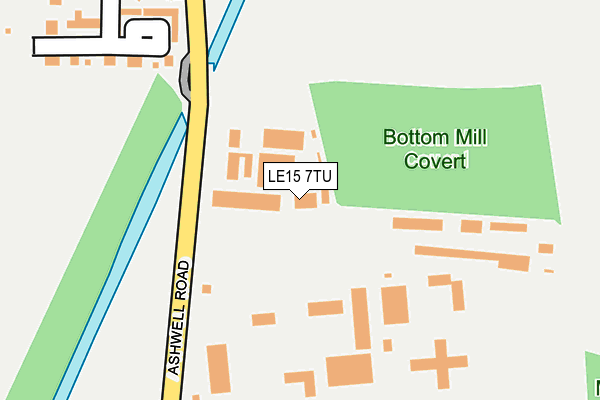
LE15 7TU is located in the Exton electoral ward, within the unitary authority of Rutland and the English Parliamentary constituency of Rutland and Melton. The Sub Integrated Care Board (ICB) Location is NHS Leicester, Leicestershire and Rutland ICB - 03W and the police force is Leicestershire. This postcode has been in use since October 2013.


GetTheData
Source: OS OpenMap – Local (Ordnance Survey)
Source: OS VectorMap District (Ordnance Survey)
Licence: Open Government Licence (requires attribution)
| Easting | 486769 |
| Northing | 311123 |
| Latitude | 52.690872 |
| Longitude | -0.717657 |
GetTheData
Source: Open Postcode Geo
Licence: Open Government Licence
| Country | England |
| Postcode District | LE15 |
➜ See where LE15 is on a map | |
GetTheData
Source: Land Registry Price Paid Data
Licence: Open Government Licence
Elevation or altitude of LE15 7TU as distance above sea level:
| Metres | Feet | |
|---|---|---|
| Elevation | 110m | 361ft |
Elevation is measured from the approximate centre of the postcode, to the nearest point on an OS contour line from OS Terrain 50, which has contour spacing of ten vertical metres.
➜ How high above sea level am I? Find the elevation of your current position using your device's GPS.
GetTheData
Source: Open Postcode Elevation
Licence: Open Government Licence
| Ward | Exton |
| Constituency | Rutland And Melton |
GetTheData
Source: ONS Postcode Database
Licence: Open Government Licence
| Oakham Enterprise Park (Oakham Road) | Ashwell | 113m |
| Oakham Enterprise Park (Oakham Road) | Ashwell | 161m |
| Co-op Superstore (Burley Road) | Burley | 1,270m |
| Withers Close (Schofield Road) | Oakham | 1,377m |
| Oakfield (Foxfield Way) | Oakham | 1,451m |
| Oakham Station | 2.4km |
GetTheData
Source: NaPTAN
Licence: Open Government Licence
| Median download speed | 9.1Mbps |
| Average download speed | 10.2Mbps |
| Maximum download speed | 18.96Mbps |
| Median upload speed | 0.8Mbps |
| Average upload speed | 0.8Mbps |
| Maximum upload speed | 1.27Mbps |
GetTheData
Source: Ofcom
Licence: Ofcom Terms of Use (requires attribution)
GetTheData
Source: ONS Postcode Database
Licence: Open Government Licence


➜ Get more ratings from the Food Standards Agency
GetTheData
Source: Food Standards Agency
Licence: FSA terms & conditions
| Last Collection | |||
|---|---|---|---|
| Location | Mon-Fri | Sat | Distance |
| Schofield Road | 17:30 | 11:00 | 1,412m |
| Springfield Way | 17:20 | 11:00 | 1,463m |
| Bullfinch Close | 17:20 | 11:00 | 1,576m |
GetTheData
Source: Dracos
Licence: Creative Commons Attribution-ShareAlike
The below table lists the International Territorial Level (ITL) codes (formerly Nomenclature of Territorial Units for Statistics (NUTS) codes) and Local Administrative Units (LAU) codes for LE15 7TU:
| ITL 1 Code | Name |
|---|---|
| TLF | East Midlands (England) |
| ITL 2 Code | Name |
| TLF2 | Leicestershire, Rutland and Northamptonshire |
| ITL 3 Code | Name |
| TLF22 | Leicestershire CC and Rutland |
| LAU 1 Code | Name |
| E06000017 | Rutland |
GetTheData
Source: ONS Postcode Directory
Licence: Open Government Licence
The below table lists the Census Output Area (OA), Lower Layer Super Output Area (LSOA), and Middle Layer Super Output Area (MSOA) for LE15 7TU:
| Code | Name | |
|---|---|---|
| OA | E00069561 | |
| LSOA | E01013789 | Rutland 001B |
| MSOA | E02002863 | Rutland 001 |
GetTheData
Source: ONS Postcode Directory
Licence: Open Government Licence
| LE15 7LG | Burley Crescent | 81m |
| LE15 7QP | Kimball Close | 435m |
| LE15 7QW | Kennel Cottages | 652m |
| LE15 7QN | Langham Place | 937m |
| LE15 7HZ | Burley Road | 1084m |
| LE15 6NE | Sunnyfield | 1293m |
| LE15 6ND | Limefield | 1328m |
| LE15 6GG | Withers Close | 1344m |
| LE15 6QB | Ashfield | 1349m |
| LE15 6PR | Foxfield Way | 1376m |
GetTheData
Source: Open Postcode Geo; Land Registry Price Paid Data
Licence: Open Government Licence