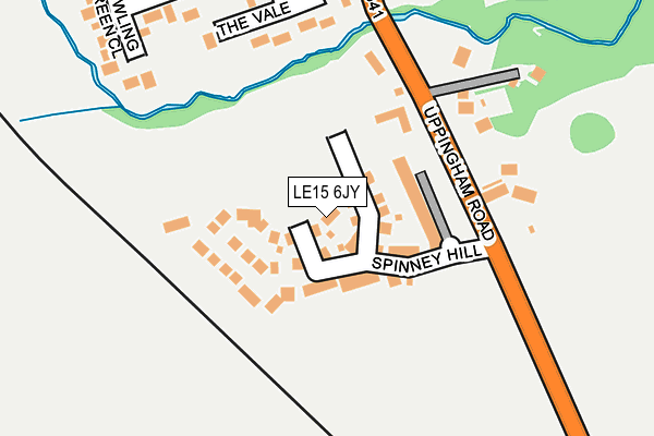
LE15 6JY is located in the Oakham South electoral ward, within the unitary authority of Rutland and the English Parliamentary constituency of Rutland and Melton. The Sub Integrated Care Board (ICB) Location is NHS Leicester, Leicestershire and Rutland ICB - 03W and the police force is Leicestershire. This postcode has been in use since July 2017.


GetTheData
Source: OS OpenMap – Local (Ordnance Survey)
Source: OS VectorMap District (Ordnance Survey)
Licence: Open Government Licence (requires attribution)
| Easting | 486267 |
| Northing | 308056 |
| Latitude | 52.663387 |
| Longitude | -0.725884 |
GetTheData
Source: Open Postcode Geo
Licence: Open Government Licence
| Country | England |
| Postcode District | LE15 |
➜ See where LE15 is on a map ➜ Where is Oakham? | |
GetTheData
Source: Land Registry Price Paid Data
Licence: Open Government Licence
| Ward | Oakham South |
| Constituency | Rutland And Melton |
GetTheData
Source: ONS Postcode Database
Licence: Open Government Licence
2, EGLETON PLACE, OAKHAM, LE15 6JY 2018 8 OCT £525,000 |
10, EGLETON PLACE, OAKHAM, LE15 6JY 2018 7 AUG £410,000 |
4, EGLETON PLACE, OAKHAM, LE15 6JY 2018 2 MAR £620,000 |
8, EGLETON PLACE, OAKHAM, LE15 6JY 2018 30 JAN £405,000 |
3, EGLETON PLACE, OAKHAM, LE15 6JY 2018 10 JAN £630,000 |
6, EGLETON PLACE, OAKHAM, LE15 6JY 2017 30 NOV £465,000 |
1, EGLETON PLACE, OAKHAM, LE15 6JY 2017 21 NOV £535,000 |
5, EGLETON PLACE, OAKHAM, LE15 6JY 2017 16 AUG £565,000 |
GetTheData
Source: HM Land Registry Price Paid Data
Licence: Contains HM Land Registry data © Crown copyright and database right 2025. This data is licensed under the Open Government Licence v3.0.
| Council Offices (Uppingham Road) | Oakham | 536m |
| Council Offices (Uppingham Road) | Oakham | 537m |
| Market Place (High Street) | Oakham | 693m |
| Market Place (High Street) | Oakham | 709m |
| Tesco (South Street) | Oakham | 721m |
| Oakham Station | 1.1km |
GetTheData
Source: NaPTAN
Licence: Open Government Licence
| Percentage of properties with Next Generation Access | 100.0% |
| Percentage of properties with Superfast Broadband | 100.0% |
| Percentage of properties with Ultrafast Broadband | 0.0% |
| Percentage of properties with Full Fibre Broadband | 0.0% |
Superfast Broadband is between 30Mbps and 300Mbps
Ultrafast Broadband is > 300Mbps
| Median download speed | 30.2Mbps |
| Average download speed | 28.7Mbps |
| Maximum download speed | 39.05Mbps |
| Median upload speed | 5.0Mbps |
| Average upload speed | 5.0Mbps |
| Maximum upload speed | 9.12Mbps |
| Percentage of properties unable to receive 2Mbps | 0.0% |
| Percentage of properties unable to receive 5Mbps | 0.0% |
| Percentage of properties unable to receive 10Mbps | 0.0% |
| Percentage of properties unable to receive 30Mbps | 0.0% |
GetTheData
Source: Ofcom
Licence: Ofcom Terms of Use (requires attribution)
GetTheData
Source: ONS Postcode Database
Licence: Open Government Licence


➜ Get more ratings from the Food Standards Agency
GetTheData
Source: Food Standards Agency
Licence: FSA terms & conditions
| Last Collection | |||
|---|---|---|---|
| Location | Mon-Fri | Sat | Distance |
| High Street | 16:45 | 07:00 | 782m |
| High Street | 17:30 | 11:00 | 845m |
| West End Post Office | 17:30 | 11:30 | 1,050m |
GetTheData
Source: Dracos
Licence: Creative Commons Attribution-ShareAlike
The below table lists the International Territorial Level (ITL) codes (formerly Nomenclature of Territorial Units for Statistics (NUTS) codes) and Local Administrative Units (LAU) codes for LE15 6JY:
| ITL 1 Code | Name |
|---|---|
| TLF | East Midlands (England) |
| ITL 2 Code | Name |
| TLF2 | Leicestershire, Rutland and Northamptonshire |
| ITL 3 Code | Name |
| TLF22 | Leicestershire CC and Rutland |
| LAU 1 Code | Name |
| E06000017 | Rutland |
GetTheData
Source: ONS Postcode Directory
Licence: Open Government Licence
The below table lists the Census Output Area (OA), Lower Layer Super Output Area (LSOA), and Middle Layer Super Output Area (MSOA) for LE15 6JY:
| Code | Name | |
|---|---|---|
| OA | E00069625 | |
| LSOA | E01013802 | Rutland 003C |
| MSOA | E02002865 | Rutland 003 |
GetTheData
Source: ONS Postcode Directory
Licence: Open Government Licence
| LE15 6JB | Uppingham Road | 176m |
| LE15 6JQ | The Vale | 193m |
| LE15 6HU | Uppingham Road | 200m |
| LE15 6HL | Bowling Green Close | 228m |
| LE15 6JD | Uppingham Road | 310m |
| LE15 6HT | Cricket Lawns | 316m |
| LE15 6JG | The Dell | 323m |
| LE15 6HJ | Brooke Road | 400m |
| LE15 6HY | South Street | 449m |
| LE15 6HG | Brooke Road | 467m |
GetTheData
Source: Open Postcode Geo; Land Registry Price Paid Data
Licence: Open Government Licence