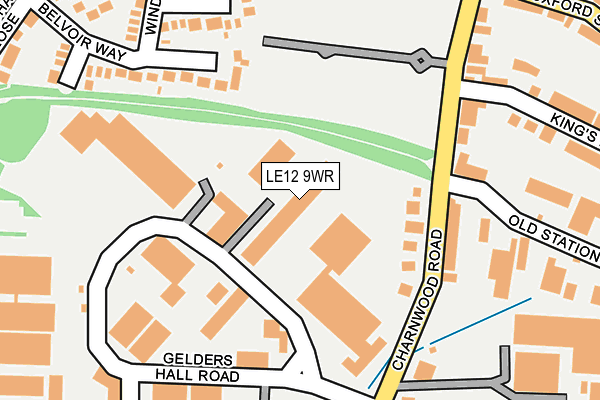
LE12 9WR is located in the Shepshed West electoral ward, within the local authority district of Charnwood and the English Parliamentary constituency of Loughborough. The Sub Integrated Care Board (ICB) Location is NHS Leicester, Leicestershire and Rutland ICB - 04V and the police force is Leicestershire. This postcode has been in use since February 2023.


GetTheData
Source: OS OpenMap – Local (Ordnance Survey)
Source: OS VectorMap District (Ordnance Survey)
Licence: Open Government Licence (requires attribution)
| Easting | 446472 |
| Northing | 318883 |
| Latitude | 52.765573 |
| Longitude | -1.312701 |
GetTheData
Source: Open Postcode Geo
Licence: Open Government Licence
| Country | England |
| Postcode District | LE12 |
➜ See where LE12 is on a map ➜ Where is Shepshed? | |
GetTheData
Source: Land Registry Price Paid Data
Licence: Open Government Licence
Elevation or altitude of LE12 9WR as distance above sea level:
| Metres | Feet | |
|---|---|---|
| Elevation | 90m | 295ft |
Elevation is measured from the approximate centre of the postcode, to the nearest point on an OS contour line from OS Terrain 50, which has contour spacing of ten vertical metres.
➜ How high above sea level am I? Find the elevation of your current position using your device's GPS.
GetTheData
Source: Open Postcode Elevation
Licence: Open Government Licence
| Ward | Shepshed West |
| Constituency | Loughborough |
GetTheData
Source: ONS Postcode Database
Licence: Open Government Licence
14, CHAMOMILE ROAD, SHEPSHED, LOUGHBOROUGH, LE12 9WR 2024 26 APR £410,000 |
20, CHAMOMILE ROAD, SHEPSHED, LOUGHBOROUGH, LE12 9WR 2024 8 APR £345,000 |
28, CHAMOMILE ROAD, SHEPSHED, LOUGHBOROUGH, LE12 9WR 2024 29 JAN £379,000 |
26, CHAMOMILE ROAD, SHEPSHED, LOUGHBOROUGH, LE12 9WR 2023 15 DEC £419,000 |
29, CHAMOMILE ROAD, SHEPSHED, LOUGHBOROUGH, LE12 9WR 2023 24 NOV £410,000 |
9, CHAMOMILE ROAD, SHEPSHED, LOUGHBOROUGH, LE12 9WR 2023 29 AUG £295,000 |
6, CHAMOMILE ROAD, SHEPSHED, LOUGHBOROUGH, LE12 9WR 2023 26 MAY £330,000 |
3, CHAMOMILE ROAD, SHEPSHED, LOUGHBOROUGH, LE12 9WR 2023 19 APR £384,000 |
2, CHAMOMILE ROAD, SHEPSHED, LOUGHBOROUGH, LE12 9WR 2023 2 MAR £360,000 |
4, CHAMOMILE ROAD, SHEPSHED, LOUGHBOROUGH, LE12 9WR 2023 1 MAR £345,000 |
GetTheData
Source: HM Land Registry Price Paid Data
Licence: Contains HM Land Registry data © Crown copyright and database right 2025. This data is licensed under the Open Government Licence v3.0.
| Charley Road (Ashby Road West) | Shepshed | 605m |
| Charley Road (Ashby Road West) | Shepshed | 634m |
| Griffin Close (Anson Road) | Shepshed | 679m |
| Chatsworth Close (Anson Road) | Shepshed | 682m |
| Chatsworth Close (Anson Road) | Shepshed | 688m |
GetTheData
Source: NaPTAN
Licence: Open Government Licence
GetTheData
Source: ONS Postcode Database
Licence: Open Government Licence


➜ Get more ratings from the Food Standards Agency
GetTheData
Source: Food Standards Agency
Licence: FSA terms & conditions
| Last Collection | |||
|---|---|---|---|
| Location | Mon-Fri | Sat | Distance |
| Hathern Road | 17:00 | 08:30 | 675m |
| Blackbrook A512 | 16:30 | 09:30 | 678m |
| Glenfield | 16:45 | 09:15 | 1,208m |
GetTheData
Source: Dracos
Licence: Creative Commons Attribution-ShareAlike
The below table lists the International Territorial Level (ITL) codes (formerly Nomenclature of Territorial Units for Statistics (NUTS) codes) and Local Administrative Units (LAU) codes for LE12 9WR:
| ITL 1 Code | Name |
|---|---|
| TLF | East Midlands (England) |
| ITL 2 Code | Name |
| TLF2 | Leicestershire, Rutland and Northamptonshire |
| ITL 3 Code | Name |
| TLF22 | Leicestershire CC and Rutland |
| LAU 1 Code | Name |
| E07000130 | Charnwood |
GetTheData
Source: ONS Postcode Directory
Licence: Open Government Licence
The below table lists the Census Output Area (OA), Lower Layer Super Output Area (LSOA), and Middle Layer Super Output Area (MSOA) for LE12 9WR:
| Code | Name | |
|---|---|---|
| OA | E00130623 | |
| LSOA | E01025746 | Charnwood 005C |
| MSOA | E02005349 | Charnwood 005 |
GetTheData
Source: ONS Postcode Directory
Licence: Open Government Licence
| LE12 9NE | Tamworth Close | 382m |
| LE12 9PN | Conway Drive | 420m |
| LE12 9NB | Penrith Avenue | 426m |
| LE12 9NF | Tetbury Drive | 445m |
| LE12 9QA | Buttercup Lane | 468m |
| LE12 9ND | Sandringham Rise | 495m |
| LE12 9PP | Conway Drive | 503m |
| LE12 9PL | Banbury Drive | 531m |
| LE12 9LZ | Norwich Close | 540m |
| LE12 9UU | Primrose Close | 541m |
GetTheData
Source: Open Postcode Geo; Land Registry Price Paid Data
Licence: Open Government Licence