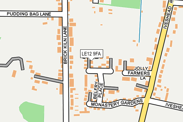
LE12 9FA is located in the Shepshed East electoral ward, within the local authority district of Charnwood and the English Parliamentary constituency of Loughborough. The Sub Integrated Care Board (ICB) Location is NHS Leicester, Leicestershire and Rutland ICB - 04V and the police force is Leicestershire. This postcode has been in use since April 2017.


GetTheData
Source: OS OpenMap – Local (Ordnance Survey)
Source: OS VectorMap District (Ordnance Survey)
Licence: Open Government Licence (requires attribution)
| Easting | 447161 |
| Northing | 317831 |
| Latitude | 52.756058 |
| Longitude | -1.302642 |
GetTheData
Source: Open Postcode Geo
Licence: Open Government Licence
| Country | England |
| Postcode District | LE12 |
➜ See where LE12 is on a map ➜ Where is Shepshed? | |
GetTheData
Source: Land Registry Price Paid Data
Licence: Open Government Licence
| Ward | Shepshed East |
| Constituency | Loughborough |
GetTheData
Source: ONS Postcode Database
Licence: Open Government Licence
2, FRIAR CLOSE, SHEPSHED, LOUGHBOROUGH, LE12 9FA 2017 31 MAY £294,950 |
8, FRIAR CLOSE, SHEPSHED, LOUGHBOROUGH, LE12 9FA 2017 26 MAY £326,950 |
4, FRIAR CLOSE, SHEPSHED, LOUGHBOROUGH, LE12 9FA 2017 26 MAY £275,950 |
6, FRIAR CLOSE, SHEPSHED, LOUGHBOROUGH, LE12 9FA 2017 26 MAY £275,950 |
5, FRIAR CLOSE, SHEPSHED, LOUGHBOROUGH, LE12 9FA 2017 28 APR £205,500 |
9, FRIAR CLOSE, SHEPSHED, LOUGHBOROUGH, LE12 9FA 2017 28 APR £295,950 |
11, FRIAR CLOSE, SHEPSHED, LOUGHBOROUGH, LE12 9FA 2017 26 APR £289,950 |
GetTheData
Source: HM Land Registry Price Paid Data
Licence: Contains HM Land Registry data © Crown copyright and database right 2025. This data is licensed under the Open Government Licence v3.0.
| Brick Kiln Lane (Ashby Road West) | Shepshed | 462m |
| Brick Kiln Lane (Ashby Road West) | Shepshed | 464m |
| Iveshead Road (Ashby Road West) | Shepshed | 474m |
| Iveshead Road (Charnwood Road) | Shepshed | 593m |
| Old Station Close (Charnwood Road) | Shepshed | 823m |
GetTheData
Source: NaPTAN
Licence: Open Government Licence
| Percentage of properties with Next Generation Access | 100.0% |
| Percentage of properties with Superfast Broadband | 100.0% |
| Percentage of properties with Ultrafast Broadband | 100.0% |
| Percentage of properties with Full Fibre Broadband | 0.0% |
Superfast Broadband is between 30Mbps and 300Mbps
Ultrafast Broadband is > 300Mbps
| Median download speed | 100.0Mbps |
| Average download speed | 156.9Mbps |
| Maximum download speed | 350.00Mbps |
| Median upload speed | 8.6Mbps |
| Average upload speed | 8.6Mbps |
| Maximum upload speed | 9.52Mbps |
| Percentage of properties unable to receive 2Mbps | 0.0% |
| Percentage of properties unable to receive 5Mbps | 0.0% |
| Percentage of properties unable to receive 10Mbps | 0.0% |
| Percentage of properties unable to receive 30Mbps | 0.0% |
GetTheData
Source: Ofcom
Licence: Ofcom Terms of Use (requires attribution)
GetTheData
Source: ONS Postcode Database
Licence: Open Government Licence


➜ Get more ratings from the Food Standards Agency
GetTheData
Source: Food Standards Agency
Licence: FSA terms & conditions
| Last Collection | |||
|---|---|---|---|
| Location | Mon-Fri | Sat | Distance |
| Hathern Road | 17:00 | 08:30 | 1,195m |
| Blackbrook A512 | 16:30 | 09:30 | 1,248m |
| Leicester Road | 17:30 | 09:30 | 1,308m |
GetTheData
Source: Dracos
Licence: Creative Commons Attribution-ShareAlike
The below table lists the International Territorial Level (ITL) codes (formerly Nomenclature of Territorial Units for Statistics (NUTS) codes) and Local Administrative Units (LAU) codes for LE12 9FA:
| ITL 1 Code | Name |
|---|---|
| TLF | East Midlands (England) |
| ITL 2 Code | Name |
| TLF2 | Leicestershire, Rutland and Northamptonshire |
| ITL 3 Code | Name |
| TLF22 | Leicestershire CC and Rutland |
| LAU 1 Code | Name |
| E07000130 | Charnwood |
GetTheData
Source: ONS Postcode Directory
Licence: Open Government Licence
The below table lists the Census Output Area (OA), Lower Layer Super Output Area (LSOA), and Middle Layer Super Output Area (MSOA) for LE12 9FA:
| Code | Name | |
|---|---|---|
| OA | E00173316 | |
| LSOA | E01025744 | Charnwood 005A |
| MSOA | E02005349 | Charnwood 005 |
GetTheData
Source: ONS Postcode Directory
Licence: Open Government Licence
| LE12 9FP | Belfry Place | 59m |
| LE12 9EJ | Brick Kiln Lane | 130m |
| LE12 9ET | Jolly Farmers Lane | 131m |
| LE12 9EL | Brick Kiln Lane | 150m |
| LE12 9GD | Pudding Bag Lane | 193m |
| LE12 9FG | The Pastures | 267m |
| LE12 9EP | Iveshead Road | 276m |
| LE12 9ER | Iveshead Road | 306m |
| LE12 9EX | Moscow Lane | 309m |
| LE12 9EH | Abbey Close | 351m |
GetTheData
Source: Open Postcode Geo; Land Registry Price Paid Data
Licence: Open Government Licence