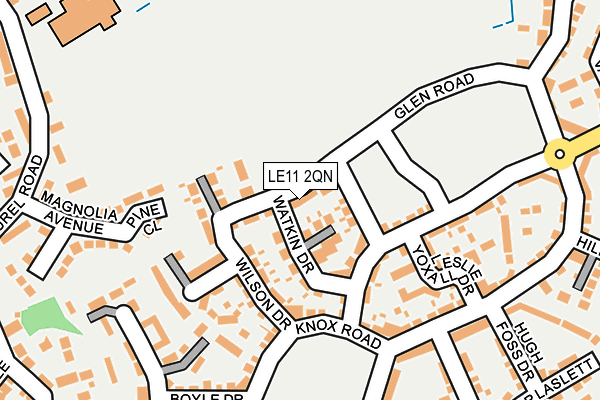
LE11 2QN is located in the Loughborough Woodthorpe electoral ward, within the local authority district of Charnwood and the English Parliamentary constituency of Loughborough. The Sub Integrated Care Board (ICB) Location is NHS Leicester, Leicestershire and Rutland ICB - 04V and the police force is Leicestershire. This postcode has been in use since May 2017.


GetTheData
Source: OS OpenMap – Local (Ordnance Survey)
Source: OS VectorMap District (Ordnance Survey)
Licence: Open Government Licence (requires attribution)
| Easting | 453698 |
| Northing | 317099 |
| Latitude | 52.748870 |
| Longitude | -1.205913 |
GetTheData
Source: Open Postcode Geo
Licence: Open Government Licence
| Country | England |
| Postcode District | LE11 |
➜ See where LE11 is on a map ➜ Where is Loughborough? | |
GetTheData
Source: Land Registry Price Paid Data
Licence: Open Government Licence
| Ward | Loughborough Woodthorpe |
| Constituency | Loughborough |
GetTheData
Source: ONS Postcode Database
Licence: Open Government Licence
36, GLEN ROAD, LOUGHBOROUGH, LE11 2QN 2018 19 OCT £245,000 |
38, GLEN ROAD, LOUGHBOROUGH, LE11 2QN 2018 10 AUG £245,000 |
34, GLEN ROAD, LOUGHBOROUGH, LE11 2QN 2018 6 JUL £226,000 |
GetTheData
Source: HM Land Registry Price Paid Data
Licence: Contains HM Land Registry data © Crown copyright and database right 2025. This data is licensed under the Open Government Licence v3.0.
| Maple Road South (Poplar Road) | Loughborough | 257m |
| Outwoods Edge School (Laurel Road) | Loughborough | 313m |
| Laurel Road (The Osiers) | Loughborough | 391m |
| Manor Road (Manor Drive) | Loughborough | 496m |
| Walnut Road (Poplar Road) | Loughborough | 498m |
| Quorn & Woodhouse (Great Central Railway) | Quorn | 1,532m |
| Loughborough (Leics) Station | 3.4km |
| Barrow upon Soar Station | 4.1km |
GetTheData
Source: NaPTAN
Licence: Open Government Licence
| Percentage of properties with Next Generation Access | 100.0% |
| Percentage of properties with Superfast Broadband | 100.0% |
| Percentage of properties with Ultrafast Broadband | 100.0% |
| Percentage of properties with Full Fibre Broadband | 100.0% |
Superfast Broadband is between 30Mbps and 300Mbps
Ultrafast Broadband is > 300Mbps
| Percentage of properties unable to receive 2Mbps | 0.0% |
| Percentage of properties unable to receive 5Mbps | 0.0% |
| Percentage of properties unable to receive 10Mbps | 0.0% |
| Percentage of properties unable to receive 30Mbps | 0.0% |
GetTheData
Source: Ofcom
Licence: Ofcom Terms of Use (requires attribution)
GetTheData
Source: ONS Postcode Database
Licence: Open Government Licence


➜ Get more ratings from the Food Standards Agency
GetTheData
Source: Food Standards Agency
Licence: FSA terms & conditions
| Last Collection | |||
|---|---|---|---|
| Location | Mon-Fri | Sat | Distance |
| Shelthorpe P.o. | 17:30 | 12:00 | 1,107m |
| Shelthorpe Road | 17:15 | 10:45 | 1,449m |
| Quorn Station | 16:15 | 10:30 | 1,577m |
GetTheData
Source: Dracos
Licence: Creative Commons Attribution-ShareAlike
The below table lists the International Territorial Level (ITL) codes (formerly Nomenclature of Territorial Units for Statistics (NUTS) codes) and Local Administrative Units (LAU) codes for LE11 2QN:
| ITL 1 Code | Name |
|---|---|
| TLF | East Midlands (England) |
| ITL 2 Code | Name |
| TLF2 | Leicestershire, Rutland and Northamptonshire |
| ITL 3 Code | Name |
| TLF22 | Leicestershire CC and Rutland |
| LAU 1 Code | Name |
| E07000130 | Charnwood |
GetTheData
Source: ONS Postcode Directory
Licence: Open Government Licence
The below table lists the Census Output Area (OA), Lower Layer Super Output Area (LSOA), and Middle Layer Super Output Area (MSOA) for LE11 2QN:
| Code | Name | |
|---|---|---|
| OA | E00130477 | |
| LSOA | E01025714 | Charnwood 010F |
| MSOA | E02005354 | Charnwood 010 |
GetTheData
Source: ONS Postcode Directory
Licence: Open Government Licence
| LE11 2GD | Glen Road | 82m |
| LE11 2GH | Leslie Yoxall Drive | 142m |
| LE11 2GJ | Leslie Yoxall Drive | 143m |
| LE11 2HY | Allendale Road | 153m |
| LE11 2UR | Newman Close | 194m |
| LE11 2UP | Knox Road | 200m |
| LE11 2HT | Highland Drive | 210m |
| LE11 2NZ | Pine Close | 214m |
| LE11 2HU | Highland Drive | 225m |
| LE11 2HX | Allendale Road | 226m |
GetTheData
Source: Open Postcode Geo; Land Registry Price Paid Data
Licence: Open Government Licence