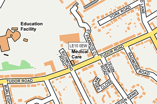
LE10 0EW lies on St Francis Close in Hinckley. LE10 0EW is located in the Hinckley De Montfort electoral ward, within the local authority district of Hinckley and Bosworth and the English Parliamentary constituency of Bosworth. The Sub Integrated Care Board (ICB) Location is NHS Leicester, Leicestershire and Rutland ICB - 04V and the police force is Leicestershire. This postcode has been in use since December 1999.


GetTheData
Source: OS OpenMap – Local (Ordnance Survey)
Source: OS VectorMap District (Ordnance Survey)
Licence: Open Government Licence (requires attribution)
| Easting | 442361 |
| Northing | 295095 |
| Latitude | 52.552058 |
| Longitude | -1.376679 |
GetTheData
Source: Open Postcode Geo
Licence: Open Government Licence
| Street | St Francis Close |
| Town/City | Hinckley |
| Country | England |
| Postcode District | LE10 |
➜ See where LE10 is on a map ➜ Where is Hinckley? | |
GetTheData
Source: Land Registry Price Paid Data
Licence: Open Government Licence
Elevation or altitude of LE10 0EW as distance above sea level:
| Metres | Feet | |
|---|---|---|
| Elevation | 120m | 394ft |
Elevation is measured from the approximate centre of the postcode, to the nearest point on an OS contour line from OS Terrain 50, which has contour spacing of ten vertical metres.
➜ How high above sea level am I? Find the elevation of your current position using your device's GPS.
GetTheData
Source: Open Postcode Elevation
Licence: Open Government Licence
| Ward | Hinckley De Montfort |
| Constituency | Bosworth |
GetTheData
Source: ONS Postcode Database
Licence: Open Government Licence
| St Francis Close (Tudor Road) | Hinckley | 46m |
| St Francis Close (Tudor Road) | Hinckley | 55m |
| Richmond Road (Tudor Road) | Hinckley | 132m |
| Radmore Road (Tudor Road) | Hinckley | 161m |
| Stanley Road | Hinckley | 178m |
| Hinckley Station | 1.9km |
GetTheData
Source: NaPTAN
Licence: Open Government Licence
GetTheData
Source: ONS Postcode Database
Licence: Open Government Licence


➜ Get more ratings from the Food Standards Agency
GetTheData
Source: Food Standards Agency
Licence: FSA terms & conditions
| Last Collection | |||
|---|---|---|---|
| Location | Mon-Fri | Sat | Distance |
| Tudor Road Post Office | 17:45 | 11:00 | 54m |
| Stanley Road | 17:30 | 11:00 | 368m |
| Cornfield | 18:30 | 11:30 | 491m |
GetTheData
Source: Dracos
Licence: Creative Commons Attribution-ShareAlike
The below table lists the International Territorial Level (ITL) codes (formerly Nomenclature of Territorial Units for Statistics (NUTS) codes) and Local Administrative Units (LAU) codes for LE10 0EW:
| ITL 1 Code | Name |
|---|---|
| TLF | East Midlands (England) |
| ITL 2 Code | Name |
| TLF2 | Leicestershire, Rutland and Northamptonshire |
| ITL 3 Code | Name |
| TLF22 | Leicestershire CC and Rutland |
| LAU 1 Code | Name |
| E07000132 | Hinckley and Bosworth |
GetTheData
Source: ONS Postcode Directory
Licence: Open Government Licence
The below table lists the Census Output Area (OA), Lower Layer Super Output Area (LSOA), and Middle Layer Super Output Area (MSOA) for LE10 0EW:
| Code | Name | |
|---|---|---|
| OA | E00131229 | |
| LSOA | E01025861 | Hinckley and Bosworth 009C |
| MSOA | E02005385 | Hinckley and Bosworth 009 |
GetTheData
Source: ONS Postcode Directory
Licence: Open Government Licence
| LE10 0DZ | Richmond Road | 44m |
| LE10 0EQ | Tudor Road | 121m |
| LE10 0PU | St Francis Close | 124m |
| LE10 0EF | Tudor Road | 132m |
| LE10 0EJ | Magee Close | 153m |
| LE10 0RH | York Road | 181m |
| LE10 0DN | Edward Street | 219m |
| LE10 0BW | Richmond Gate | 232m |
| LE10 0DJ | Edward Street | 236m |
| LE10 0HP | Stanley Road | 248m |
GetTheData
Source: Open Postcode Geo; Land Registry Price Paid Data
Licence: Open Government Licence