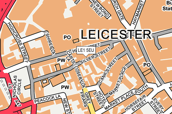
LE1 5EU lies on Silver Street in Leicester. LE1 5EU is located in the Castle electoral ward, within the unitary authority of Leicester and the English Parliamentary constituency of Leicester South. The Sub Integrated Care Board (ICB) Location is NHS Leicester, Leicestershire and Rutland ICB - 04C and the police force is Leicestershire. This postcode has been in use since January 1980.


GetTheData
Source: OS OpenMap – Local (Ordnance Survey)
Source: OS VectorMap District (Ordnance Survey)
Licence: Open Government Licence (requires attribution)
| Easting | 458591 |
| Northing | 304532 |
| Latitude | 52.635402 |
| Longitude | -1.135665 |
GetTheData
Source: Open Postcode Geo
Licence: Open Government Licence
| Street | Silver Street |
| Town/City | Leicester |
| Country | England |
| Postcode District | LE1 |
➜ See where LE1 is on a map ➜ Where is Leicester? | |
GetTheData
Source: Land Registry Price Paid Data
Licence: Open Government Licence
Elevation or altitude of LE1 5EU as distance above sea level:
| Metres | Feet | |
|---|---|---|
| Elevation | 60m | 197ft |
Elevation is measured from the approximate centre of the postcode, to the nearest point on an OS contour line from OS Terrain 50, which has contour spacing of ten vertical metres.
➜ How high above sea level am I? Find the elevation of your current position using your device's GPS.
GetTheData
Source: Open Postcode Elevation
Licence: Open Government Licence
| Ward | Castle |
| Constituency | Leicester South |
GetTheData
Source: ONS Postcode Database
Licence: Open Government Licence
| Church Gate | Leicester | 214m |
| Haymarket | Leicester | 233m |
| St Peter's Lane | Leicester | 234m |
| Town Hall Square (Horsefair Street) | Leicester | 238m |
| Town Hall Square (Horsefair Street) | Leicester | 243m |
| Leicester Station | 0.8km |
GetTheData
Source: NaPTAN
Licence: Open Government Licence
| Median download speed | 27.5Mbps |
| Average download speed | 41.3Mbps |
| Maximum download speed | 80.00Mbps |
| Median upload speed | 5.6Mbps |
| Average upload speed | 8.9Mbps |
| Maximum upload speed | 20.00Mbps |
GetTheData
Source: Ofcom
Licence: Ofcom Terms of Use (requires attribution)
GetTheData
Source: ONS Postcode Database
Licence: Open Government Licence


➜ Get more ratings from the Food Standards Agency
GetTheData
Source: Food Standards Agency
Licence: FSA terms & conditions
| Last Collection | |||
|---|---|---|---|
| Location | Mon-Fri | Sat | Distance |
| Greyfriars | 18:30 | 12:00 | 118m |
| St Nicholas Circle | 18:30 | 11:30 | 227m |
| Friar Lane | 18:30 | 12:00 | 259m |
GetTheData
Source: Dracos
Licence: Creative Commons Attribution-ShareAlike
The below table lists the International Territorial Level (ITL) codes (formerly Nomenclature of Territorial Units for Statistics (NUTS) codes) and Local Administrative Units (LAU) codes for LE1 5EU:
| ITL 1 Code | Name |
|---|---|
| TLF | East Midlands (England) |
| ITL 2 Code | Name |
| TLF2 | Leicestershire, Rutland and Northamptonshire |
| ITL 3 Code | Name |
| TLF21 | Leicester |
| LAU 1 Code | Name |
| E06000016 | Leicester |
GetTheData
Source: ONS Postcode Directory
Licence: Open Government Licence
The below table lists the Census Output Area (OA), Lower Layer Super Output Area (LSOA), and Middle Layer Super Output Area (MSOA) for LE1 5EU:
| Code | Name | |
|---|---|---|
| OA | E00169505 | |
| LSOA | E01032867 | Leicester 041A |
| MSOA | E02006851 | Leicester 041 |
GetTheData
Source: ONS Postcode Directory
Licence: Open Government Licence
| LE1 4FP | High Street | 51m |
| LE1 5DR | Loseby Lane | 64m |
| LE1 5DE | St Martins | 106m |
| LE1 5HJ | Odeon Arcade | 113m |
| LE1 5FQ | Guildhall Lane | 115m |
| LE1 5GF | Market Place | 115m |
| LE1 5YP | High Street | 117m |
| LE1 4JB | High Street | 123m |
| LE1 4AN | Shires Lane | 135m |
| LE1 5PH | Grey Friars | 152m |
GetTheData
Source: Open Postcode Geo; Land Registry Price Paid Data
Licence: Open Government Licence