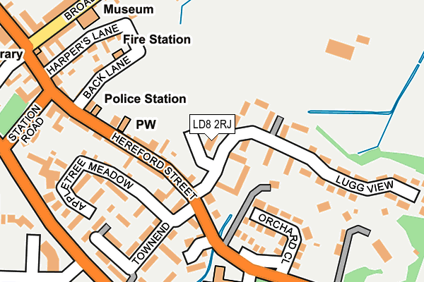
LD8 2RJ is located in the Presteigne electoral ward, within the unitary authority of Powys and the Welsh Parliamentary constituency of Brecon and Radnorshire. The Local Health Board is Powys Teaching and the police force is Dyfed-Powys. This postcode has been in use since June 2001.


GetTheData
Source: OS OpenMap – Local (Ordnance Survey)
Source: OS VectorMap District (Ordnance Survey)
Licence: Open Government Licence (requires attribution)
| Easting | 331687 |
| Northing | 264260 |
| Latitude | 52.272231 |
| Longitude | -3.002572 |
GetTheData
Source: Open Postcode Geo
Licence: Open Government Licence
| Country | Wales |
| Postcode District | LD8 |
➜ See where LD8 is on a map ➜ Where is Presteigne? | |
GetTheData
Source: Land Registry Price Paid Data
Licence: Open Government Licence
Elevation or altitude of LD8 2RJ as distance above sea level:
| Metres | Feet | |
|---|---|---|
| Elevation | 150m | 492ft |
Elevation is measured from the approximate centre of the postcode, to the nearest point on an OS contour line from OS Terrain 50, which has contour spacing of ten vertical metres.
➜ How high above sea level am I? Find the elevation of your current position using your device's GPS.
GetTheData
Source: Open Postcode Elevation
Licence: Open Government Licence
| Ward | Presteigne |
| Constituency | Brecon And Radnorshire |
GetTheData
Source: ONS Postcode Database
Licence: Open Government Licence
| Townend (Hereford Street) | Presteigne | 106m |
| Townend (Hereford Street) | Presteigne | 110m |
| Police Station (Hereford Street) | Presteigne | 175m |
| Police Station (Hereford Street) | Presteigne | 179m |
| Bank (Station Road) | Presteigne | 258m |
GetTheData
Source: NaPTAN
Licence: Open Government Licence
GetTheData
Source: ONS Postcode Database
Licence: Open Government Licence


➜ Get more ratings from the Food Standards Agency
GetTheData
Source: Food Standards Agency
Licence: FSA terms & conditions
| Last Collection | |||
|---|---|---|---|
| Location | Mon-Fri | Sat | Distance |
| Whitton Post Office | 16:15 | 11:30 | 5,499m |
GetTheData
Source: Dracos
Licence: Creative Commons Attribution-ShareAlike
The below table lists the International Territorial Level (ITL) codes (formerly Nomenclature of Territorial Units for Statistics (NUTS) codes) and Local Administrative Units (LAU) codes for LD8 2RJ:
| ITL 1 Code | Name |
|---|---|
| TLL | Wales |
| ITL 2 Code | Name |
| TLL2 | East Wales |
| ITL 3 Code | Name |
| TLL24 | Powys |
| LAU 1 Code | Name |
| W06000023 | Powys |
GetTheData
Source: ONS Postcode Directory
Licence: Open Government Licence
The below table lists the Census Output Area (OA), Lower Layer Super Output Area (LSOA), and Middle Layer Super Output Area (MSOA) for LD8 2RJ:
| Code | Name | |
|---|---|---|
| OA | W00002592 | |
| LSOA | W01000486 | Powys 011G |
| MSOA | W02000107 | Powys 011 |
GetTheData
Source: ONS Postcode Directory
Licence: Open Government Licence
| LD8 2AS | Hereford Street | 66m |
| LD8 2AR | Hereford Street | 104m |
| LD8 2DG | Lugg View | 138m |
| LD8 2AT | Hereford Street | 151m |
| LD8 2HF | Orchard Close | 157m |
| LD8 2DW | Townend | 170m |
| LD8 2AP | Back Lane | 199m |
| LD8 2AH | Harpers Lane | 205m |
| LD8 2AN | Harpers Lane | 207m |
| LD8 2DL | Appletree Meadow | 226m |
GetTheData
Source: Open Postcode Geo; Land Registry Price Paid Data
Licence: Open Government Licence