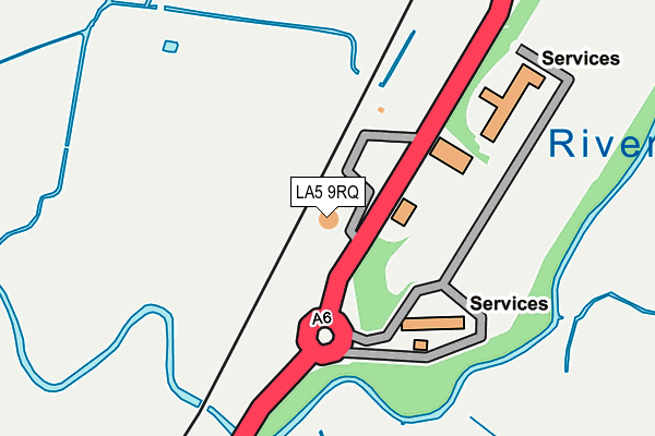
LA5 9RQ lies on Scotland Road in Carnforth. LA5 9RQ is located in the Warton electoral ward, within the local authority district of Lancaster and the English Parliamentary constituency of Morecambe and Lunesdale. The Sub Integrated Care Board (ICB) Location is NHS Lancashire and South Cumbria ICB - 01K and the police force is Lancashire. This postcode has been in use since January 1980.


GetTheData
Source: OS OpenMap – Local (Ordnance Survey)
Source: OS VectorMap District (Ordnance Survey)
Licence: Open Government Licence (requires attribution)
| Easting | 350594 |
| Northing | 471665 |
| Latitude | 54.138446 |
| Longitude | -2.757710 |
GetTheData
Source: Open Postcode Geo
Licence: Open Government Licence
| Street | Scotland Road |
| Town/City | Carnforth |
| Country | England |
| Postcode District | LA5 |
➜ See where LA5 is on a map | |
GetTheData
Source: Land Registry Price Paid Data
Licence: Open Government Licence
Elevation or altitude of LA5 9RQ as distance above sea level:
| Metres | Feet | |
|---|---|---|
| Elevation | 10m | 33ft |
Elevation is measured from the approximate centre of the postcode, to the nearest point on an OS contour line from OS Terrain 50, which has contour spacing of ten vertical metres.
➜ How high above sea level am I? Find the elevation of your current position using your device's GPS.
GetTheData
Source: Open Postcode Elevation
Licence: Open Government Licence
| Ward | Warton |
| Constituency | Morecambe And Lunesdale |
GetTheData
Source: ONS Postcode Database
Licence: Open Government Licence
| Pine Lakes (Scotland Road) | Carnforth | 460m |
| Malt Shovel (Main Street) | Warton | 939m |
| Carlisle Terrace (Warton Road) | Millhead | 949m |
| Carlisle Terrace (Warton Road) | Millhead | 958m |
| Malt Shovel (Main Street) | Warton | 961m |
| Carnforth Station | 1.3km |
| Silverdale Station | 4.6km |
GetTheData
Source: NaPTAN
Licence: Open Government Licence
GetTheData
Source: ONS Postcode Database
Licence: Open Government Licence


➜ Get more ratings from the Food Standards Agency
GetTheData
Source: Food Standards Agency
Licence: FSA terms & conditions
| Last Collection | |||
|---|---|---|---|
| Location | Mon-Fri | Sat | Distance |
| Millhead | 17:00 | 11:30 | 961m |
| North Road | 16:45 | 10:00 | 1,018m |
| Carnforth Post Office | 17:30 | 12:00 | 1,274m |
GetTheData
Source: Dracos
Licence: Creative Commons Attribution-ShareAlike
The below table lists the International Territorial Level (ITL) codes (formerly Nomenclature of Territorial Units for Statistics (NUTS) codes) and Local Administrative Units (LAU) codes for LA5 9RQ:
| ITL 1 Code | Name |
|---|---|
| TLD | North West (England) |
| ITL 2 Code | Name |
| TLD4 | Lancashire |
| ITL 3 Code | Name |
| TLD44 | Lancaster and Wyre |
| LAU 1 Code | Name |
| E07000121 | Lancaster |
GetTheData
Source: ONS Postcode Directory
Licence: Open Government Licence
The below table lists the Census Output Area (OA), Lower Layer Super Output Area (LSOA), and Middle Layer Super Output Area (MSOA) for LA5 9RQ:
| Code | Name | |
|---|---|---|
| OA | E00127743 | |
| LSOA | E01025169 | Lancaster 001G |
| MSOA | E02005221 | Lancaster 001 |
GetTheData
Source: ONS Postcode Directory
Licence: Open Government Licence
| LA5 9NG | North Road | 682m |
| LA5 9XT | Browfoot Close | 769m |
| LA5 9HG | Archer Hill | 802m |
| LA6 1AA | North Road | 806m |
| LA5 9HQ | Park View | 807m |
| LA5 9QT | Westover Road | 808m |
| LA5 9HF | Jackson Terrace | 840m |
| LA5 9XG | Coppice Brow | 845m |
| LA5 9XB | Redmayne Drive | 848m |
| LA5 9PQ | The Thoroughfare | 860m |
GetTheData
Source: Open Postcode Geo; Land Registry Price Paid Data
Licence: Open Government Licence