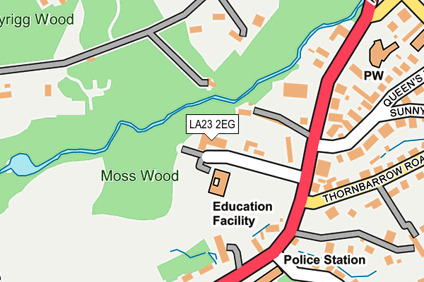
LA23 2EG lies on Goodly Dale in Windermere. LA23 2EG is located in the Windermere and Ambleside electoral ward, within the unitary authority of Westmorland and Furness and the English Parliamentary constituency of Westmorland and Lonsdale. The Sub Integrated Care Board (ICB) Location is NHS Lancashire and South Cumbria ICB - 01K and the police force is Cumbria. This postcode has been in use since January 1980.


GetTheData
Source: OS OpenMap – Local (Ordnance Survey)
Source: OS VectorMap District (Ordnance Survey)
Licence: Open Government Licence (requires attribution)
| Easting | 340756 |
| Northing | 497647 |
| Latitude | 54.370871 |
| Longitude | -2.913421 |
GetTheData
Source: Open Postcode Geo
Licence: Open Government Licence
| Street | Goodly Dale |
| Town/City | Windermere |
| Country | England |
| Postcode District | LA23 |
➜ See where LA23 is on a map ➜ Where is Windermere? | |
GetTheData
Source: Land Registry Price Paid Data
Licence: Open Government Licence
Elevation or altitude of LA23 2EG as distance above sea level:
| Metres | Feet | |
|---|---|---|
| Elevation | 80m | 262ft |
Elevation is measured from the approximate centre of the postcode, to the nearest point on an OS contour line from OS Terrain 50, which has contour spacing of ten vertical metres.
➜ How high above sea level am I? Find the elevation of your current position using your device's GPS.
GetTheData
Source: Open Postcode Elevation
Licence: Open Government Licence
| Ward | Windermere And Ambleside |
| Constituency | Westmorland And Lonsdale |
GetTheData
Source: ONS Postcode Database
Licence: Open Government Licence
| Goodly Dale (Lake Road) | Goodley Dale | 132m |
| Goodly Dale (Lake Road) | Goodley Dale | 156m |
| Beresford Road (Lake Road) | Bowness-on-windermere | 295m |
| Memorial (New Road) | Goodley Dale | 314m |
| Bank Road (Lake Road) | Bowness-on-windermere | 322m |
| Windermere Station | 1.2km |
GetTheData
Source: NaPTAN
Licence: Open Government Licence
GetTheData
Source: ONS Postcode Database
Licence: Open Government Licence


➜ Get more ratings from the Food Standards Agency
GetTheData
Source: Food Standards Agency
Licence: FSA terms & conditions
| Last Collection | |||
|---|---|---|---|
| Location | Mon-Fri | Sat | Distance |
| Beresford Road | 17:30 | 12:30 | 329m |
| Craig Walk | 17:30 | 12:30 | 464m |
| Brookside | 17:00 | 12:00 | 544m |
GetTheData
Source: Dracos
Licence: Creative Commons Attribution-ShareAlike
The below table lists the International Territorial Level (ITL) codes (formerly Nomenclature of Territorial Units for Statistics (NUTS) codes) and Local Administrative Units (LAU) codes for LA23 2EG:
| ITL 1 Code | Name |
|---|---|
| TLD | North West (England) |
| ITL 2 Code | Name |
| TLD1 | Cumbria |
| ITL 3 Code | Name |
| TLD12 | East Cumbria |
| LAU 1 Code | Name |
| E07000031 | South Lakeland |
GetTheData
Source: ONS Postcode Directory
Licence: Open Government Licence
The below table lists the Census Output Area (OA), Lower Layer Super Output Area (LSOA), and Middle Layer Super Output Area (MSOA) for LA23 2EG:
| Code | Name | |
|---|---|---|
| OA | E00098094 | |
| LSOA | E01019396 | South Lakeland 002B |
| MSOA | E02004016 | South Lakeland 002 |
GetTheData
Source: ONS Postcode Directory
Licence: Open Government Licence
| LA23 2JE | Lake Road | 153m |
| LA23 2JA | Lake Road | 155m |
| LA23 2JD | Lake Road | 163m |
| LA23 2EQ | Lake Road | 225m |
| LA23 2EW | Thornbarrow Road | 241m |
| LA23 2EL | Queens Drive | 249m |
| LA23 2JQ | South Craig | 266m |
| LA23 1DJ | Cornbirthwaite Road | 271m |
| LA23 2ES | Craig Walk | 284m |
| LA23 2EP | Thornbarrow Drive | 287m |
GetTheData
Source: Open Postcode Geo; Land Registry Price Paid Data
Licence: Open Government Licence