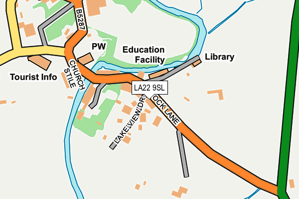
LA22 9SL lies on Stock Lane in Grasmere, Ambleside. LA22 9SL is located in the Windermere and Ambleside electoral ward, within the unitary authority of Westmorland and Furness and the English Parliamentary constituency of Westmorland and Lonsdale. The Sub Integrated Care Board (ICB) Location is NHS Lancashire and South Cumbria ICB - 01K and the police force is Cumbria. This postcode has been in use since January 1980.


GetTheData
Source: OS OpenMap – Local (Ordnance Survey)
Source: OS VectorMap District (Ordnance Survey)
Licence: Open Government Licence (requires attribution)
| Easting | 333863 |
| Northing | 507299 |
| Latitude | 54.456751 |
| Longitude | -3.021658 |
GetTheData
Source: Open Postcode Geo
Licence: Open Government Licence
| Street | Stock Lane |
| Locality | Grasmere |
| Town/City | Ambleside |
| Country | England |
| Postcode District | LA22 |
➜ See where LA22 is on a map ➜ Where is Grasmere? | |
GetTheData
Source: Land Registry Price Paid Data
Licence: Open Government Licence
Elevation or altitude of LA22 9SL as distance above sea level:
| Metres | Feet | |
|---|---|---|
| Elevation | 70m | 230ft |
Elevation is measured from the approximate centre of the postcode, to the nearest point on an OS contour line from OS Terrain 50, which has contour spacing of ten vertical metres.
➜ How high above sea level am I? Find the elevation of your current position using your device's GPS.
GetTheData
Source: Open Postcode Elevation
Licence: Open Government Licence
| Ward | Windermere And Ambleside |
| Constituency | Westmorland And Lonsdale |
GetTheData
Source: ONS Postcode Database
Licence: Open Government Licence
| School (Stock Lane) | Grasmere | 24m |
| School (Stock Lane) | Grasmere | 26m |
| Stock Lane Car Park (Stock Lane) | Grasmere | 92m |
| Heaton Cooper Studio (Broadgate) | Grasmere | 354m |
| Heaton Copper Studio (Broadgate) | Grasmere | 393m |
GetTheData
Source: NaPTAN
Licence: Open Government Licence
GetTheData
Source: ONS Postcode Database
Licence: Open Government Licence


➜ Get more ratings from the Food Standards Agency
GetTheData
Source: Food Standards Agency
Licence: FSA terms & conditions
| Last Collection | |||
|---|---|---|---|
| Location | Mon-Fri | Sat | Distance |
| Grasmere Post Office | 16:45 | 12:00 | 320m |
| Town End | 16:45 | 12:00 | 450m |
| White Bridge | 16:30 | 09:00 | 791m |
GetTheData
Source: Dracos
Licence: Creative Commons Attribution-ShareAlike
| Risk of LA22 9SL flooding from rivers and sea | Medium |
| ➜ LA22 9SL flood map | |
GetTheData
Source: Open Flood Risk by Postcode
Licence: Open Government Licence
The below table lists the International Territorial Level (ITL) codes (formerly Nomenclature of Territorial Units for Statistics (NUTS) codes) and Local Administrative Units (LAU) codes for LA22 9SL:
| ITL 1 Code | Name |
|---|---|
| TLD | North West (England) |
| ITL 2 Code | Name |
| TLD1 | Cumbria |
| ITL 3 Code | Name |
| TLD12 | East Cumbria |
| LAU 1 Code | Name |
| E07000031 | South Lakeland |
GetTheData
Source: ONS Postcode Directory
Licence: Open Government Licence
The below table lists the Census Output Area (OA), Lower Layer Super Output Area (LSOA), and Middle Layer Super Output Area (MSOA) for LA22 9SL:
| Code | Name | |
|---|---|---|
| OA | E00097964 | |
| LSOA | E01019376 | South Lakeland 001C |
| MSOA | E02004015 | South Lakeland 001 |
GetTheData
Source: ONS Postcode Directory
Licence: Open Government Licence
| LA22 9SJ | Stock Lane | 26m |
| LA22 9TD | Lake View Drive | 74m |
| LA22 9SN | Broadgate | 103m |
| LA22 9SP | Red Lion Square | 302m |
| LA22 9QS | Parrock Mews | 305m |
| LA22 9SZ | College Street | 308m |
| LA22 9ST | Red Lion Cottages | 328m |
| LA22 9QY | 334m | |
| LA22 9SU | 335m | |
| LA22 9SY | Beck Steps | 349m |
GetTheData
Source: Open Postcode Geo; Land Registry Price Paid Data
Licence: Open Government Licence