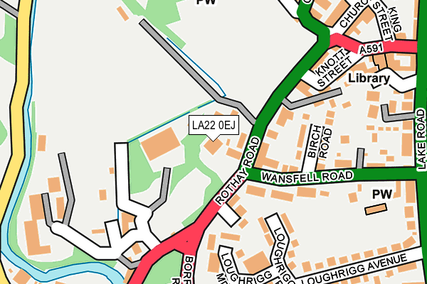
LA22 0EJ is located in the Windermere and Ambleside electoral ward, within the unitary authority of Westmorland and Furness and the English Parliamentary constituency of Westmorland and Lonsdale. The Sub Integrated Care Board (ICB) Location is NHS Lancashire and South Cumbria ICB - 01K and the police force is Cumbria. This postcode has been in use since December 1998.


GetTheData
Source: OS OpenMap – Local (Ordnance Survey)
Source: OS VectorMap District (Ordnance Survey)
Licence: Open Government Licence (requires attribution)
| Easting | 337374 |
| Northing | 504129 |
| Latitude | 54.428712 |
| Longitude | -2.966839 |
GetTheData
Source: Open Postcode Geo
Licence: Open Government Licence
| Country | England |
| Postcode District | LA22 |
➜ See where LA22 is on a map ➜ Where is Ambleside? | |
GetTheData
Source: Land Registry Price Paid Data
Licence: Open Government Licence
Elevation or altitude of LA22 0EJ as distance above sea level:
| Metres | Feet | |
|---|---|---|
| Elevation | 50m | 164ft |
Elevation is measured from the approximate centre of the postcode, to the nearest point on an OS contour line from OS Terrain 50, which has contour spacing of ten vertical metres.
➜ How high above sea level am I? Find the elevation of your current position using your device's GPS.
GetTheData
Source: Open Postcode Elevation
Licence: Open Government Licence
| Ward | Windermere And Ambleside |
| Constituency | Westmorland And Lonsdale |
GetTheData
Source: ONS Postcode Database
Licence: Open Government Licence
| Rydal Road Bowling Green (Rydal Road) | Ambleside | 122m |
| Riverside Lodge (Borrans Road) | Ambleside | 197m |
| Bus Interchange (Kelsick Road) | Ambleside | 254m |
| Bus Interchange (Kelsick Road) | Ambleside | 272m |
| Loughrigg Avenue (Lake Road) | Ambleside | 310m |
GetTheData
Source: NaPTAN
Licence: Open Government Licence
GetTheData
Source: ONS Postcode Database
Licence: Open Government Licence


➜ Get more ratings from the Food Standards Agency
GetTheData
Source: Food Standards Agency
Licence: FSA terms & conditions
| Last Collection | |||
|---|---|---|---|
| Location | Mon-Fri | Sat | Distance |
| Rothay Bridge | 17:00 | 11:45 | 101m |
| Lake Road, Ambleside | 17:00 | 11:45 | 297m |
| Under Loughrigg | 15:15 | 08:00 | 331m |
GetTheData
Source: Dracos
Licence: Creative Commons Attribution-ShareAlike
The below table lists the International Territorial Level (ITL) codes (formerly Nomenclature of Territorial Units for Statistics (NUTS) codes) and Local Administrative Units (LAU) codes for LA22 0EJ:
| ITL 1 Code | Name |
|---|---|
| TLD | North West (England) |
| ITL 2 Code | Name |
| TLD1 | Cumbria |
| ITL 3 Code | Name |
| TLD12 | East Cumbria |
| LAU 1 Code | Name |
| E07000031 | South Lakeland |
GetTheData
Source: ONS Postcode Directory
Licence: Open Government Licence
The below table lists the Census Output Area (OA), Lower Layer Super Output Area (LSOA), and Middle Layer Super Output Area (MSOA) for LA22 0EJ:
| Code | Name | |
|---|---|---|
| OA | E00097954 | |
| LSOA | E01019375 | South Lakeland 001B |
| MSOA | E02004015 | South Lakeland 001 |
GetTheData
Source: ONS Postcode Directory
Licence: Open Government Licence
| LA22 0EE | Rothay Road | 43m |
| LA22 0EQ | Birch Road | 155m |
| LA22 0RB | Reed Bottoms | 175m |
| LA22 0DZ | Loughrigg Meadow | 180m |
| LA22 0DY | Loughrigg Park | 204m |
| LA22 0EG | Wansfell Road | 214m |
| LA22 0EH | Rothay Road | 222m |
| LA22 9DL | Cambridge Villas | 244m |
| LA22 0DG | Loughrigg Avenue | 265m |
| LA22 0BT | Church Street | 268m |
GetTheData
Source: Open Postcode Geo; Land Registry Price Paid Data
Licence: Open Government Licence