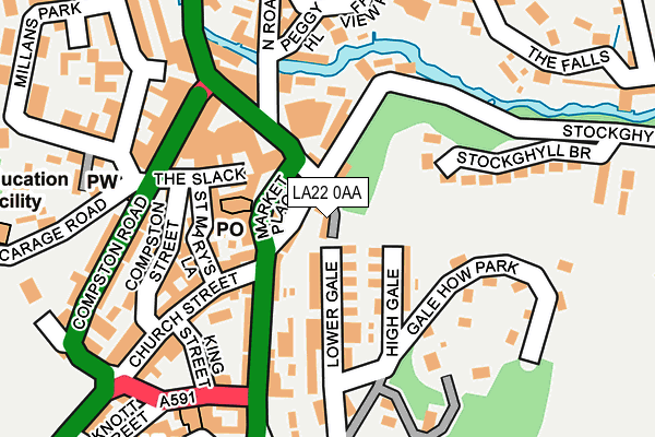
LA22 0AA lies on Gale Terrace in Ambleside. LA22 0AA is located in the Windermere and Ambleside electoral ward, within the unitary authority of Westmorland and Furness and the English Parliamentary constituency of Westmorland and Lonsdale. The Sub Integrated Care Board (ICB) Location is NHS Lancashire and South Cumbria ICB - 01K and the police force is Cumbria. This postcode has been in use since January 1980.


GetTheData
Source: OS OpenMap – Local (Ordnance Survey)
Source: OS VectorMap District (Ordnance Survey)
Licence: Open Government Licence (requires attribution)
| Easting | 337731 |
| Northing | 504425 |
| Latitude | 54.431423 |
| Longitude | -2.961403 |
GetTheData
Source: Open Postcode Geo
Licence: Open Government Licence
| Street | Gale Terrace |
| Town/City | Ambleside |
| Country | England |
| Postcode District | LA22 |
➜ See where LA22 is on a map ➜ Where is Ambleside? | |
GetTheData
Source: Land Registry Price Paid Data
Licence: Open Government Licence
Elevation or altitude of LA22 0AA as distance above sea level:
| Metres | Feet | |
|---|---|---|
| Elevation | 70m | 230ft |
Elevation is measured from the approximate centre of the postcode, to the nearest point on an OS contour line from OS Terrain 50, which has contour spacing of ten vertical metres.
➜ How high above sea level am I? Find the elevation of your current position using your device's GPS.
GetTheData
Source: Open Postcode Elevation
Licence: Open Government Licence
| Ward | Windermere And Ambleside |
| Constituency | Westmorland And Lonsdale |
GetTheData
Source: ONS Postcode Database
Licence: Open Government Licence
| Salutation Hotel (Lake Road) | Ambleside | 79m |
| Bus Interchange (Kelsick Road) | Ambleside | 200m |
| Bus Interchange (Kelsick Road) | Ambleside | 214m |
| Loughrigg Avenue (Lake Road) | Ambleside | 408m |
| Rydal Road Health Centre (Rydal Road) | Ambleside | 493m |
GetTheData
Source: NaPTAN
Licence: Open Government Licence
| Percentage of properties with Next Generation Access | 100.0% |
| Percentage of properties with Superfast Broadband | 100.0% |
| Percentage of properties with Ultrafast Broadband | 0.0% |
| Percentage of properties with Full Fibre Broadband | 0.0% |
Superfast Broadband is between 30Mbps and 300Mbps
Ultrafast Broadband is > 300Mbps
| Median download speed | 32.2Mbps |
| Average download speed | 37.1Mbps |
| Maximum download speed | 80.00Mbps |
| Median upload speed | 10.0Mbps |
| Average upload speed | 8.1Mbps |
| Maximum upload speed | 17.95Mbps |
| Percentage of properties unable to receive 2Mbps | 0.0% |
| Percentage of properties unable to receive 5Mbps | 0.0% |
| Percentage of properties unable to receive 10Mbps | 0.0% |
| Percentage of properties unable to receive 30Mbps | 0.0% |
GetTheData
Source: Ofcom
Licence: Ofcom Terms of Use (requires attribution)
GetTheData
Source: ONS Postcode Database
Licence: Open Government Licence


➜ Get more ratings from the Food Standards Agency
GetTheData
Source: Food Standards Agency
Licence: FSA terms & conditions
| Last Collection | |||
|---|---|---|---|
| Location | Mon-Fri | Sat | Distance |
| Ambleside Post Office | 17:30 | 12:30 | 120m |
| Ambleside Post Office | 17:30 | 12:30 | 120m |
| Millans Park | 17:00 | 11:45 | 170m |
GetTheData
Source: Dracos
Licence: Creative Commons Attribution-ShareAlike
The below table lists the International Territorial Level (ITL) codes (formerly Nomenclature of Territorial Units for Statistics (NUTS) codes) and Local Administrative Units (LAU) codes for LA22 0AA:
| ITL 1 Code | Name |
|---|---|
| TLD | North West (England) |
| ITL 2 Code | Name |
| TLD1 | Cumbria |
| ITL 3 Code | Name |
| TLD12 | East Cumbria |
| LAU 1 Code | Name |
| E07000031 | South Lakeland |
GetTheData
Source: ONS Postcode Directory
Licence: Open Government Licence
The below table lists the Census Output Area (OA), Lower Layer Super Output Area (LSOA), and Middle Layer Super Output Area (MSOA) for LA22 0AA:
| Code | Name | |
|---|---|---|
| OA | E00097949 | |
| LSOA | E01019375 | South Lakeland 001B |
| MSOA | E02004015 | South Lakeland 001 |
GetTheData
Source: ONS Postcode Directory
Licence: Open Government Licence
| LA22 9BU | Market Place | 45m |
| LA22 0BJ | High Gale | 91m |
| LA22 9DQ | The Slack | 100m |
| LA22 9DG | St Marys Lane | 107m |
| LA22 0BG | High Gale | 108m |
| LA22 0BD | Lower Gale | 120m |
| LA22 0AD | Lake Road | 128m |
| LA22 9BT | Market Cross | 133m |
| LA22 0BU | Church Street | 140m |
| LA22 0ET | Lakelands | 144m |
GetTheData
Source: Open Postcode Geo; Land Registry Price Paid Data
Licence: Open Government Licence