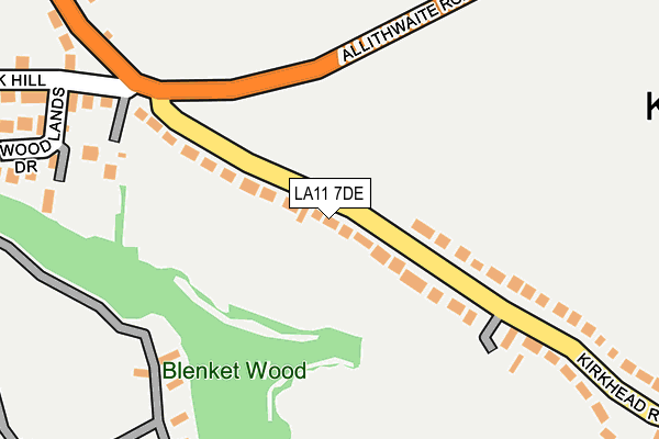
LA11 7DE is located in the Grange and Cartmel electoral ward, within the unitary authority of Westmorland and Furness and the English Parliamentary constituency of Westmorland and Lonsdale. The Sub Integrated Care Board (ICB) Location is NHS Lancashire and South Cumbria ICB - 01K and the police force is Cumbria. This postcode has been in use since July 2017.


GetTheData
Source: OS OpenMap – Local (Ordnance Survey)
Source: OS VectorMap District (Ordnance Survey)
Licence: Open Government Licence (requires attribution)
| Easting | 340333 |
| Northing | 477089 |
| Latitude | 54.186096 |
| Longitude | -2.915823 |
GetTheData
Source: Open Postcode Geo
Licence: Open Government Licence
| Country | England |
| Postcode District | LA11 |
➜ See where LA11 is on a map ➜ Where is Grange-over-Sands? | |
GetTheData
Source: Land Registry Price Paid Data
Licence: Open Government Licence
| Ward | Grange And Cartmel |
| Constituency | Westmorland And Lonsdale |
GetTheData
Source: ONS Postcode Database
Licence: Open Government Licence
56, TRICKETTS DRIVE, GRANGE-OVER-SANDS, LA11 7DE 2023 22 NOV £415,000 |
19, TRICKETTS DRIVE, GRANGE-OVER-SANDS, LA11 7DE 2023 3 FEB £425,000 |
57, TRICKETTS DRIVE, GRANGE-OVER-SANDS, LA11 7DE 2021 2 DEC £385,000 |
18, TRICKETTS DRIVE, GRANGE-OVER-SANDS, LA11 7DE 2021 30 JUN £380,000 |
54, TRICKETTS DRIVE, GRANGE-OVER-SANDS, LA11 7DE 2020 14 DEC £374,000 |
55, TRICKETTS DRIVE, GRANGE-OVER-SANDS, LA11 7DE 2020 5 JUN £425,000 |
23, TRICKETTS DRIVE, GRANGE-OVER-SANDS, LA11 7DE 2018 5 OCT £409,950 |
27, TRICKETTS DRIVE, GRANGE-OVER-SANDS, LA11 7DE 2018 31 AUG £309,950 |
18, TRICKETTS DRIVE, GRANGE-OVER-SANDS, LA11 7DE 2018 17 MAY £342,950 |
22, TRICKETTS DRIVE, GRANGE-OVER-SANDS, LA11 7DE 2018 11 MAY £399,950 |
➜ Grange-over-Sands house prices
GetTheData
Source: HM Land Registry Price Paid Data
Licence: Contains HM Land Registry data © Crown copyright and database right 2024. This data is licensed under the Open Government Licence v3.0.
| Fire Station (Kents Bank Road) | Grange-over-sands | 171m |
| Greenlea (Kents Bank Road) | Grange-over-sands | 181m |
| Greenlea (Kents Bank Road) | Grange-over-sands | 187m |
| Berners Close (Kents Bank Road) | Grange-over-sands | 199m |
| Silver How (Kents Bank Road) | Grange-over-sands | 329m |
| Grange-over-Sands Station | 1.4km |
| Kents Bank Station | 1.6km |
| Cark Station | 3.9km |
GetTheData
Source: NaPTAN
Licence: Open Government Licence
| Percentage of properties with Next Generation Access | 100.0% |
| Percentage of properties with Superfast Broadband | 100.0% |
| Percentage of properties with Ultrafast Broadband | 0.0% |
| Percentage of properties with Full Fibre Broadband | 0.0% |
Superfast Broadband is between 30Mbps and 300Mbps
Ultrafast Broadband is > 300Mbps
| Median download speed | 50.4Mbps |
| Average download speed | 44.6Mbps |
| Maximum download speed | 80.00Mbps |
| Median upload speed | 10.0Mbps |
| Average upload speed | 10.8Mbps |
| Maximum upload speed | 20.00Mbps |
| Percentage of properties unable to receive 2Mbps | 0.0% |
| Percentage of properties unable to receive 5Mbps | 0.0% |
| Percentage of properties unable to receive 10Mbps | 0.0% |
| Percentage of properties unable to receive 30Mbps | 0.0% |
GetTheData
Source: Ofcom
Licence: Ofcom Terms of Use (requires attribution)
GetTheData
Source: ONS Postcode Database
Licence: Open Government Licence


➜ Get more ratings from the Food Standards Agency
GetTheData
Source: Food Standards Agency
Licence: FSA terms & conditions
| Last Collection | |||
|---|---|---|---|
| Location | Mon-Fri | Sat | Distance |
| Main Street | 16:15 | 11:45 | 1,053m |
| Windermere Road | 16:30 | 11:45 | 1,375m |
| Slack | 16:15 | 10:30 | 2,126m |
GetTheData
Source: Dracos
Licence: Creative Commons Attribution-ShareAlike
The below table lists the International Territorial Level (ITL) codes (formerly Nomenclature of Territorial Units for Statistics (NUTS) codes) and Local Administrative Units (LAU) codes for LA11 7DE:
| ITL 1 Code | Name |
|---|---|
| TLD | North West (England) |
| ITL 2 Code | Name |
| TLD1 | Cumbria |
| ITL 3 Code | Name |
| TLD12 | East Cumbria |
| LAU 1 Code | Name |
| E07000031 | South Lakeland |
GetTheData
Source: ONS Postcode Directory
Licence: Open Government Licence
The below table lists the Census Output Area (OA), Lower Layer Super Output Area (LSOA), and Middle Layer Super Output Area (MSOA) for LA11 7DE:
| Code | Name | |
|---|---|---|
| OA | E00097820 | |
| LSOA | E01019353 | South Lakeland 013B |
| MSOA | E02004027 | South Lakeland 013 |
GetTheData
Source: ONS Postcode Directory
Licence: Open Government Licence
| LA11 7DT | Kents Bank Road | 92m |
| LA11 7DR | Thornfield Road | 99m |
| LA11 7DW | Mayfield Terrace | 127m |
| LA11 7DP | Methven Terrace | 146m |
| LA11 7DX | Methven Close | 179m |
| LA11 7DJ | Kents Bank Road | 208m |
| LA11 7DQ | Berners Close | 219m |
| LA11 7EE | The Heads | 221m |
| LA11 7EF | Kents Bank Road | 249m |
| LA11 7AA | Yew Tree Road | 255m |
GetTheData
Source: Open Postcode Geo; Land Registry Price Paid Data
Licence: Open Government Licence