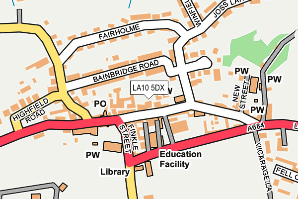
LA10 5DX is located in the Sedbergh and Kirkby Lonsdale electoral ward, within the unitary authority of Westmorland and Furness and the English Parliamentary constituency of Westmorland and Lonsdale. The Sub Integrated Care Board (ICB) Location is NHS Lancashire and South Cumbria ICB - 01K and the police force is Cumbria. This postcode has been in use since January 1980.


GetTheData
Source: OS OpenMap – Local (Ordnance Survey)
Source: OS VectorMap District (Ordnance Survey)
Licence: Open Government Licence (requires attribution)
| Easting | 365798 |
| Northing | 492168 |
| Latitude | 54.323934 |
| Longitude | -2.527354 |
GetTheData
Source: Open Postcode Geo
Licence: Open Government Licence
| Country | England |
| Postcode District | LA10 |
➜ See where LA10 is on a map ➜ Where is Sedbergh? | |
GetTheData
Source: Land Registry Price Paid Data
Licence: Open Government Licence
Elevation or altitude of LA10 5DX as distance above sea level:
| Metres | Feet | |
|---|---|---|
| Elevation | 130m | 427ft |
Elevation is measured from the approximate centre of the postcode, to the nearest point on an OS contour line from OS Terrain 50, which has contour spacing of ten vertical metres.
➜ How high above sea level am I? Find the elevation of your current position using your device's GPS.
GetTheData
Source: Open Postcode Elevation
Licence: Open Government Licence
| Ward | Sedbergh And Kirkby Lonsdale |
| Constituency | Westmorland And Lonsdale |
GetTheData
Source: ONS Postcode Database
Licence: Open Government Licence
| Library (Main Street) | Sedbergh | 96m |
| Joss Lane (Main Street) | Sedbergh | 104m |
| The Dalesman (Main Street) | Sedbergh | 122m |
| Loftus Hill | Sedbergh | 321m |
| Settlebeck School (Long Lane) | Sedbergh | 382m |
GetTheData
Source: NaPTAN
Licence: Open Government Licence
GetTheData
Source: ONS Postcode Database
Licence: Open Government Licence


➜ Get more ratings from the Food Standards Agency
GetTheData
Source: Food Standards Agency
Licence: FSA terms & conditions
| Last Collection | |||
|---|---|---|---|
| Location | Mon-Fri | Sat | Distance |
| Fairholme | 17:00 | 12:00 | 155m |
| Settlebeck | 17:00 | 11:15 | 399m |
| Loftus Hill | 16:45 | 12:00 | 542m |
GetTheData
Source: Dracos
Licence: Creative Commons Attribution-ShareAlike
The below table lists the International Territorial Level (ITL) codes (formerly Nomenclature of Territorial Units for Statistics (NUTS) codes) and Local Administrative Units (LAU) codes for LA10 5DX:
| ITL 1 Code | Name |
|---|---|
| TLD | North West (England) |
| ITL 2 Code | Name |
| TLD1 | Cumbria |
| ITL 3 Code | Name |
| TLD12 | East Cumbria |
| LAU 1 Code | Name |
| E07000031 | South Lakeland |
GetTheData
Source: ONS Postcode Directory
Licence: Open Government Licence
The below table lists the Census Output Area (OA), Lower Layer Super Output Area (LSOA), and Middle Layer Super Output Area (MSOA) for LA10 5DX:
| Code | Name | |
|---|---|---|
| OA | E00098013 | |
| LSOA | E01019385 | South Lakeland 009D |
| MSOA | E02004023 | South Lakeland 009 |
GetTheData
Source: ONS Postcode Directory
Licence: Open Government Licence
| LA10 5BL | Main Street | 39m |
| LA10 5BQ | Kings Court | 48m |
| LA10 5EA | Bainbridge Court | 58m |
| LA10 5AB | Main Street | 65m |
| LA10 5BD | Railton Yard | 67m |
| LA10 5BB | Davis Yard | 69m |
| LA10 5BJ | Kings Yard | 76m |
| LA10 5BU | Weavers Court | 77m |
| LA10 5BZ | Finkle Street | 89m |
| LA10 5AU | Bainbridge Road | 94m |
GetTheData
Source: Open Postcode Geo; Land Registry Price Paid Data
Licence: Open Government Licence