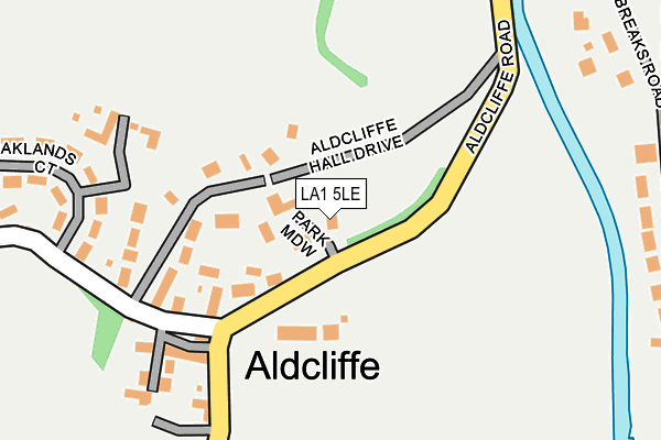
LA1 5LE is located in the Scotforth West electoral ward, within the local authority district of Lancaster and the English Parliamentary constituency of Lancaster and Fleetwood. The Sub Integrated Care Board (ICB) Location is NHS Lancashire and South Cumbria ICB - 01K and the police force is Lancashire. This postcode has been in use since April 2017.


GetTheData
Source: OS OpenMap – Local (Ordnance Survey)
Source: OS VectorMap District (Ordnance Survey)
Licence: Open Government Licence (requires attribution)
| Easting | 346762 |
| Northing | 460225 |
| Latitude | 54.035256 |
| Longitude | -2.814338 |
GetTheData
Source: Open Postcode Geo
Licence: Open Government Licence
| Country | England |
| Postcode District | LA1 |
➜ See where LA1 is on a map | |
GetTheData
Source: Land Registry Price Paid Data
Licence: Open Government Licence
| Ward | Scotforth West |
| Constituency | Lancaster And Fleetwood |
GetTheData
Source: ONS Postcode Database
Licence: Open Government Licence
| Aldcliffe Hall Drive (Aldcliffe Hall Lane) | Aldcliffe | 159m |
| Islamic College (Ashton Road) | Haverbreaks | 804m |
| Islamic College (Ashton Road) | Haverbreaks | 816m |
| Bridge Road (Ashton Road) | Greaves | 863m |
| Bridge Road (Ashton Road) | Greaves | 873m |
| Lancaster Station | 1.6km |
| Bare Lane Station | 4.6km |
| Morecambe Station | 5.3km |
GetTheData
Source: NaPTAN
Licence: Open Government Licence
| Percentage of properties with Next Generation Access | 100.0% |
| Percentage of properties with Superfast Broadband | 100.0% |
| Percentage of properties with Ultrafast Broadband | 0.0% |
| Percentage of properties with Full Fibre Broadband | 0.0% |
Superfast Broadband is between 30Mbps and 300Mbps
Ultrafast Broadband is > 300Mbps
| Percentage of properties unable to receive 2Mbps | 0.0% |
| Percentage of properties unable to receive 5Mbps | 0.0% |
| Percentage of properties unable to receive 10Mbps | 0.0% |
| Percentage of properties unable to receive 30Mbps | 0.0% |
GetTheData
Source: Ofcom
Licence: Ofcom Terms of Use (requires attribution)
GetTheData
Source: ONS Postcode Database
Licence: Open Government Licence


➜ Get more ratings from the Food Standards Agency
GetTheData
Source: Food Standards Agency
Licence: FSA terms & conditions
| Last Collection | |||
|---|---|---|---|
| Location | Mon-Fri | Sat | Distance |
| Aldcliffe Village | 16:15 | 07:30 | 223m |
| Haverbreaks | 16:15 | 12:00 | 600m |
| 42 Aldcliffe Road | 16:15 | 12:00 | 713m |
GetTheData
Source: Dracos
Licence: Creative Commons Attribution-ShareAlike
The below table lists the International Territorial Level (ITL) codes (formerly Nomenclature of Territorial Units for Statistics (NUTS) codes) and Local Administrative Units (LAU) codes for LA1 5LE:
| ITL 1 Code | Name |
|---|---|
| TLD | North West (England) |
| ITL 2 Code | Name |
| TLD4 | Lancashire |
| ITL 3 Code | Name |
| TLD44 | Lancaster and Wyre |
| LAU 1 Code | Name |
| E07000121 | Lancaster |
GetTheData
Source: ONS Postcode Directory
Licence: Open Government Licence
The below table lists the Census Output Area (OA), Lower Layer Super Output Area (LSOA), and Middle Layer Super Output Area (MSOA) for LA1 5LE:
| Code | Name | |
|---|---|---|
| OA | E00127387 | |
| LSOA | E01025103 | Lancaster 017D |
| MSOA | E02005237 | Lancaster 017 |
GetTheData
Source: ONS Postcode Directory
Licence: Open Government Licence
| LA1 5AR | 70m | |
| LA1 5BG | 99m | |
| LA1 5AP | 102m | |
| LA1 5BQ | Aldcliffe Cottages | 142m |
| LA1 5BT | Aldcliffe Mews | 190m |
| LA1 5AX | Oaklands Court | 206m |
| LA1 5AS | 242m | |
| LA1 5AT | Oaklands Court | 252m |
| LA1 5BJ | Haverbreaks Road | 371m |
| LA1 5AU | Craiglands Court | 395m |
GetTheData
Source: Open Postcode Geo; Land Registry Price Paid Data
Licence: Open Government Licence