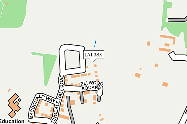
LA1 3SX is located in the Bulk electoral ward, within the local authority district of Lancaster and the English Parliamentary constituency of Lancaster and Fleetwood. The Sub Integrated Care Board (ICB) Location is NHS Lancashire and South Cumbria ICB - 01K and the police force is Lancashire. This postcode has been in use since May 2017.


GetTheData
Source: OS OpenMap – Local (Ordnance Survey)
Source: OS VectorMap District (Ordnance Survey)
Licence: Open Government Licence (requires attribution)
| Easting | 349006 |
| Northing | 461924 |
| Latitude | 54.050751 |
| Longitude | -2.780366 |
GetTheData
Source: Open Postcode Geo
Licence: Open Government Licence
| Country | England |
| Postcode District | LA1 |
➜ See where LA1 is on a map ➜ Where is Lancaster? | |
GetTheData
Source: Land Registry Price Paid Data
Licence: Open Government Licence
| Ward | Bulk |
| Constituency | Lancaster And Fleetwood |
GetTheData
Source: ONS Postcode Database
Licence: Open Government Licence
2024 12 JAN £370,000 |
2022 31 AUG £385,000 |
2021 23 APR £315,000 |
2020 31 JAN £320,000 |
23, DENNISON CLOSE, LANCASTER, LA1 3SX 2018 7 DEC £309,995 |
2018 19 OCT £354,995 |
2018 28 SEP £309,995 |
19, DENNISON CLOSE, LANCASTER, LA1 3SX 2018 28 SEP £359,995 |
17, DENNISON CLOSE, LANCASTER, LA1 3SX 2018 2 AUG £359,995 |
15, DENNISON CLOSE, LANCASTER, LA1 3SX 2018 27 JUL £309,995 |
GetTheData
Source: HM Land Registry Price Paid Data
Licence: Contains HM Land Registry data © Crown copyright and database right 2024. This data is licensed under the Open Government Licence v3.0.
| Williamsons Park (Quernmore Road) | Standen Gate | 291m |
| Williamsons Park (Quernmore Road) | Standen Gate | 314m |
| Parkgate Drive (Quernmore Road) | Standen Gate | 327m |
| Parkgate Drive (Quernmore Road) | Standen Gate | 332m |
| Ridge Lea Hospital (Stone Row Head) | Standen Gate | 385m |
| Lancaster Station | 1.8km |
| Bare Lane Station | 4.5km |
GetTheData
Source: NaPTAN
Licence: Open Government Licence
| Percentage of properties with Next Generation Access | 100.0% |
| Percentage of properties with Superfast Broadband | 100.0% |
| Percentage of properties with Ultrafast Broadband | 97.3% |
| Percentage of properties with Full Fibre Broadband | 97.3% |
Superfast Broadband is between 30Mbps and 300Mbps
Ultrafast Broadband is > 300Mbps
| Percentage of properties unable to receive 2Mbps | 0.0% |
| Percentage of properties unable to receive 5Mbps | 0.0% |
| Percentage of properties unable to receive 10Mbps | 0.0% |
| Percentage of properties unable to receive 30Mbps | 0.0% |
GetTheData
Source: Ofcom
Licence: Ofcom Terms of Use (requires attribution)
GetTheData
Source: ONS Postcode Database
Licence: Open Government Licence


➜ Get more ratings from the Food Standards Agency
GetTheData
Source: Food Standards Agency
Licence: FSA terms & conditions
| Last Collection | |||
|---|---|---|---|
| Location | Mon-Fri | Sat | Distance |
| 30 Windermere Road | 16:00 | 12:00 | 479m |
| Quernmore Road | 16:00 | 12:15 | 587m |
| Ridge Post Office | 16:00 | 12:00 | 714m |
GetTheData
Source: Dracos
Licence: Creative Commons Attribution-ShareAlike
The below table lists the International Territorial Level (ITL) codes (formerly Nomenclature of Territorial Units for Statistics (NUTS) codes) and Local Administrative Units (LAU) codes for LA1 3SX:
| ITL 1 Code | Name |
|---|---|
| TLD | North West (England) |
| ITL 2 Code | Name |
| TLD4 | Lancashire |
| ITL 3 Code | Name |
| TLD44 | Lancaster and Wyre |
| LAU 1 Code | Name |
| E07000121 | Lancaster |
GetTheData
Source: ONS Postcode Directory
Licence: Open Government Licence
The below table lists the Census Output Area (OA), Lower Layer Super Output Area (LSOA), and Middle Layer Super Output Area (MSOA) for LA1 3SX:
| Code | Name | |
|---|---|---|
| OA | E00127356 | |
| LSOA | E01025095 | Lancaster 013C |
| MSOA | E02005233 | Lancaster 013 |
GetTheData
Source: ONS Postcode Directory
Licence: Open Government Licence
| LA1 3JU | Willow Grove | 117m |
| LA1 3SZ | Nightingale Hall Road | 120m |
| LA1 3JT | Quernmore Road | 177m |
| LA1 3TA | Macdonald Way | 194m |
| LA1 3ET | Lunesdale Court | 363m |
| LA1 3FN | Parkgate Drive | 385m |
| LA1 3ES | Derwent Road | 406m |
| LA1 3RG | Esthwaite Gardens | 437m |
| LA1 3EY | Dalton Road | 441m |
| LA1 3EX | Windermere Road | 484m |
GetTheData
Source: Open Postcode Geo; Land Registry Price Paid Data
Licence: Open Government Licence