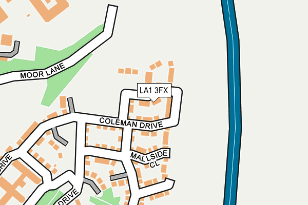
LA1 3FX is located in the Bulk electoral ward, within the local authority district of Lancaster and the English Parliamentary constituency of Lancaster and Fleetwood. The Sub Integrated Care Board (ICB) Location is NHS Lancashire and South Cumbria ICB - 01K and the police force is Lancashire. This postcode has been in use since March 2017.


GetTheData
Source: OS OpenMap – Local (Ordnance Survey)
Source: OS VectorMap District (Ordnance Survey)
Licence: Open Government Licence (requires attribution)
| Easting | 349861 |
| Northing | 462000 |
| Latitude | 54.051518 |
| Longitude | -2.767321 |
GetTheData
Source: Open Postcode Geo
Licence: Open Government Licence
| Country | England |
| Postcode District | LA1 |
➜ See where LA1 is on a map ➜ Where is Lancaster? | |
GetTheData
Source: Land Registry Price Paid Data
Licence: Open Government Licence
| Ward | Bulk |
| Constituency | Lancaster And Fleetwood |
GetTheData
Source: ONS Postcode Database
Licence: Open Government Licence
2023 7 JUL £420,000 |
2021 7 DEC £425,000 |
7, WOODLANDS CLOSE, LANCASTER, LA1 3FX 2018 28 JUN £409,995 |
35, WOODLANDS CLOSE, LANCASTER, LA1 3FX 2018 4 MAY £329,995 |
5, WOODLANDS CLOSE, LANCASTER, LA1 3FX 2018 29 MAR £367,995 |
8, WOODLANDS CLOSE, LANCASTER, LA1 3FX 2018 29 MAR £284,995 |
1, WOODLANDS CLOSE, LANCASTER, LA1 3FX 2018 2 MAR £364,995 |
3, WOODLANDS CLOSE, LANCASTER, LA1 3FX 2018 22 FEB £409,995 |
2018 26 JAN £364,995 |
11, WOODLANDS CLOSE, LANCASTER, LA1 3FX 2017 15 DEC £304,995 |
GetTheData
Source: HM Land Registry Price Paid Data
Licence: Contains HM Land Registry data © Crown copyright and database right 2024. This data is licensed under the Open Government Licence v3.0.
| Lancaster Farms Prison (Far Moor Lane) | Standen Gate | 373m |
| Ridge Lea Hospital (Stone Row Head) | Standen Gate | 471m |
| Ridge Lea Hospital (Stone Row Head) | Standen Gate | 486m |
| Moor Hospital (Quernmore Road) | Standen Gate | 566m |
| Moor Hospital Gates (Quernmore Road) | Standen Gate | 573m |
| Lancaster Station | 2.6km |
| Bare Lane Station | 5.1km |
GetTheData
Source: NaPTAN
Licence: Open Government Licence
| Percentage of properties with Next Generation Access | 100.0% |
| Percentage of properties with Superfast Broadband | 96.3% |
| Percentage of properties with Ultrafast Broadband | 0.0% |
| Percentage of properties with Full Fibre Broadband | 0.0% |
Superfast Broadband is between 30Mbps and 300Mbps
Ultrafast Broadband is > 300Mbps
| Median download speed | 37.8Mbps |
| Average download speed | 33.2Mbps |
| Maximum download speed | 50.60Mbps |
| Median upload speed | 7.1Mbps |
| Average upload speed | 6.8Mbps |
| Maximum upload speed | 10.00Mbps |
| Percentage of properties unable to receive 2Mbps | 0.0% |
| Percentage of properties unable to receive 5Mbps | 0.0% |
| Percentage of properties unable to receive 10Mbps | 0.0% |
| Percentage of properties unable to receive 30Mbps | 3.7% |
GetTheData
Source: Ofcom
Licence: Ofcom Terms of Use (requires attribution)
GetTheData
Source: ONS Postcode Database
Licence: Open Government Licence


➜ Get more ratings from the Food Standards Agency
GetTheData
Source: Food Standards Agency
Licence: FSA terms & conditions
| Last Collection | |||
|---|---|---|---|
| Location | Mon-Fri | Sat | Distance |
| Quernmore Road | 16:00 | 12:15 | 575m |
| 30 Windermere Road | 16:00 | 12:00 | 1,337m |
| Ridge Post Office | 16:00 | 12:00 | 1,377m |
GetTheData
Source: Dracos
Licence: Creative Commons Attribution-ShareAlike
The below table lists the International Territorial Level (ITL) codes (formerly Nomenclature of Territorial Units for Statistics (NUTS) codes) and Local Administrative Units (LAU) codes for LA1 3FX:
| ITL 1 Code | Name |
|---|---|
| TLD | North West (England) |
| ITL 2 Code | Name |
| TLD4 | Lancashire |
| ITL 3 Code | Name |
| TLD44 | Lancaster and Wyre |
| LAU 1 Code | Name |
| E07000121 | Lancaster |
GetTheData
Source: ONS Postcode Directory
Licence: Open Government Licence
The below table lists the Census Output Area (OA), Lower Layer Super Output Area (LSOA), and Middle Layer Super Output Area (MSOA) for LA1 3FX:
| Code | Name | |
|---|---|---|
| OA | E00127356 | |
| LSOA | E01025095 | Lancaster 013C |
| MSOA | E02005233 | Lancaster 013 |
GetTheData
Source: ONS Postcode Directory
Licence: Open Government Licence
| LA1 3FQ | Coleman Drive | 141m |
| LA1 3FZ | Mallside Close | 154m |
| LA1 3FS | Dutton Drive | 204m |
| LA1 3FT | Dutton Drive | 204m |
| LA1 3SA | Campbell Drive | 216m |
| LA1 3FY | Kershaw Drive | 390m |
| LA1 3SY | Kershaw Drive | 439m |
| LA1 3TG | Kershaw Drive | 490m |
| LA1 3SS | Oakland Close | 583m |
| LA1 3JW | Daisy Bank | 589m |
GetTheData
Source: Open Postcode Geo; Land Registry Price Paid Data
Licence: Open Government Licence