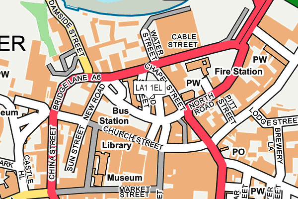
LA1 1EL is located in the Castle electoral ward, within the local authority district of Lancaster and the English Parliamentary constituency of Lancaster and Fleetwood. The Sub Integrated Care Board (ICB) Location is NHS Lancashire and South Cumbria ICB - 01K and the police force is Lancashire. This postcode has been in use since September 2021.


GetTheData
Source: OS OpenMap – Local (Ordnance Survey)
Source: OS VectorMap District (Ordnance Survey)
Licence: Open Government Licence (requires attribution)
| Easting | 347708 |
| Northing | 461888 |
| Latitude | 54.050297 |
| Longitude | -2.800183 |
GetTheData
Source: Open Postcode Geo
Licence: Open Government Licence
| Country | England |
| Postcode District | LA1 |
➜ See where LA1 is on a map ➜ Where is Lancaster? | |
GetTheData
Source: Land Registry Price Paid Data
Licence: Open Government Licence
| Ward | Castle |
| Constituency | Lancaster And Fleetwood |
GetTheData
Source: ONS Postcode Database
Licence: Open Government Licence
1, DYE HOUSE LANE, LANCASTER, LA1 1EL 2003 28 MAR £350,000 |
GetTheData
Source: HM Land Registry Price Paid Data
Licence: Contains HM Land Registry data © Crown copyright and database right 2024. This data is licensed under the Open Government Licence v3.0.
| Chapel Street | Lancaster City Centre | 55m |
| Waring And Gillow (North Road) | Lancaster City Centre | 210m |
| China Street | Lancaster City Centre | 233m |
| Sainsbury's Layby (Parliament Street) | Lancaster City Centre | 247m |
| Dalton Square | Lancaster City Centre | 287m |
| Lancaster Station | 0.5km |
| Bare Lane Station | 3.5km |
| Morecambe Station | 5km |
GetTheData
Source: NaPTAN
Licence: Open Government Licence
GetTheData
Source: ONS Postcode Database
Licence: Open Government Licence


➜ Get more ratings from the Food Standards Agency
GetTheData
Source: Food Standards Agency
Licence: FSA terms & conditions
| Last Collection | |||
|---|---|---|---|
| Location | Mon-Fri | Sat | Distance |
| Church Street | 17:30 | 12:00 | 133m |
| Stonewell Post Office | 17:30 | 12:00 | 173m |
| New Street | 17:30 | 12:00 | 195m |
GetTheData
Source: Dracos
Licence: Creative Commons Attribution-ShareAlike
The below table lists the International Territorial Level (ITL) codes (formerly Nomenclature of Territorial Units for Statistics (NUTS) codes) and Local Administrative Units (LAU) codes for LA1 1EL:
| ITL 1 Code | Name |
|---|---|
| TLD | North West (England) |
| ITL 2 Code | Name |
| TLD4 | Lancashire |
| ITL 3 Code | Name |
| TLD44 | Lancaster and Wyre |
| LAU 1 Code | Name |
| E07000121 | Lancaster |
GetTheData
Source: ONS Postcode Directory
Licence: Open Government Licence
The below table lists the Census Output Area (OA), Lower Layer Super Output Area (LSOA), and Middle Layer Super Output Area (MSOA) for LA1 1EL:
| Code | Name | |
|---|---|---|
| OA | E00127355 | |
| LSOA | E01025093 | Lancaster 014A |
| MSOA | E02005234 | Lancaster 014 |
GetTheData
Source: ONS Postcode Directory
Licence: Open Government Licence
| LA1 1NZ | Chapel Street | 37m |
| LA1 1PD | Damside Street | 46m |
| LA1 1LT | North Road | 59m |
| LA1 1HD | Cable Street | 86m |
| LA1 1LP | Church Street | 93m |
| LA1 1NP | Church Street | 101m |
| LA1 1NR | Rosemary Lane | 104m |
| LA1 1HF | Water Street | 112m |
| LA1 1HJ | St Johns Mews | 124m |
| LA1 1LZ | Cheapside | 127m |
GetTheData
Source: Open Postcode Geo; Land Registry Price Paid Data
Licence: Open Government Licence