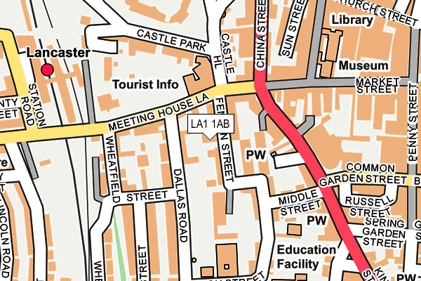
LA1 1AB lies on Fenton Street in Lancaster. LA1 1AB is located in the Castle electoral ward, within the local authority district of Lancaster and the English Parliamentary constituency of Lancaster and Fleetwood. The Sub Integrated Care Board (ICB) Location is NHS Lancashire and South Cumbria ICB - 01K and the police force is Lancashire. This postcode has been in use since January 1980.


GetTheData
Source: OS OpenMap – Local (Ordnance Survey)
Source: OS VectorMap District (Ordnance Survey)
Licence: Open Government Licence (requires attribution)
| Easting | 347440 |
| Northing | 461630 |
| Latitude | 54.047951 |
| Longitude | -2.804231 |
GetTheData
Source: Open Postcode Geo
Licence: Open Government Licence
| Street | Fenton Street |
| Town/City | Lancaster |
| Country | England |
| Postcode District | LA1 |
➜ See where LA1 is on a map ➜ Where is Lancaster? | |
GetTheData
Source: Land Registry Price Paid Data
Licence: Open Government Licence
Elevation or altitude of LA1 1AB as distance above sea level:
| Metres | Feet | |
|---|---|---|
| Elevation | 20m | 66ft |
Elevation is measured from the approximate centre of the postcode, to the nearest point on an OS contour line from OS Terrain 50, which has contour spacing of ten vertical metres.
➜ How high above sea level am I? Find the elevation of your current position using your device's GPS.
GetTheData
Source: Open Postcode Elevation
Licence: Open Government Licence
| Ward | Castle |
| Constituency | Lancaster And Fleetwood |
GetTheData
Source: ONS Postcode Database
Licence: Open Government Licence
| Fenton Street (Meeting House Lane) | Lancaster City Centre | 61m |
| Post Office (Meeting House Lane) | Lancaster City Centre | 68m |
| China Street | Lancaster City Centre | 161m |
| Railway Station (Meeting House Lane) | Lancaster City Centre | 172m |
| Common Garden Street | Lancaster City Centre | 203m |
| Lancaster Station | 0.2km |
| Bare Lane Station | 3.6km |
| Morecambe Station | 4.9km |
GetTheData
Source: NaPTAN
Licence: Open Government Licence
Estimated total energy consumption in LA1 1AB by fuel type, 2015.
| Consumption (kWh) | 60,945 |
|---|---|
| Meter count | 8 |
| Mean (kWh/meter) | 7,618 |
| Median (kWh/meter) | 7,435 |
| Consumption (kWh) | 18,422 |
|---|---|
| Meter count | 7 |
| Mean (kWh/meter) | 2,632 |
| Median (kWh/meter) | 2,253 |
GetTheData
Source: Postcode level gas estimates: 2015 (experimental)
Source: Postcode level electricity estimates: 2015 (experimental)
Licence: Open Government Licence
GetTheData
Source: ONS Postcode Database
Licence: Open Government Licence


➜ Get more ratings from the Food Standards Agency
GetTheData
Source: Food Standards Agency
Licence: FSA terms & conditions
| Last Collection | |||
|---|---|---|---|
| Location | Mon-Fri | Sat | Distance |
| Lancaster Post Office | 18:45 | 13:00 | 41m |
| Lancaster Post Office | 18:45 | 13:00 | 49m |
| New Street | 17:30 | 12:00 | 179m |
GetTheData
Source: Dracos
Licence: Creative Commons Attribution-ShareAlike
The below table lists the International Territorial Level (ITL) codes (formerly Nomenclature of Territorial Units for Statistics (NUTS) codes) and Local Administrative Units (LAU) codes for LA1 1AB:
| ITL 1 Code | Name |
|---|---|
| TLD | North West (England) |
| ITL 2 Code | Name |
| TLD4 | Lancashire |
| ITL 3 Code | Name |
| TLD44 | Lancaster and Wyre |
| LAU 1 Code | Name |
| E07000121 | Lancaster |
GetTheData
Source: ONS Postcode Directory
Licence: Open Government Licence
The below table lists the Census Output Area (OA), Lower Layer Super Output Area (LSOA), and Middle Layer Super Output Area (MSOA) for LA1 1AB:
| Code | Name | |
|---|---|---|
| OA | E00127404 | |
| LSOA | E01033071 | Lancaster 014E |
| MSOA | E02005234 | Lancaster 014 |
GetTheData
Source: ONS Postcode Directory
Licence: Open Government Licence
| LA1 1TN | Dallas Road | 43m |
| LA1 1TE | Fenton Street | 55m |
| LA1 1TJ | Meeting House Lane | 86m |
| LA1 1HP | Market Street | 103m |
| LA1 1JN | King Street | 109m |
| LA1 1AE | Harrier Court | 110m |
| LA1 1BE | Wheatfield Court | 129m |
| LA1 1UN | St James Court | 131m |
| LA1 1JY | King Street | 137m |
| LA1 1HS | Market Street | 138m |
GetTheData
Source: Open Postcode Geo; Land Registry Price Paid Data
Licence: Open Government Licence