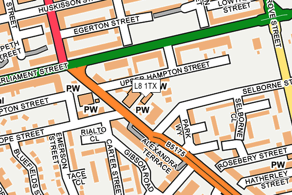
L8 1TX is located in the Princes Park electoral ward, within the metropolitan district of Liverpool and the English Parliamentary constituency of Liverpool, Riverside. The Sub Integrated Care Board (ICB) Location is NHS Cheshire and Merseyside ICB - 99A and the police force is Merseyside. This postcode has been in use since June 2008.


GetTheData
Source: OS OpenMap – Local (Ordnance Survey)
Source: OS VectorMap District (Ordnance Survey)
Licence: Open Government Licence (requires attribution)
| Easting | 335912 |
| Northing | 389172 |
| Latitude | 53.395471 |
| Longitude | -2.965243 |
GetTheData
Source: Open Postcode Geo
Licence: Open Government Licence
| Country | England |
| Postcode District | L8 |
➜ See where L8 is on a map ➜ Where is Liverpool? | |
GetTheData
Source: Land Registry Price Paid Data
Licence: Open Government Licence
Elevation or altitude of L8 1TX as distance above sea level:
| Metres | Feet | |
|---|---|---|
| Elevation | 40m | 131ft |
Elevation is measured from the approximate centre of the postcode, to the nearest point on an OS contour line from OS Terrain 50, which has contour spacing of ten vertical metres.
➜ How high above sea level am I? Find the elevation of your current position using your device's GPS.
GetTheData
Source: Open Postcode Elevation
Licence: Open Government Licence
| Ward | Princes Park |
| Constituency | Liverpool, Riverside |
GetTheData
Source: ONS Postcode Database
Licence: Open Government Licence
| Upper Parliament Street (Princes Road) | Toxteth | 77m |
| Princes Road (Upper Parliament Street) | Toxteth | 99m |
| Berkley Street (Upper Stanhope Street) | Toxteth | 112m |
| Carter Street (Upper Stanhope Street) | Windsor | 129m |
| Grove Street (Upper Parliament Street) | Toxteth | 205m |
| Liverpool Central Station | 1.4km |
| Edge Hill Station | 1.5km |
| Brunswick Station | 1.5km |
GetTheData
Source: NaPTAN
Licence: Open Government Licence
GetTheData
Source: ONS Postcode Database
Licence: Open Government Licence


➜ Get more ratings from the Food Standards Agency
GetTheData
Source: Food Standards Agency
Licence: FSA terms & conditions
| Last Collection | |||
|---|---|---|---|
| Location | Mon-Fri | Sat | Distance |
| Sandon Street | 17:30 | 12:00 | 165m |
| Upper Parliament Street | 17:30 | 12:00 | 264m |
| Bedford Street | 17:30 | 12:00 | 313m |
GetTheData
Source: Dracos
Licence: Creative Commons Attribution-ShareAlike
The below table lists the International Territorial Level (ITL) codes (formerly Nomenclature of Territorial Units for Statistics (NUTS) codes) and Local Administrative Units (LAU) codes for L8 1TX:
| ITL 1 Code | Name |
|---|---|
| TLD | North West (England) |
| ITL 2 Code | Name |
| TLD7 | Merseyside |
| ITL 3 Code | Name |
| TLD72 | Liverpool |
| LAU 1 Code | Name |
| E08000012 | Liverpool |
GetTheData
Source: ONS Postcode Directory
Licence: Open Government Licence
The below table lists the Census Output Area (OA), Lower Layer Super Output Area (LSOA), and Middle Layer Super Output Area (MSOA) for L8 1TX:
| Code | Name | |
|---|---|---|
| OA | E00033846 | |
| LSOA | E01006673 | Liverpool 037D |
| MSOA | E02001383 | Liverpool 037 |
GetTheData
Source: ONS Postcode Directory
Licence: Open Government Licence
| L8 1TG | Princes Road | 31m |
| L8 1TN | Markden Mews | 60m |
| L8 1TL | Upper Hampton Street | 66m |
| L8 7LG | Upper Parliament Street | 83m |
| L8 7LQ | Upper Parliament Street | 89m |
| L8 1UN | Upper Stanhope Street | 110m |
| L8 1TS | Parkway | 112m |
| L8 1TH | Princes Road | 117m |
| L8 1XB | Berkley Street | 178m |
| L8 7LY | Egerton Street | 179m |
GetTheData
Source: Open Postcode Geo; Land Registry Price Paid Data
Licence: Open Government Licence