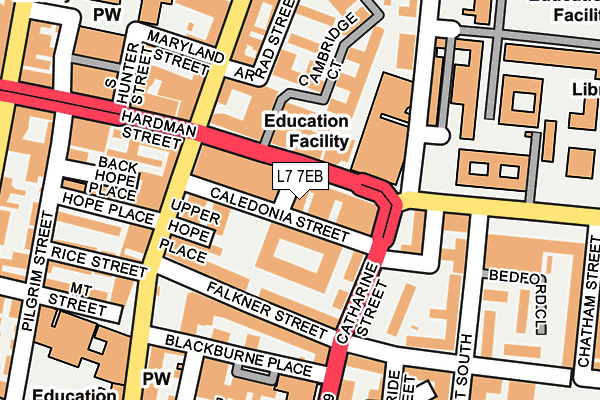
L7 7EB lies on Sugnall Street in Liverpool. L7 7EB is located in the Canning electoral ward, within the metropolitan district of Liverpool and the English Parliamentary constituency of Liverpool, Riverside. The Sub Integrated Care Board (ICB) Location is NHS Cheshire and Merseyside ICB - 99A and the police force is Merseyside. This postcode has been in use since January 1980.


GetTheData
Source: OS OpenMap – Local (Ordnance Survey)
Source: OS VectorMap District (Ordnance Survey)
Licence: Open Government Licence (requires attribution)
| Easting | 335649 |
| Northing | 389747 |
| Latitude | 53.400624 |
| Longitude | -2.969315 |
GetTheData
Source: Open Postcode Geo
Licence: Open Government Licence
| Street | Sugnall Street |
| Town/City | Liverpool |
| Country | England |
| Postcode District | L7 |
➜ See where L7 is on a map ➜ Where is Liverpool? | |
GetTheData
Source: Land Registry Price Paid Data
Licence: Open Government Licence
Elevation or altitude of L7 7EB as distance above sea level:
| Metres | Feet | |
|---|---|---|
| Elevation | 40m | 131ft |
Elevation is measured from the approximate centre of the postcode, to the nearest point on an OS contour line from OS Terrain 50, which has contour spacing of ten vertical metres.
➜ How high above sea level am I? Find the elevation of your current position using your device's GPS.
GetTheData
Source: Open Postcode Elevation
Licence: Open Government Licence
| Ward | Canning |
| Constituency | Liverpool, Riverside |
GetTheData
Source: ONS Postcode Database
Licence: Open Government Licence
8, SUGNALL STREET, LIVERPOOL, L7 7EB 2005 23 MAY £365,000 |
8, SUGNALL STREET, LIVERPOOL, L7 7EB 2004 22 DEC £330,000 |
GetTheData
Source: HM Land Registry Price Paid Data
Licence: Contains HM Land Registry data © Crown copyright and database right 2025. This data is licensed under the Open Government Licence v3.0.
| Hope Street (Myrtle Street) | Liverpool | 82m |
| Mulberry Street (Myrtle Street) | Liverpool | 97m |
| Arrad Street | Liverpool | 137m |
| Blackburne Place (Catharine Street) | Liverpool | 181m |
| Back Canning Street (Catharine Street) | Liverpool | 186m |
| Liverpool Central Station | 0.8km |
| Liverpool Lime Street Station | 0.9km |
| Liverpool Lime Street Low Level Station | 1km |
GetTheData
Source: NaPTAN
Licence: Open Government Licence
GetTheData
Source: ONS Postcode Database
Licence: Open Government Licence


➜ Get more ratings from the Food Standards Agency
GetTheData
Source: Food Standards Agency
Licence: FSA terms & conditions
| Last Collection | |||
|---|---|---|---|
| Location | Mon-Fri | Sat | Distance |
| Hardman Street | 18:00 | 12:00 | 122m |
| Catherine Street | 17:30 | 12:00 | 127m |
| Myrtle Street | 17:30 | 12:00 | 190m |
GetTheData
Source: Dracos
Licence: Creative Commons Attribution-ShareAlike
The below table lists the International Territorial Level (ITL) codes (formerly Nomenclature of Territorial Units for Statistics (NUTS) codes) and Local Administrative Units (LAU) codes for L7 7EB:
| ITL 1 Code | Name |
|---|---|
| TLD | North West (England) |
| ITL 2 Code | Name |
| TLD7 | Merseyside |
| ITL 3 Code | Name |
| TLD72 | Liverpool |
| LAU 1 Code | Name |
| E08000012 | Liverpool |
GetTheData
Source: ONS Postcode Directory
Licence: Open Government Licence
The below table lists the Census Output Area (OA), Lower Layer Super Output Area (LSOA), and Middle Layer Super Output Area (MSOA) for L7 7EB:
| Code | Name | |
|---|---|---|
| OA | E00176694 | |
| LSOA | E01006514 | Liverpool 037A |
| MSOA | E02001383 | Liverpool 037 |
GetTheData
Source: ONS Postcode Directory
Licence: Open Government Licence
| L8 7PU | Falkner Street | 58m |
| L8 7PZ | Falkner Street | 93m |
| L7 7DN | Myrtle Street | 98m |
| L8 7PE | Blackburne Place | 110m |
| L7 7DL | Stowell Street | 116m |
| L8 7PJ | Blackburne Terrace | 151m |
| L1 9BZ | Hope Street | 157m |
| L1 9BG | Hope Place | 169m |
| L7 7DP | Myrtle Street | 174m |
| L1 9BX | Hope Street | 176m |
GetTheData
Source: Open Postcode Geo; Land Registry Price Paid Data
Licence: Open Government Licence