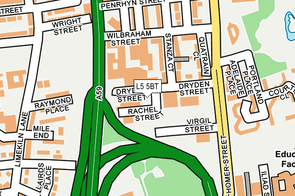
L5 5BT is located in the Everton West electoral ward, within the metropolitan district of Liverpool and the English Parliamentary constituency of Liverpool, Walton. The Sub Integrated Care Board (ICB) Location is NHS Cheshire and Merseyside ICB - 99A and the police force is Merseyside. This postcode has been in use since January 1980.


GetTheData
Source: OS OpenMap – Local (Ordnance Survey)
Source: OS VectorMap District (Ordnance Survey)
Licence: Open Government Licence (requires attribution)
| Easting | 334948 |
| Northing | 391906 |
| Latitude | 53.419924 |
| Longitude | -2.980303 |
GetTheData
Source: Open Postcode Geo
Licence: Open Government Licence
| Country | England |
| Postcode District | L5 |
➜ See where L5 is on a map ➜ Where is Liverpool? | |
GetTheData
Source: Land Registry Price Paid Data
Licence: Open Government Licence
Elevation or altitude of L5 5BT as distance above sea level:
| Metres | Feet | |
|---|---|---|
| Elevation | 30m | 98ft |
Elevation is measured from the approximate centre of the postcode, to the nearest point on an OS contour line from OS Terrain 50, which has contour spacing of ten vertical metres.
➜ How high above sea level am I? Find the elevation of your current position using your device's GPS.
GetTheData
Source: Open Postcode Elevation
Licence: Open Government Licence
| Ward | Everton West |
| Constituency | Liverpool, Walton |
GetTheData
Source: ONS Postcode Database
Licence: Open Government Licence
| Virgil Street (Great Homer Street) | Kirkdale | 153m |
| Roscommon Street (Great Homer Street) | Everton | 184m |
| Wilbraham Street (Great Homer Street) | Everton | 210m |
| Raymond Place (Limekiln Lane) | Vauxhall | 249m |
| Penrhyn Street (Great Homer Street) | Everton | 250m |
| Liverpool Lime Street Low Level Station | 1.3km |
| Sandhills Station | 1.3km |
| Moorfields Station | 1.4km |
GetTheData
Source: NaPTAN
Licence: Open Government Licence
GetTheData
Source: ONS Postcode Database
Licence: Open Government Licence


➜ Get more ratings from the Food Standards Agency
GetTheData
Source: Food Standards Agency
Licence: FSA terms & conditions
| Last Collection | |||
|---|---|---|---|
| Location | Mon-Fri | Sat | Distance |
| Heyworth Street | 16:30 | 12:00 | 790m |
| Breck Road/ Everton Road | 17:30 | 12:00 | 931m |
| St.martins Road | 17:30 | 12:00 | 1,029m |
GetTheData
Source: Dracos
Licence: Creative Commons Attribution-ShareAlike
The below table lists the International Territorial Level (ITL) codes (formerly Nomenclature of Territorial Units for Statistics (NUTS) codes) and Local Administrative Units (LAU) codes for L5 5BT:
| ITL 1 Code | Name |
|---|---|
| TLD | North West (England) |
| ITL 2 Code | Name |
| TLD7 | Merseyside |
| ITL 3 Code | Name |
| TLD72 | Liverpool |
| LAU 1 Code | Name |
| E08000012 | Liverpool |
GetTheData
Source: ONS Postcode Directory
Licence: Open Government Licence
The below table lists the Census Output Area (OA), Lower Layer Super Output Area (LSOA), and Middle Layer Super Output Area (MSOA) for L5 5BT:
| Code | Name | |
|---|---|---|
| OA | E00034360 | |
| LSOA | E01033764 | Liverpool 022E |
| MSOA | E02001368 | Liverpool 022 |
GetTheData
Source: ONS Postcode Directory
Licence: Open Government Licence
| L5 5BH | Stanza Court | 92m |
| L5 5BL | Wilbraham Street | 141m |
| L5 5BQ | Wilbraham Street | 164m |
| L5 3LF | Great Homer Street | 168m |
| L5 8XL | Raymond Place | 191m |
| L5 8XW | Tenterden Street | 208m |
| L5 5BP | Penrhyn Street | 218m |
| L5 8XJ | Mile End | 227m |
| L5 8SB | Wright Street | 236m |
| L5 3PJ | Portland Place | 240m |
GetTheData
Source: Open Postcode Geo; Land Registry Price Paid Data
Licence: Open Government Licence