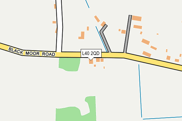
L40 2QD lies on Black Moor Road in Mawdesley, Ormskirk. L40 2QD is located in the Croston, Mawdesley & Euxton South electoral ward, within the local authority district of Chorley and the English Parliamentary constituency of South Ribble. The Sub Integrated Care Board (ICB) Location is NHS Lancashire and South Cumbria ICB - 00X and the police force is Lancashire. This postcode has been in use since January 1980.


GetTheData
Source: OS OpenMap – Local (Ordnance Survey)
Source: OS VectorMap District (Ordnance Survey)
Licence: Open Government Licence (requires attribution)
| Easting | 347881 |
| Northing | 414849 |
| Latitude | 53.627564 |
| Longitude | -2.789549 |
GetTheData
Source: Open Postcode Geo
Licence: Open Government Licence
| Street | Black Moor Road |
| Locality | Mawdesley |
| Town/City | Ormskirk |
| Country | England |
| Postcode District | L40 |
➜ See where L40 is on a map | |
GetTheData
Source: Land Registry Price Paid Data
Licence: Open Government Licence
Elevation or altitude of L40 2QD as distance above sea level:
| Metres | Feet | |
|---|---|---|
| Elevation | 10m | 33ft |
Elevation is measured from the approximate centre of the postcode, to the nearest point on an OS contour line from OS Terrain 50, which has contour spacing of ten vertical metres.
➜ How high above sea level am I? Find the elevation of your current position using your device's GPS.
GetTheData
Source: Open Postcode Elevation
Licence: Open Government Licence
| Ward | Croston, Mawdesley & Euxton South |
| Constituency | South Ribble |
GetTheData
Source: ONS Postcode Database
Licence: Open Government Licence
| Blackmoor Road | Mawdesley | 496m |
| Sandy Lane | Mawdesley | 687m |
| Daub Lane (Rufford Road) | Bispham Green | 942m |
| Smithy Lane | Mawdesley | 1,000m |
| Four Lane Ends (High Street) | Mawdesley | 1,208m |
| Rufford Station | 1.4km |
| Hoscar Station | 3.5km |
| Burscough Bridge Station | 4.2km |
GetTheData
Source: NaPTAN
Licence: Open Government Licence
| Percentage of properties with Next Generation Access | 100.0% |
| Percentage of properties with Superfast Broadband | 100.0% |
| Percentage of properties with Ultrafast Broadband | 100.0% |
| Percentage of properties with Full Fibre Broadband | 100.0% |
Superfast Broadband is between 30Mbps and 300Mbps
Ultrafast Broadband is > 300Mbps
| Percentage of properties unable to receive 2Mbps | 0.0% |
| Percentage of properties unable to receive 5Mbps | 0.0% |
| Percentage of properties unable to receive 10Mbps | 0.0% |
| Percentage of properties unable to receive 30Mbps | 0.0% |
GetTheData
Source: Ofcom
Licence: Ofcom Terms of Use (requires attribution)
Estimated total energy consumption in L40 2QD by fuel type, 2015.
| Consumption (kWh) | 176,663 |
|---|---|
| Meter count | 7 |
| Mean (kWh/meter) | 25,238 |
| Median (kWh/meter) | 19,468 |
| Consumption (kWh) | 78,285 |
|---|---|
| Meter count | 11 |
| Mean (kWh/meter) | 7,117 |
| Median (kWh/meter) | 2,844 |
GetTheData
Source: Postcode level gas estimates: 2015 (experimental)
Source: Postcode level electricity estimates: 2015 (experimental)
Licence: Open Government Licence
GetTheData
Source: ONS Postcode Database
Licence: Open Government Licence


➜ Get more ratings from the Food Standards Agency
GetTheData
Source: Food Standards Agency
Licence: FSA terms & conditions
| Last Collection | |||
|---|---|---|---|
| Location | Mon-Fri | Sat | Distance |
| Bispham Grammar School | 16:00 | 08:00 | 2,643m |
| Hilldale | 17:05 | 11:00 | 3,142m |
| Rufford Post Office | 16:45 | 11:30 | 3,262m |
GetTheData
Source: Dracos
Licence: Creative Commons Attribution-ShareAlike
The below table lists the International Territorial Level (ITL) codes (formerly Nomenclature of Territorial Units for Statistics (NUTS) codes) and Local Administrative Units (LAU) codes for L40 2QD:
| ITL 1 Code | Name |
|---|---|
| TLD | North West (England) |
| ITL 2 Code | Name |
| TLD4 | Lancashire |
| ITL 3 Code | Name |
| TLD47 | Chorley and West Lancashire |
| LAU 1 Code | Name |
| E07000118 | Chorley |
GetTheData
Source: ONS Postcode Directory
Licence: Open Government Licence
The below table lists the Census Output Area (OA), Lower Layer Super Output Area (LSOA), and Middle Layer Super Output Area (MSOA) for L40 2QD:
| Code | Name | |
|---|---|---|
| OA | E00126714 | |
| LSOA | E01024964 | Chorley 007A |
| MSOA | E02005195 | Chorley 007 |
GetTheData
Source: ONS Postcode Directory
Licence: Open Government Licence
| L40 2PA | Black Moor Lane | 216m |
| L40 2QE | Black Moor Road | 314m |
| L40 2QB | Sandy Lane | 462m |
| L40 2QF | Black Moor Road | 485m |
| L40 3SA | Rufford Road | 695m |
| L40 2QA | Meadow Lane | 946m |
| L40 3TQ | Daub Lane | 988m |
| L40 2QH | Gales Lane | 1031m |
| L40 2QQ | Smithy Lane | 1058m |
| L40 3TR | Jay Bank | 1065m |
GetTheData
Source: Open Postcode Geo; Land Registry Price Paid Data
Licence: Open Government Licence