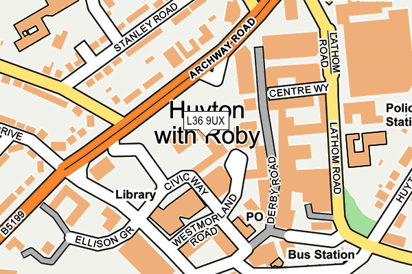
L36 9UX is located in the Roby electoral ward, within the metropolitan district of Knowsley and the English Parliamentary constituency of Knowsley. The Sub Integrated Care Board (ICB) Location is NHS Cheshire and Merseyside ICB - 01J and the police force is Merseyside. This postcode has been in use since January 1980.


GetTheData
Source: OS OpenMap – Local (Ordnance Survey)
Source: OS VectorMap District (Ordnance Survey)
Licence: Open Government Licence (requires attribution)
| Easting | 344211 |
| Northing | 390875 |
| Latitude | 53.411721 |
| Longitude | -2.840757 |
GetTheData
Source: Open Postcode Geo
Licence: Open Government Licence
| Country | England |
| Postcode District | L36 |
➜ See where L36 is on a map ➜ Where is Huyton with Roby? | |
GetTheData
Source: Land Registry Price Paid Data
Licence: Open Government Licence
Elevation or altitude of L36 9UX as distance above sea level:
| Metres | Feet | |
|---|---|---|
| Elevation | 40m | 131ft |
Elevation is measured from the approximate centre of the postcode, to the nearest point on an OS contour line from OS Terrain 50, which has contour spacing of ten vertical metres.
➜ How high above sea level am I? Find the elevation of your current position using your device's GPS.
GetTheData
Source: Open Postcode Elevation
Licence: Open Government Licence
| Ward | Roby |
| Constituency | Knowsley |
GetTheData
Source: ONS Postcode Database
Licence: Open Government Licence
| Huyton Town Centre (Archway Road) | Knowsley | 73m |
| Lyndhurst Way (Archway Road) | Knowsley | 76m |
| Lyndhurst Way (Archway Road) | Knowsley | 83m |
| Police Station (Lathom Road) | Huyton | 181m |
| Westmorland Road (Poplar Bank) | Knowsley | 181m |
| Huyton Station | 0.3km |
| Roby Station | 1km |
| Whiston Station | 3km |
GetTheData
Source: NaPTAN
Licence: Open Government Licence
GetTheData
Source: ONS Postcode Database
Licence: Open Government Licence


➜ Get more ratings from the Food Standards Agency
GetTheData
Source: Food Standards Agency
Licence: FSA terms & conditions
| Last Collection | |||
|---|---|---|---|
| Location | Mon-Fri | Sat | Distance |
| Huyton Post Office | 17:45 | 12:00 | 161m |
| Glade Road | 17:00 | 12:00 | 947m |
| The Boundary | 17:30 | 12:00 | 1,445m |
GetTheData
Source: Dracos
Licence: Creative Commons Attribution-ShareAlike
The below table lists the International Territorial Level (ITL) codes (formerly Nomenclature of Territorial Units for Statistics (NUTS) codes) and Local Administrative Units (LAU) codes for L36 9UX:
| ITL 1 Code | Name |
|---|---|
| TLD | North West (England) |
| ITL 2 Code | Name |
| TLD7 | Merseyside |
| ITL 3 Code | Name |
| TLD71 | East Merseyside |
| LAU 1 Code | Name |
| E08000011 | Knowsley |
GetTheData
Source: ONS Postcode Directory
Licence: Open Government Licence
The below table lists the Census Output Area (OA), Lower Layer Super Output Area (LSOA), and Middle Layer Super Output Area (MSOA) for L36 9UX:
| Code | Name | |
|---|---|---|
| OA | E00032816 | |
| LSOA | E01006474 | Knowsley 016C |
| MSOA | E02001342 | Knowsley 016 |
GetTheData
Source: ONS Postcode Directory
Licence: Open Government Licence
| L36 9XB | Archway Road | 115m |
| L36 9BB | Stanley Road | 130m |
| L36 9XW | Stanley Road | 165m |
| L36 9XD | Archway Road | 195m |
| L36 5YH | Huyton Hey Road | 209m |
| L36 9XL | Stanley Road | 210m |
| L36 9GE | Priory Court | 214m |
| L36 7TW | Blue Bell Lane | 218m |
| L36 9XN | Stanley Road | 219m |
| L36 9TF | Rupert Road | 233m |
GetTheData
Source: Open Postcode Geo; Land Registry Price Paid Data
Licence: Open Government Licence