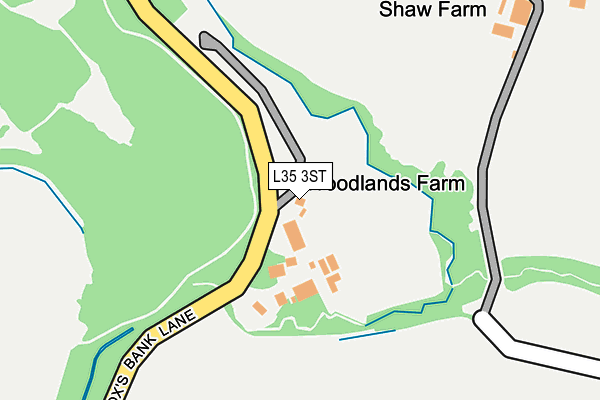
L35 3ST is located in the Whiston and Cronton electoral ward, within the metropolitan district of Knowsley and the English Parliamentary constituency of St Helens South and Whiston. The Sub Integrated Care Board (ICB) Location is NHS Cheshire and Merseyside ICB - 01J and the police force is Merseyside. This postcode has been in use since January 1980.


GetTheData
Source: OS OpenMap – Local (Ordnance Survey)
Source: OS VectorMap District (Ordnance Survey)
Licence: Open Government Licence (requires attribution)
| Easting | 347952 |
| Northing | 389177 |
| Latitude | 53.396858 |
| Longitude | -2.784203 |
GetTheData
Source: Open Postcode Geo
Licence: Open Government Licence
| Country | England |
| Postcode District | L35 |
➜ See where L35 is on a map | |
GetTheData
Source: Land Registry Price Paid Data
Licence: Open Government Licence
Elevation or altitude of L35 3ST as distance above sea level:
| Metres | Feet | |
|---|---|---|
| Elevation | 30m | 98ft |
Elevation is measured from the approximate centre of the postcode, to the nearest point on an OS contour line from OS Terrain 50, which has contour spacing of ten vertical metres.
➜ How high above sea level am I? Find the elevation of your current position using your device's GPS.
GetTheData
Source: Open Postcode Elevation
Licence: Open Government Licence
| Ward | Whiston And Cronton |
| Constituency | St Helens South And Whiston |
GetTheData
Source: ONS Postcode Database
Licence: Open Government Licence
| Cronton Road | Cronton | 391m |
| Cronton Road | Cronton | 398m |
| Foxs Bank Lane (Cronton Road) | Cronton | 433m |
| Prescot Road (Cronton Road) | Cronton | 448m |
| Tue Lane (Cronton Road) | Cronton | 639m |
| Whiston Station | 2.1km |
| Rainhill Station | 2.5km |
| Hough Green Station | 2.8km |
GetTheData
Source: NaPTAN
Licence: Open Government Licence
GetTheData
Source: ONS Postcode Database
Licence: Open Government Licence


➜ Get more ratings from the Food Standards Agency
GetTheData
Source: Food Standards Agency
Licence: FSA terms & conditions
| Last Collection | |||
|---|---|---|---|
| Location | Mon-Fri | Sat | Distance |
| Halsnead Avenue | 16:30 | 11:30 | 1,666m |
| Blackhorse Post Office | 18:00 | 12:00 | 2,230m |
| The Boundary | 17:30 | 12:00 | 2,850m |
GetTheData
Source: Dracos
Licence: Creative Commons Attribution-ShareAlike
The below table lists the International Territorial Level (ITL) codes (formerly Nomenclature of Territorial Units for Statistics (NUTS) codes) and Local Administrative Units (LAU) codes for L35 3ST:
| ITL 1 Code | Name |
|---|---|
| TLD | North West (England) |
| ITL 2 Code | Name |
| TLD7 | Merseyside |
| ITL 3 Code | Name |
| TLD71 | East Merseyside |
| LAU 1 Code | Name |
| E08000011 | Knowsley |
GetTheData
Source: ONS Postcode Directory
Licence: Open Government Licence
The below table lists the Census Output Area (OA), Lower Layer Super Output Area (LSOA), and Middle Layer Super Output Area (MSOA) for L35 3ST:
| Code | Name | |
|---|---|---|
| OA | E00032944 | |
| LSOA | E01006502 | Knowsley 017C |
| MSOA | E02001343 | Knowsley 017 |
GetTheData
Source: ONS Postcode Directory
Licence: Open Government Licence
| L35 1QU | Cronton Road | 473m |
| WA8 5PU | Penny Lane | 563m |
| L35 3SU | Halsnead Hall Villas | 582m |
| L35 1QR | Park Villas | 730m |
| WA8 5PX | Cronton Road | 763m |
| L35 3SS | Foxs Bank Lane | 1010m |
| L35 1QZ | Dacres Bridge Lane | 1146m |
| WA8 5PZ | Cronton Road | 1238m |
| L35 3QD | Lickers Lane | 1344m |
| WA8 5HL | Houghton Croft | 1374m |
GetTheData
Source: Open Postcode Geo; Land Registry Price Paid Data
Licence: Open Government Licence