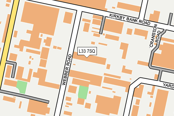
L33 7SQ lies on Webber Road in Knowsley Industrial Park, Liverpool. L33 7SQ is located in the Northwood electoral ward, within the metropolitan district of Knowsley and the English Parliamentary constituency of Knowsley. The Sub Integrated Care Board (ICB) Location is NHS Cheshire and Merseyside ICB - 01J and the police force is Merseyside. This postcode has been in use since May 2009.


GetTheData
Source: OS OpenMap – Local (Ordnance Survey)
Source: OS VectorMap District (Ordnance Survey)
Licence: Open Government Licence (requires attribution)
| Easting | 343068 |
| Northing | 398482 |
| Latitude | 53.479982 |
| Longitude | -2.859329 |
GetTheData
Source: Open Postcode Geo
Licence: Open Government Licence
| Street | Webber Road |
| Locality | Knowsley Industrial Park |
| Town/City | Liverpool |
| Country | England |
| Postcode District | L33 |
➜ See where L33 is on a map ➜ Where is Kirkby? | |
GetTheData
Source: Land Registry Price Paid Data
Licence: Open Government Licence
Elevation or altitude of L33 7SQ as distance above sea level:
| Metres | Feet | |
|---|---|---|
| Elevation | 40m | 131ft |
Elevation is measured from the approximate centre of the postcode, to the nearest point on an OS contour line from OS Terrain 50, which has contour spacing of ten vertical metres.
➜ How high above sea level am I? Find the elevation of your current position using your device's GPS.
GetTheData
Source: Open Postcode Elevation
Licence: Open Government Licence
| Ward | Northwood |
| Constituency | Knowsley |
GetTheData
Source: ONS Postcode Database
Licence: Open Government Licence
| Kirkby Bank Road (Webber Road) | Knowsley Industrial Park | 173m |
| Charleywood Road (Webber Road) | Knowsley Industrial Park | 178m |
| Lees Road (Charleywood Road) | Knowsley Industrial Park | 285m |
| Kirkby Bank Road (Birchill Road) | Knowsley Industrial Park | 288m |
| Yardley Road (Charleywood Road) | Knowsley Industrial Park | 325m |
| Kirkby Station | 3km |
| Maghull Station | 5.6km |
| Rainford Station | 6.2km |
GetTheData
Source: NaPTAN
Licence: Open Government Licence
| Median download speed | 72.2Mbps |
| Average download speed | 61.5Mbps |
| Maximum download speed | 80.00Mbps |
| Median upload speed | 17.4Mbps |
| Average upload speed | 15.1Mbps |
| Maximum upload speed | 20.00Mbps |
GetTheData
Source: Ofcom
Licence: Ofcom Terms of Use (requires attribution)
GetTheData
Source: ONS Postcode Database
Licence: Open Government Licence

➜ Get more ratings from the Food Standards Agency
GetTheData
Source: Food Standards Agency
Licence: FSA terms & conditions
| Last Collection | |||
|---|---|---|---|
| Location | Mon-Fri | Sat | Distance |
| Saxon Way/Washington Drive | 17:00 | 12:00 | 785m |
| Kirkby Post Office | 18:00 | 12:00 | 1,787m |
| Broad Lane/Medbourne Crescent | 17:00 | 12:00 | 2,117m |
GetTheData
Source: Dracos
Licence: Creative Commons Attribution-ShareAlike
The below table lists the International Territorial Level (ITL) codes (formerly Nomenclature of Territorial Units for Statistics (NUTS) codes) and Local Administrative Units (LAU) codes for L33 7SQ:
| ITL 1 Code | Name |
|---|---|
| TLD | North West (England) |
| ITL 2 Code | Name |
| TLD7 | Merseyside |
| ITL 3 Code | Name |
| TLD71 | East Merseyside |
| LAU 1 Code | Name |
| E08000011 | Knowsley |
GetTheData
Source: ONS Postcode Directory
Licence: Open Government Licence
The below table lists the Census Output Area (OA), Lower Layer Super Output Area (LSOA), and Middle Layer Super Output Area (MSOA) for L33 7SQ:
| Code | Name | |
|---|---|---|
| OA | E00032679 | |
| LSOA | E01006446 | Knowsley 005G |
| MSOA | E02001331 | Knowsley 005 |
GetTheData
Source: ONS Postcode Directory
Licence: Open Government Licence
| L33 7SW | Webber Road | 82m |
| L33 7SE | Lees Road | 270m |
| L33 7SY | Kirkby Bank Road | 281m |
| L33 7RW | Lees Road | 463m |
| L33 7BA | Deltic Way | 480m |
| L33 7XB | Arbour Lane | 486m |
| L33 7TJ | Newstet Road | 497m |
| L33 7XE | Arbour Court | 522m |
| L33 7ET | Arbour Lane | 742m |
| L33 5XE | Simonswood Lane | 770m |
GetTheData
Source: Open Postcode Geo; Land Registry Price Paid Data
Licence: Open Government Licence