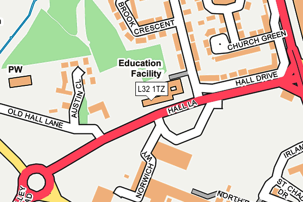
L32 1TZ is located in the Whitefield electoral ward, within the metropolitan district of Knowsley and the English Parliamentary constituency of Knowsley. The Sub Integrated Care Board (ICB) Location is NHS Cheshire and Merseyside ICB - 01J and the police force is Merseyside. This postcode has been in use since June 2002.


GetTheData
Source: OS OpenMap – Local (Ordnance Survey)
Source: OS VectorMap District (Ordnance Survey)
Licence: Open Government Licence (requires attribution)
| Easting | 341145 |
| Northing | 398980 |
| Latitude | 53.484246 |
| Longitude | -2.888394 |
GetTheData
Source: Open Postcode Geo
Licence: Open Government Licence
| Country | England |
| Postcode District | L32 |
➜ See where L32 is on a map ➜ Where is Kirkby? | |
GetTheData
Source: Land Registry Price Paid Data
Licence: Open Government Licence
Elevation or altitude of L32 1TZ as distance above sea level:
| Metres | Feet | |
|---|---|---|
| Elevation | 30m | 98ft |
Elevation is measured from the approximate centre of the postcode, to the nearest point on an OS contour line from OS Terrain 50, which has contour spacing of ten vertical metres.
➜ How high above sea level am I? Find the elevation of your current position using your device's GPS.
GetTheData
Source: Open Postcode Elevation
Licence: Open Government Licence
| Ward | Whitefield |
| Constituency | Knowsley |
GetTheData
Source: ONS Postcode Database
Licence: Open Government Licence
| Milbrook Drive (Hall Road) | Kirkby | 34m |
| Old Hall Lane (Hall Lane) | Kirkby | 103m |
| Old Hall Lane (Hall Lane) | Kirkby | 150m |
| County Road (Hall Lane) | Kirkby | 160m |
| County Road (Hall Lane) | Kirkby | 189m |
| Kirkby Station | 1km |
| Fazakerley Station | 3.6km |
| Maghull Station | 3.7km |
GetTheData
Source: NaPTAN
Licence: Open Government Licence
Estimated total energy consumption in L32 1TZ by fuel type, 2015.
| Consumption (kWh) | 27,235 |
|---|---|
| Meter count | 7 |
| Mean (kWh/meter) | 3,891 |
| Median (kWh/meter) | 3,776 |
GetTheData
Source: Postcode level gas estimates: 2015 (experimental)
Source: Postcode level electricity estimates: 2015 (experimental)
Licence: Open Government Licence
GetTheData
Source: ONS Postcode Database
Licence: Open Government Licence


➜ Get more ratings from the Food Standards Agency
GetTheData
Source: Food Standards Agency
Licence: FSA terms & conditions
| Last Collection | |||
|---|---|---|---|
| Location | Mon-Fri | Sat | Distance |
| Kirkby Post Office | 18:00 | 12:00 | 374m |
| Saxon Way/Washington Drive | 17:00 | 12:00 | 1,419m |
| Broad Lane/Medbourne Crescent | 17:00 | 12:00 | 1,726m |
GetTheData
Source: Dracos
Licence: Creative Commons Attribution-ShareAlike
The below table lists the International Territorial Level (ITL) codes (formerly Nomenclature of Territorial Units for Statistics (NUTS) codes) and Local Administrative Units (LAU) codes for L32 1TZ:
| ITL 1 Code | Name |
|---|---|
| TLD | North West (England) |
| ITL 2 Code | Name |
| TLD7 | Merseyside |
| ITL 3 Code | Name |
| TLD71 | East Merseyside |
| LAU 1 Code | Name |
| E08000011 | Knowsley |
GetTheData
Source: ONS Postcode Directory
Licence: Open Government Licence
The below table lists the Census Output Area (OA), Lower Layer Super Output Area (LSOA), and Middle Layer Super Output Area (MSOA) for L32 1TZ:
| Code | Name | |
|---|---|---|
| OA | E00032724 | |
| LSOA | E01006457 | Knowsley 002C |
| MSOA | E02001328 | Knowsley 002 |
GetTheData
Source: ONS Postcode Directory
Licence: Open Government Licence
| L32 1TE | Milbrook Drive | 83m |
| L32 1TD | Milbrook Walk | 132m |
| L32 1TB | Church Green | 135m |
| L32 1TA | Hall Drive | 139m |
| L32 1TJ | Milbrook Crescent | 170m |
| L32 1TG | Church Way | 170m |
| L32 5UP | Austin Close | 218m |
| L32 8UG | St Chads Parade | 227m |
| L32 1TF | Milbrook Drive | 243m |
| L32 1TQ | Church Way | 268m |
GetTheData
Source: Open Postcode Geo; Land Registry Price Paid Data
Licence: Open Government Licence