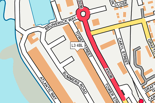
L3 4BL is located in the Festival Gardens electoral ward, within the metropolitan district of Liverpool and the English Parliamentary constituency of Liverpool, Riverside. The Sub Integrated Care Board (ICB) Location is NHS Cheshire and Merseyside ICB - 99A and the police force is Merseyside. This postcode has been in use since January 1993.


GetTheData
Source: OS OpenMap – Local (Ordnance Survey)
Source: OS VectorMap District (Ordnance Survey)
Licence: Open Government Licence (requires attribution)
| Easting | 334929 |
| Northing | 388015 |
| Latitude | 53.384969 |
| Longitude | -2.979785 |
GetTheData
Source: Open Postcode Geo
Licence: Open Government Licence
| Country | England |
| Postcode District | L3 |
➜ See where L3 is on a map ➜ Where is Liverpool? | |
GetTheData
Source: Land Registry Price Paid Data
Licence: Open Government Licence
Elevation or altitude of L3 4BL as distance above sea level:
| Metres | Feet | |
|---|---|---|
| Elevation | 10m | 33ft |
Elevation is measured from the approximate centre of the postcode, to the nearest point on an OS contour line from OS Terrain 50, which has contour spacing of ten vertical metres.
➜ How high above sea level am I? Find the elevation of your current position using your device's GPS.
GetTheData
Source: Open Postcode Elevation
Licence: Open Government Licence
| Ward | Festival Gardens |
| Constituency | Liverpool, Riverside |
GetTheData
Source: ONS Postcode Database
Licence: Open Government Licence
| Sefton Street (Park Street) | Toxteth | 106m |
| Brunswick Way (Summers Road) | Toxteth | 121m |
| Atlantic Way (Summers Road) | Toxteth | 126m |
| Caryl Street (Park Street) | Toxteth | 131m |
| Park Street (Grafton Street) | Toxteth | 269m |
| Brunswick Station | 0.3km |
| St Michaels Station | 2.1km |
| Liverpool Central Station | 2.2km |
GetTheData
Source: NaPTAN
Licence: Open Government Licence
| Median download speed | 5.7Mbps |
| Average download speed | 28.9Mbps |
| Maximum download speed | 80.00Mbps |
| Median upload speed | 0.9Mbps |
| Average upload speed | 7.1Mbps |
| Maximum upload speed | 20.00Mbps |
GetTheData
Source: Ofcom
Licence: Ofcom Terms of Use (requires attribution)
GetTheData
Source: ONS Postcode Database
Licence: Open Government Licence


➜ Get more ratings from the Food Standards Agency
GetTheData
Source: Food Standards Agency
Licence: FSA terms & conditions
| Last Collection | |||
|---|---|---|---|
| Location | Mon-Fri | Sat | Distance |
| Tower Street | 18:30 | 12:00 | 117m |
| Brunswick Dock South | 18:30 | 118m | |
| Sefton Street | 16:45 | 12:00 | 278m |
GetTheData
Source: Dracos
Licence: Creative Commons Attribution-ShareAlike
The below table lists the International Territorial Level (ITL) codes (formerly Nomenclature of Territorial Units for Statistics (NUTS) codes) and Local Administrative Units (LAU) codes for L3 4BL:
| ITL 1 Code | Name |
|---|---|
| TLD | North West (England) |
| ITL 2 Code | Name |
| TLD7 | Merseyside |
| ITL 3 Code | Name |
| TLD72 | Liverpool |
| LAU 1 Code | Name |
| E08000012 | Liverpool |
GetTheData
Source: ONS Postcode Directory
Licence: Open Government Licence
The below table lists the Census Output Area (OA), Lower Layer Super Output Area (LSOA), and Middle Layer Super Output Area (MSOA) for L3 4BL:
| Code | Name | |
|---|---|---|
| OA | E00176607 | |
| LSOA | E01033748 | Liverpool 050I |
| MSOA | E02001396 | Liverpool 050 |
GetTheData
Source: ONS Postcode Directory
Licence: Open Government Licence
| L8 6AH | Bedstone Close | 204m |
| L8 6AJ | Pintle Close | 228m |
| L8 6TN | Northumberland Street | 313m |
| L8 6RW | Grafton Grove | 314m |
| L8 6RT | Tamworth Street | 317m |
| L8 6TW | Northumberland Grove | 326m |
| L8 6RE | Caryl Street | 331m |
| L8 6AL | Damsel Way | 333m |
| L8 6QD | Millerstoll Way | 334m |
| L8 6RQ | Grafton Street | 336m |
GetTheData
Source: Open Postcode Geo; Land Registry Price Paid Data
Licence: Open Government Licence