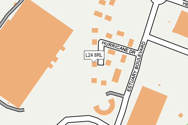
L24 8RL lies on Hurricane Drive in Speke, Liverpool. L24 8RL is located in the Garston electoral ward, within the metropolitan district of Liverpool and the English Parliamentary constituency of Garston and Halewood. The Sub Integrated Care Board (ICB) Location is NHS Cheshire and Merseyside ICB - 99A and the police force is Merseyside. This postcode has been in use since January 2008.


GetTheData
Source: OS OpenMap – Local (Ordnance Survey)
Source: OS VectorMap District (Ordnance Survey)
Licence: Open Government Licence (requires attribution)
| Easting | 341502 |
| Northing | 383158 |
| Latitude | 53.342070 |
| Longitude | -2.880075 |
GetTheData
Source: Open Postcode Geo
Licence: Open Government Licence
| Street | Hurricane Drive |
| Locality | Speke |
| Town/City | Liverpool |
| Country | England |
| Postcode District | L24 |
➜ See where L24 is on a map ➜ Where is Liverpool? | |
GetTheData
Source: Land Registry Price Paid Data
Licence: Open Government Licence
Elevation or altitude of L24 8RL as distance above sea level:
| Metres | Feet | |
|---|---|---|
| Elevation | 20m | 66ft |
Elevation is measured from the approximate centre of the postcode, to the nearest point on an OS contour line from OS Terrain 50, which has contour spacing of ten vertical metres.
➜ How high above sea level am I? Find the elevation of your current position using your device's GPS.
GetTheData
Source: Open Postcode Elevation
Licence: Open Government Licence
| Ward | Garston |
| Constituency | Garston And Halewood |
GetTheData
Source: ONS Postcode Database
Licence: Open Government Licence
| Estuary Business Park (De Havilland Drive) | Speke | 294m |
| Estuary Business Park (De Havilland Drive) | Speke | 295m |
| Dehavilland Drive (Dakota Drive) | Garston | 385m |
| Dehavilland Drive (Dakota Drive) | Garston | 430m |
| Dakota Drive | Speke | 529m |
| Liverpool South Parkway Station | 1.8km |
| Hunts Cross Station | 2.6km |
| Cressington Station | 2.8km |
GetTheData
Source: NaPTAN
Licence: Open Government Licence
GetTheData
Source: ONS Postcode Database
Licence: Open Government Licence


➜ Get more ratings from the Food Standards Agency
GetTheData
Source: Food Standards Agency
Licence: FSA terms & conditions
| Last Collection | |||
|---|---|---|---|
| Location | Mon-Fri | Sat | Distance |
| Spindus Road | 17:00 | 869m | |
| Spindus Road | 17:00 | 12:00 | 872m |
| Windfield Road | 16:30 | 12:00 | 907m |
GetTheData
Source: Dracos
Licence: Creative Commons Attribution-ShareAlike
The below table lists the International Territorial Level (ITL) codes (formerly Nomenclature of Territorial Units for Statistics (NUTS) codes) and Local Administrative Units (LAU) codes for L24 8RL:
| ITL 1 Code | Name |
|---|---|
| TLD | North West (England) |
| ITL 2 Code | Name |
| TLD7 | Merseyside |
| ITL 3 Code | Name |
| TLD72 | Liverpool |
| LAU 1 Code | Name |
| E08000012 | Liverpool |
GetTheData
Source: ONS Postcode Directory
Licence: Open Government Licence
The below table lists the Census Output Area (OA), Lower Layer Super Output Area (LSOA), and Middle Layer Super Output Area (MSOA) for L24 8RL:
| Code | Name | |
|---|---|---|
| OA | E00034155 | |
| LSOA | E01006739 | Liverpool 058B |
| MSOA | E02001404 | Liverpool 058 |
GetTheData
Source: ONS Postcode Directory
Licence: Open Government Licence
| L24 8RF | Estuary Boulevard | 302m |
| L24 8AD | Hercules Drive | 445m |
| L24 8RB | Estuary Banks | 636m |
| L24 8QR | Windward Drive | 775m |
| L24 8QD | The Aerodrome | 791m |
| L19 2QY | Bravery Court | 817m |
| L19 8JL | Banks Lane | 845m |
| L24 8QA | Speke Road | 860m |
| L19 8JU | Banks Way | 865m |
| L19 8JT | Monkfield Way | 880m |
GetTheData
Source: Open Postcode Geo; Land Registry Price Paid Data
Licence: Open Government Licence