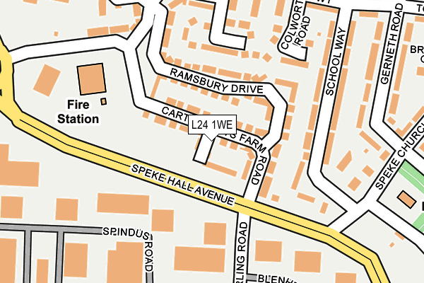
L24 1WE is located in the Speke electoral ward, within the metropolitan district of Liverpool and the English Parliamentary constituency of Garston and Halewood. The Sub Integrated Care Board (ICB) Location is NHS Cheshire and Merseyside ICB - 99A and the police force is Merseyside. This postcode has been in use since June 2017.


GetTheData
Source: OS OpenMap – Local (Ordnance Survey)
Source: OS VectorMap District (Ordnance Survey)
Licence: Open Government Licence (requires attribution)
| Easting | 342679 |
| Northing | 383417 |
| Latitude | 53.344543 |
| Longitude | -2.862446 |
GetTheData
Source: Open Postcode Geo
Licence: Open Government Licence
| Country | England |
| Postcode District | L24 |
➜ See where L24 is on a map ➜ Where is Liverpool? | |
GetTheData
Source: Land Registry Price Paid Data
Licence: Open Government Licence
| Ward | Speke |
| Constituency | Garston And Halewood |
GetTheData
Source: ONS Postcode Database
Licence: Open Government Licence
2022 31 AUG £235,000 |
2017 22 SEP £174,995 |
2, WATCHFIELD CLOSE, LIVERPOOL, L24 1WE 2017 31 AUG £214,995 |
1, WATCHFIELD CLOSE, LIVERPOOL, L24 1WE 2017 23 JUN £179,995 |
GetTheData
Source: HM Land Registry Price Paid Data
Licence: Contains HM Land Registry data © Crown copyright and database right 2025. This data is licensed under the Open Government Licence v3.0.
| Cartwrights Farm Road (Speke Hall Avenue) | Speke | 160m |
| Speke Church Road (Speke Hall Avenue) | Speke | 167m |
| Stirling Road (Speke Hall Avenue) | Speke | 171m |
| Estuary Banks (Speke Hall Avenue) | Speke | 178m |
| Belsford Way (Colworth Road) | Speke | 290m |
| Hunts Cross Station | 1.9km |
| Liverpool South Parkway Station | 2.3km |
| Halewood Station | 3.1km |
GetTheData
Source: NaPTAN
Licence: Open Government Licence
| Percentage of properties with Next Generation Access | 100.0% |
| Percentage of properties with Superfast Broadband | 90.0% |
| Percentage of properties with Ultrafast Broadband | 0.0% |
| Percentage of properties with Full Fibre Broadband | 0.0% |
Superfast Broadband is between 30Mbps and 300Mbps
Ultrafast Broadband is > 300Mbps
| Median download speed | 31.2Mbps |
| Average download speed | 26.0Mbps |
| Maximum download speed | 39.06Mbps |
| Median upload speed | 6.7Mbps |
| Average upload speed | 5.2Mbps |
| Maximum upload speed | 7.93Mbps |
| Percentage of properties unable to receive 2Mbps | 0.0% |
| Percentage of properties unable to receive 5Mbps | 0.0% |
| Percentage of properties unable to receive 10Mbps | 0.0% |
| Percentage of properties unable to receive 30Mbps | 10.0% |
GetTheData
Source: Ofcom
Licence: Ofcom Terms of Use (requires attribution)
GetTheData
Source: ONS Postcode Database
Licence: Open Government Licence


➜ Get more ratings from the Food Standards Agency
GetTheData
Source: Food Standards Agency
Licence: FSA terms & conditions
| Last Collection | |||
|---|---|---|---|
| Location | Mon-Fri | Sat | Distance |
| Spindus Road | 17:00 | 12:00 | 335m |
| Spindus Road | 17:00 | 338m | |
| The Crescent Post Office | 16:45 | 12:00 | 401m |
GetTheData
Source: Dracos
Licence: Creative Commons Attribution-ShareAlike
The below table lists the International Territorial Level (ITL) codes (formerly Nomenclature of Territorial Units for Statistics (NUTS) codes) and Local Administrative Units (LAU) codes for L24 1WE:
| ITL 1 Code | Name |
|---|---|
| TLD | North West (England) |
| ITL 2 Code | Name |
| TLD7 | Merseyside |
| ITL 3 Code | Name |
| TLD72 | Liverpool |
| LAU 1 Code | Name |
| E08000012 | Liverpool |
GetTheData
Source: ONS Postcode Directory
Licence: Open Government Licence
The below table lists the Census Output Area (OA), Lower Layer Super Output Area (LSOA), and Middle Layer Super Output Area (MSOA) for L24 1WE:
| Code | Name | |
|---|---|---|
| OA | E00034155 | |
| LSOA | E01006739 | Liverpool 058B |
| MSOA | E02001404 | Liverpool 058 |
GetTheData
Source: ONS Postcode Directory
Licence: Open Government Licence
| L24 1UY | Cartwrights Farm Road | 73m |
| L24 1WB | Ramsbury Drive | 101m |
| L24 1UH | School Way | 181m |
| L24 1UL | School Way | 229m |
| L24 1WD | Rivenhall Square | 269m |
| L24 1UN | Gerneth Road | 276m |
| L24 1YR | Colworth Road | 294m |
| L24 1WA | Deanland Drive | 298m |
| L24 1XQ | Dymchurch Road | 329m |
| L24 1XR | Lenham Way | 333m |
GetTheData
Source: Open Postcode Geo; Land Registry Price Paid Data
Licence: Open Government Licence