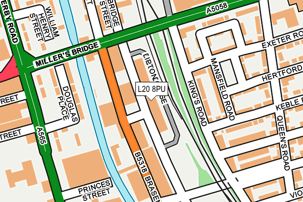
L20 8PU is located in the Linacre electoral ward, within the metropolitan district of Sefton and the English Parliamentary constituency of Bootle. The Sub Integrated Care Board (ICB) Location is NHS Cheshire and Merseyside ICB - 01T and the police force is Merseyside. This postcode has been in use since June 1981.


GetTheData
Source: OS OpenMap – Local (Ordnance Survey)
Source: OS VectorMap District (Ordnance Survey)
Licence: Open Government Licence (requires attribution)
| Easting | 334013 |
| Northing | 394508 |
| Latitude | 53.443192 |
| Longitude | -2.994915 |
GetTheData
Source: Open Postcode Geo
Licence: Open Government Licence
| Country | England |
| Postcode District | L20 |
➜ See where L20 is on a map ➜ Where is Bootle? | |
GetTheData
Source: Land Registry Price Paid Data
Licence: Open Government Licence
Elevation or altitude of L20 8PU as distance above sea level:
| Metres | Feet | |
|---|---|---|
| Elevation | 20m | 66ft |
Elevation is measured from the approximate centre of the postcode, to the nearest point on an OS contour line from OS Terrain 50, which has contour spacing of ten vertical metres.
➜ How high above sea level am I? Find the elevation of your current position using your device's GPS.
GetTheData
Source: Open Postcode Elevation
Licence: Open Government Licence
| Ward | Linacre |
| Constituency | Bootle |
GetTheData
Source: ONS Postcode Database
Licence: Open Government Licence
| Marble Close (Balliol Road) | Bootle | 190m |
| Derby Road (Millers Bridge) | Bootle | 202m |
| College View (Balliol Road) | Bootle | 221m |
| Millers Bridge (Derby Road) | Bootle | 224m |
| Millers Bridge (Derby Road) | Bootle | 321m |
| Bootle Oriel Road Station | 0.4km |
| Bank Hall Station | 0.8km |
| Kirkdale Station | 1km |
GetTheData
Source: NaPTAN
Licence: Open Government Licence
GetTheData
Source: ONS Postcode Database
Licence: Open Government Licence


➜ Get more ratings from the Food Standards Agency
GetTheData
Source: Food Standards Agency
Licence: FSA terms & conditions
| Last Collection | |||
|---|---|---|---|
| Location | Mon-Fri | Sat | Distance |
| Boundary Street | 16:15 | 12:00 | 593m |
| Bootle New Strand Post Office | 18:00 | 12:00 | 881m |
| Litherland Road | 17:15 | 12:00 | 1,098m |
GetTheData
Source: Dracos
Licence: Creative Commons Attribution-ShareAlike
The below table lists the International Territorial Level (ITL) codes (formerly Nomenclature of Territorial Units for Statistics (NUTS) codes) and Local Administrative Units (LAU) codes for L20 8PU:
| ITL 1 Code | Name |
|---|---|
| TLD | North West (England) |
| ITL 2 Code | Name |
| TLD7 | Merseyside |
| ITL 3 Code | Name |
| TLD73 | Sefton |
| LAU 1 Code | Name |
| E08000014 | Sefton |
GetTheData
Source: ONS Postcode Directory
Licence: Open Government Licence
The below table lists the Census Output Area (OA), Lower Layer Super Output Area (LSOA), and Middle Layer Super Output Area (MSOA) for L20 8PU:
| Code | Name | |
|---|---|---|
| OA | E00035523 | |
| LSOA | E01007010 | Sefton 037E |
| MSOA | E02001465 | Sefton 037 |
GetTheData
Source: ONS Postcode Directory
Licence: Open Government Licence
| L20 7BQ | Kings Road | 116m |
| L20 7EF | Mansfield Road | 130m |
| L20 8HE | Brasenose Road | 170m |
| L20 7EQ | Exeter Road | 178m |
| L20 8LX | Douglas Place | 182m |
| L20 7ER | Hertford Road | 183m |
| L20 7ED | Keble Road | 187m |
| L20 7EB | Lincoln Crescent | 192m |
| L20 7ES | Nuffield Road | 193m |
| L20 7DG | Wadham Road | 203m |
GetTheData
Source: Open Postcode Geo; Land Registry Price Paid Data
Licence: Open Government Licence