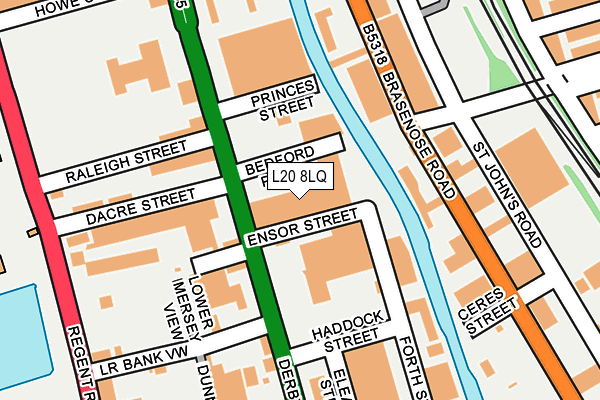
L20 8LQ is located in the Waterfront North electoral ward, within the metropolitan district of Liverpool and the English Parliamentary constituency of Liverpool, Riverside. The Sub Integrated Care Board (ICB) Location is NHS Cheshire and Merseyside ICB - 99A and the police force is Merseyside. This postcode has been in use since December 1994.


GetTheData
Source: OS OpenMap – Local (Ordnance Survey)
Source: OS VectorMap District (Ordnance Survey)
Licence: Open Government Licence (requires attribution)
| Easting | 333917 |
| Northing | 394231 |
| Latitude | 53.440691 |
| Longitude | -2.996302 |
GetTheData
Source: Open Postcode Geo
Licence: Open Government Licence
| Country | England |
| Postcode District | L20 |
➜ See where L20 is on a map ➜ Where is Bootle? | |
GetTheData
Source: Land Registry Price Paid Data
Licence: Open Government Licence
Elevation or altitude of L20 8LQ as distance above sea level:
| Metres | Feet | |
|---|---|---|
| Elevation | 10m | 33ft |
Elevation is measured from the approximate centre of the postcode, to the nearest point on an OS contour line from OS Terrain 50, which has contour spacing of ten vertical metres.
➜ How high above sea level am I? Find the elevation of your current position using your device's GPS.
GetTheData
Source: Open Postcode Elevation
Licence: Open Government Licence
| Ward | Waterfront North |
| Constituency | Liverpool, Riverside |
GetTheData
Source: ONS Postcode Database
Licence: Open Government Licence
| Ensor Street (Derby Road) | Sandhills | 54m |
| Lodwick Street (Derby Road) | Sandhills | 69m |
| Esk Street (Derby Road) | Sandhills | 269m |
| Millers Bridge (Derby Road) | Bootle | 302m |
| Derby Road (Millers Bridge) | Bootle | 386m |
| Bootle Oriel Road Station | 0.7km |
| Bank Hall Station | 0.7km |
| Kirkdale Station | 1km |
GetTheData
Source: NaPTAN
Licence: Open Government Licence
GetTheData
Source: ONS Postcode Database
Licence: Open Government Licence


➜ Get more ratings from the Food Standards Agency
GetTheData
Source: Food Standards Agency
Licence: FSA terms & conditions
| Last Collection | |||
|---|---|---|---|
| Location | Mon-Fri | Sat | Distance |
| Boundary Street | 16:15 | 12:00 | 310m |
| Bootle New Strand Post Office | 18:00 | 12:00 | 1,175m |
| Litherland Road | 17:15 | 12:00 | 1,387m |
GetTheData
Source: Dracos
Licence: Creative Commons Attribution-ShareAlike
The below table lists the International Territorial Level (ITL) codes (formerly Nomenclature of Territorial Units for Statistics (NUTS) codes) and Local Administrative Units (LAU) codes for L20 8LQ:
| ITL 1 Code | Name |
|---|---|
| TLD | North West (England) |
| ITL 2 Code | Name |
| TLD7 | Merseyside |
| ITL 3 Code | Name |
| TLD72 | Liverpool |
| LAU 1 Code | Name |
| E08000012 | Liverpool |
GetTheData
Source: ONS Postcode Directory
Licence: Open Government Licence
The below table lists the Census Output Area (OA), Lower Layer Super Output Area (LSOA), and Middle Layer Super Output Area (MSOA) for L20 8LQ:
| Code | Name | |
|---|---|---|
| OA | E00165715 | |
| LSOA | E01006778 | Liverpool 014E |
| MSOA | E02001360 | Liverpool 014 |
GetTheData
Source: ONS Postcode Directory
Licence: Open Government Licence
| L20 8LU | Lodwick Street | 99m |
| L20 8LN | Derby Road | 104m |
| L20 8DL | Raleigh Street | 131m |
| L20 8HG | Brasenose Road | 158m |
| L20 8HE | Brasenose Road | 169m |
| L20 8JW | Forth Street | 185m |
| L20 8TD | Derby Road | 230m |
| L20 8LX | Douglas Place | 290m |
| L20 8LG | Derby Road | 310m |
| L20 8LJ | Derby Road | 312m |
GetTheData
Source: Open Postcode Geo; Land Registry Price Paid Data
Licence: Open Government Licence